User: | Open Learning Faculty Member:
Danielle Kinsella, November 16th 2018
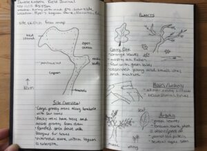
The area I have decided to study falls within the Garry Oak ecosystem at Pipers Lagoon Park in Nanaimo, BC. My reconnaissance of the area was November 11th 2018 at 2:55 pm. The weather was sunny with a bit of wind, the temperature was a warm 8°C fall day.
The landscape consists of a tied island attached to Vancouver Island by a ~350m long tombolo. The tied island is 275m long in the NW/SE by 200 m NE/SW (see Figure 1). Together, the landforms create a large lagoon which undergoes drastic water level changes every day with tidal movement. The north side of the park consists of rocky bluffs, however, elevation does not exceed 20 m (see Figure 2). The tombolo has relatively flat topography, while the east side receives direct waves.

Figure 1: Satellite image of study site. Green outline indicates the park boundary and extents. Created using Google Maps.

Figure 2: View of Pipers Lagoon facing North.
The area ranges from forested areas, grasslands with scattered trees and shrubs, to intertidal zones with dense aquatic vegetation. There are a variety of vegetation species within the park, however, the only animals sighted were ducks, geoducks, seagulls and a bald eagle. Along the tombolo is largely grassland with shrubs, with a few Garry Oak and young Arbutus trees. The main portion of the park is forest consisting of mainly Garry Oak, Douglas fir and Arbutus trees. Several shrubs occur along the forest floor as well as some invasive species such as Himalayan Blackberry and English Ivy.
Possible Subjects and Questions
1. What daily fluctuations do the organisms in the intertidal zone undergo each day and how does it affect their internal nutrient composition?
Identifying and studying the species located here, you can determine their relative abundance. This method of analyzing the community may indicate which species is more adapted and able to survive harsher conditions. Another possibility would be to analyze the salt content in different species of plants.

Figure 3: left photo: sea asparagus, right photo: below surface geoducks.
2. Are the invasive plants a threat to the keystone species in this ecosystem? Do they affect all other vegetation species surrounding them?
While observing the Garry Oak tress I noticed along the ground some Himalayan Blackberry plants. They were growing between a young and old Garry Oak (see Figure below), and nearby was a juvenile arbutus tree. English Ivy was also observed along the floor of more dense forest, where it slowly crept up Garry Oak and Douglas fir tree trunks.

Figure 4. Left photo: Invasive species near Garry Oak. Right photo: young arbutus found nearby.
3. Does the spatial distribution of tree species vary along the perimeter of the tied island?
The north side experiences direct wind from the ocean, whereas the south side is protected from harsh winds and does not experience harsh waves. Also, the north side is rocky bluffs where it is too steep for several trees to grow. Are the two areas affected differently by sunlight and/or the physical environment surrounding them, and does it affect which tree will grow there? The three distinct tree types are: Garry Oak, Arbutus and Douglas fir. Walking around the park it appeared there were many places with only a single tree species, or with several.

Figure 5. Left photo: Southwest side of tied island. Right photo: Rocky bluffs on North side of island.

Figure 6. Trees growing out from rocky hill. Left photo: Garry Oak. Right photo: large Arbutus tree.

Figure 7: Young Douglas-fir tree.
Field Notes: