User: | Open Learning Faculty Member:
In my study area at Fish Creek, I have noted frequent traffic by large mammals in the form of tracks in the snow. I have decided to study the patterns of travel used by the area’s large mammals. Specifically, I will be focusing on Odocoileus hemionus, Canis latrans, and Vulpes vulpes. Though I have noted the presence of Alces alces tracks, I believe them to be too intermittent of visitors to the area to use as a focus species, though I will continue to note their presence.
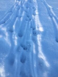
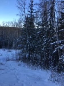
I will be using four gradients to observe the presence of these mammals. First, the top of southern slope of the Fish Creek gully. This is the open grassland of the golf course. So far, this gradient appears to have the heaviest traffic from Odocoileus hemionus. The second gradient is mid slope on the southern slope, approximately 70% Picea Glauca, 30% Populus Tremuloides, with a mostly closed canopy. This gradient also includes an open pipeline right of way. It is steep, about 70%-90% slope with level benches contouring the hill. Here, there is presence of tracks from Canis latrans, Vulpes vulpes, and Odocoileus hemionus.
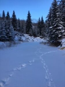
The tracks from the canine species seem to go cross slope as well as up and down slope, whereas the tracks from Odocoileus hemionus descend from the first gradient and then cut cross slope along apparently established paths. The third gradient is the gully bottom. This gradient is mostly open, though the steepness of the banks gives it an enclosed feeling. The watercourse of Fish Creek runs through the middle, frozen now, likely for the winter. It is often shaded, and on the level banks of the creek grows mostly grasses and a few shrubs, though these are now buried by snow. In this gradient there is presence of Canis latrans and Vulpes vulpes tracks, often following the frozen watercourse.
The fourth gradient is the northern slope (south facing). This gradient is steep (>100%) and open with only the odd small Populus tremuloides present. Here I have noted a few Odocoileus hemionus tracks, though they are becoming less frequent as the snow continues to fall.
These four gradients are a good representation of a common geographical feature here in the Peace River region of BC. There are many steep gullies with waterways at their bottoms and fields at the top. Where the waterways run West-East, they have both north and south facing slopes with very similar topography and vegetation to my study area. the three species I have selected to study are also very common in the Peace River region and, though the scope of my study in this course will be too narrow to cover it, I would expect to find similar behavior among these species in other areas in the region that are similar to my study area.
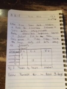
Based on my observations, my hypothesis is that Odocoileus hemionus, Canis latrans, and Vulpes vulpes will use the north facing slope most frequently for travel in the winter months. I predict that as snow continues to fall over the winter months, the open south facing slope, gully bottom, and the top of the southern (north facing) slope will house the deepest snowpack of the gradients, while the mostly covered southern mid slope gradient will have less snow accumulation on the ground. I believe this will lead to heavier traffic from large mammals, seeking easier travel routes. Based on the above, the response variable will be the abundance of Odocoileus hemionus, Canis latrans, and Vulpes vulpes tracks present at any given gradient (categorical). The predictor variable will be snowpack depth at the different gradients (continuous).