User: | Open Learning Faculty Member:
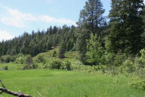
The area I have selected for this research project is a transitional zone between a grassland and forest landscape located in Vernon BC. Despite this site being undeveloped and natural it is in close proximity to adjacent property development. I first visited this site on June 6th 2020. It was a sunny 10 degree morning.
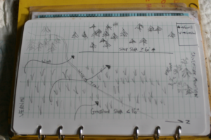
The size of the study area is approximately 5000m2 with an elevation of 750m. The slope aspect is East and on a continuous 16 % slope in which the grassland meets the forest. There is also a steeper section of forested landscape that ranges from 60 to 80% slope. It falls within the Interior Douglas-fir BEC zone classification for ecosystems as indicated on iMapBC.
Observed Tree & Shrub Species:
- Pseudotsuga menziesii
- Pinus ponderosa
- Populus tremuloides
- Pinus contorta
- Amelanchier alnifolia
- Symphoricarpus albus
- Rosa gymnocarpa
Observations:
While comparing the vegetation and ecosystems variance on this site I noticed that the lush grassland was primarily restricted to the more gentle slopes (<16 )where as the adjacent steep slopes (> 60) was an open forest type ecosystem composed of Fd and Py. On another note, I noticed that in the short time I was on site there was considerable mix of complete calm with occasional gusts of heavy wind. I suspect that the topography plays a role in funnelling the wind alongside this mountain. I also found what I assume to be the femur of cow adjacent to edge between grassland and forest as well as a dilapidated wooden structure.
Questions:
- How does slope and/or site specific weather patterns influence vegetation and ecosystem composition?
- Do soil properties change between grassland and the adjacent forest ecosystem?
- Was the grassland at one time pasture for grazing livestock? If so how has that impacted vegetation/soil properties?