User: | Open Learning Faculty Member:
Preamble: After reassessing my planned sampling methods and study site, I began collecting my formal data on August 5th, 2020. In this blog post, I have included information regarding some changes to my project. I have opted to include these updates in this post, rather that the original blog posts to avoid the need for the reader to navigate to my other blog posts to understand the context in which this data was collected.
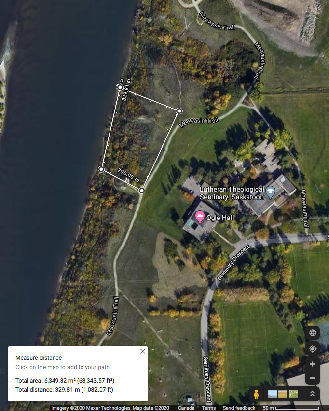
Study site updates: Due to the difficulty in navigating some of the steep slopes within my initial study area, and avoiding some areas that may confound the project, I have redefined my study site. The original study site was an area of approximately 38 576 m2 in size and encompassed a ravine. I desired to study the forb species abundance and distribution along the riparian-upland gradient on the eastern bank of the South Saskatchewan River. However, the ravine threatened to confound my project (having a separate species profile and elevation gradient), and some of the cliffs within the original study area were going to be too difficult to navigate. Therefore, the study area was reduced to 6 349 m2 and is depicted in Figure 1.
Hypothesis updates: My original hypothesis involved investigating forb species abundance and distribution as they relate to the distance from the river. However, I have now opted to shift my focus towards elevation (rather than distance). Furthermore, in an attempt to address the processes behind forb abundance and distribution, I have decided to estimate soil moisture along the gradient.
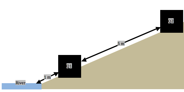
Sampling method updates: Following some advice and reflection on my proposed sampling methods, I have decided to adopt a systematic sampling approach (along transects) within the study area. Each transect will run perpendicular to the shore of the river and contain 11, 1 m2 quadrats that are spaced 5 meters apart (Figure 2). Ten randomly generated locations at the shore of the river were chosen and the first quadrat in each transect is to be laid at 1 meter from the river’s shore. Along these transects: I have been collecting forb species abundance, noting the proximity to river, estimating soil moisture (by hand texturing), and noting whether there is a tree/shrub canopy hanging over the quadrats.
Data Collection: Three replicates (transects) were sampled on August 5, 2020 between 9:30 AM and 6:30 PM. As stated above, each transect consisted of 11 sub-samples (quadrats).
Transects proved difficult to implement because the slope was extremely steep in some locations. Working from the river, I would lay a quadrat, collect data, then measure 5 meters to the next quadrat location. Some locations arose where I would not be able to move in a straight line (often up a cliff); therefore, I would have to mark the location of the previous quadrat, navigate to the new location via an alternate route, and measure backwards to maintain a consistent distance between quadrats. In addition, the upper area of the riparian zone is dominated by dense stands of Caragana sp. and Amelanchier alnifolia (Saskatoon berry) shrubs. This region was particularly time consuming to navigate; however, it was still feasible. The locations with a dense shrub canopy exhibited a notable absence of forbs. Therefore, at the sixth quadrat in transect one, I decided to begin noting when a canopy of shrubs or trees hangs over each quadrat. In order to maintain consistency, I navigated back to the previous five quadrats to collect this data before continuing to the seventh quadrat in the first transect. Overall, the largest problem in implementing my sampling technique was time. Not being able to complete all ten of my replicates in one day will mean that I may not have consistency with soil moisture between sampling days. This can be mitigated by ensuring that my sampling is, in the very least, completed within a timely manner (over the next few days). In addition, I will be navigating to some of my previous points on subsequent sampling days to verify that the moisture content of the soil has not changed. If it has, I will need disregard my previous soil moisture data and plan for an individual day of soil sampling to control for moisture variances.
Despite having only sampled from three transects, I am noticing ancillary patterns related to my hypothesis. The transects closest to the river are all saturated with water and this saturation level quickly declines as you move up in elevation. Consequently, many forb species exhibit preferences for different elevations. For example, Astragalus pectinatus (narrow-leafed milk-vetch), Cirsium arvense (Canada thistle), and Liatris punctata (dotted blazing star) display an extreme preference for dry (0-25% saturation), upland locations. In addition, Hedysarium alpinium (alpine hedysarium) and Astragalus americanus (American milk-vetch) are strongly associated with heavily saturated (75-100% saturation), low elevations. However, some forb species like Solidago canadensis (Canada goldenrod) do not appear to display a preference for any elevation or moisture content.
REFERENCE LIST:
Google Maps [Internet]. c2020. Canada: Google Maps; [accessed 2020 July 29]. https://www.google.ca/maps/@52.1378074,-106.6412387,549m/data=!3m1!1e3