User: | Open Learning Faculty Member:
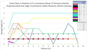
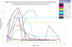
I ended up organizing my data into two graphs containing dependent variables of cover class and average height, and then distance along the transect in meters was the independent variable for each plot. Since I had 15 transects with a maximum of 15 1 m2 quadrats along each transect. My data lined up nicely using distance on the x-axis, but I had to use 15 separate colors, and it took some time to organize the colors and create a legend. One interesting observation from plotting the data was noticing how pervasive Himalayan Blackberry is around Nanaimo. I also noticed how spikes in data occurred around my perceived edge environment in most transects.
mean average height and cove class of R. armeniacus was 0.9 m and 2.09 respectively across all transects. I also saw minimum values of 0 for height and cover class and maximums of 2 m and 6 (95 – 100%). Median values across all 15 transects were also 0.7 m and 1.7 (19%).
In hindsight, I would have chosen 5 to 10 plots along slopes with different aspects and incorporated stand direction into my hypothesis. I also did all of my samplings on the same day so growth was similar across the field site, but if I did the project again I would organize another sampling day a month later.