User: | Open Learning Faculty Member:
On site: 17:00 hours, February 17th 2021
Location: Mission Creek Regional Park
Weather/conditions: 3°c southern winds, light dusting of recent snowfall, late winter conditions with the sun nearly set.
The chosen study area is approximately five square kilometers (paced) within Mission Creek Regional Park in Kelowna, BC. Located west of the Springfield road park entrance, and on the south side of the creek. The area spans north to south from the creek bank to the apex of the upland north-facing slope, crossing a dyke/trail and forested flood plain. The area is bordered by walking trails on the east and west sides. Historically, Mission Creek was narrowed to protect the city and the dykes are now a popular walking path.
Observations:
The creek flows east to west/southwest, and is mostly frozen on the surface after the recent cold snap. Only small pockets of flow remain visible. The creek bank is comprised of riprap leading to a shrub and small deciduous tree riparian zone, meeting with the dyke built parallel to the creek.
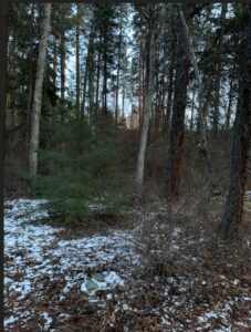
The area descends back to creek elevation (several meters) into a forested flood plain/depression zone to the south. This flood plain contains diverse layered vegetation, with dominant shrubs identified as Oregon Grape (Malonia aquifolium) and Common Snowberry (Symphoricarpos albus). The tree population was fascinating, with such a variety of mature growth; Ponderosa pine, Birch, Douglas Maple, Poplar, Alder were identified. A few young evergreens were spotted growing in the midst. Decaying logs and leaves of several species were noted on the forest floor. Transitioning further south into the uplands, the vegetation thins into that of a dry forest consisting of Ponderosa Pine and Grass at the slope apex.
Questions:
- Is the concentration of deciduous trees in the flood plain related to the creek proximity? or the natural depression of the area?
- Are there fewer Ponderosa Pine closer to the creek? possibly more competition or less favorable conditions?
- Does the human disturbance in the area impact the growth and dispersal of the common snowberry (Symphoricarpos albus)?
References:
Loverin, K. (2021). Flood plain looking south towards uplands. [photograph].
Parish R., Coupe R., Lloyd D. (1996). Plants of Southern Interior British Columbia. Lone Pine Publishing.
Sounds like a good study area and your questions are all on the right track. Good luck narrowing things down to one study question and associated hypothesis.