Post 5: Design Reflections

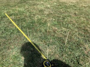
While implementing my sampling strategy, some difficulties arose when deciding how to ensure randomization when selecting which sample units to measure. I needed to find a sampling method that allowed me to randomly choose a plant by assigning numerical values to put into a random number generator. I originally wanted to divide each strata into a grid of coordinates, but found out quickly that this was not feasible. I found it difficult to make a grid small enough that each box contained only one stem, therefore, I ended up using the distance-based method. I then found that as I was measuring the distances to the selected point, the plants were not fixed in space and so it was difficult to accurately select the correct plant. I then decided to place the measuring tape on the ground and measure to the bottom of the stem to ensure accuracy. 

I found some of the data collected to be surprising, especially in the low degree of sunlight exposure strata. What surprised me was the degree of variation within these strata, especially that of the low degree strata. In this area, most of the plants were under 90 cm tall but there were a few that reached almost 110 cm. Because of this, I decided that five replicates was not enough data to accurately represent the population in each strata. I plan to continue to use the distance-based sampling method with the random number generator, but will generate more replicates so that I have a total of 10 sample unit measurements in total for each strata. I think that increasing the sample size will better represent the sample and decreases the variance within each strata. 


Edit:

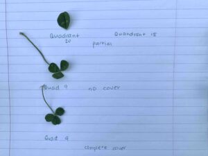
I decided to revise my research study, and focus on density of the Canada goldenrod as my response variable. I believe density is a better representation for plant growth success, as it eliminates other factors. Height would not be an accurate representation of plant success, unless I measured plant growth over a period of time. Due to the time constraints of my study, I would not be able to record meaningful data for differential plant growth among goldenrod plants in the different strata. As such, I have revised my study design and sampling methods to measure goldenrod density at different levels of sunlight exposure. To calculate density, I will use a stratified random quadrat sampling method, using the same strata that I initially identified. I will divide my study area into three 10 m by 10 m strata, representing low, moderate, and high levels of sunlight exposure. I will randomly place 10 quadrats in each strata by using a random number generator to generate two coordinates. I will continue generating coordinates until I have 10 points in each stratum. I will then locate these points on my study plot by placing a measuring tape on the ground and measuring the appropriate point, which will represent the bottom left-hand corner of the quadrat.

Blog Post 5: Design Reflections

Blog Post 5; Design Reflections


My sample strategy was Systematic sampling which was easy to design. I found a few problems with the design and statistics sample sizes. Statistically speaking, “the sample should be no more than 10% of the population” (De Veaux et. al, 2014, p.411). To obtain a sample of only 10%, I needed to create a smaller quadrate, decrease the amount of transects of increase my plant coverage.

I decided to divide my single plot into 2 separate plots. Both plots will be 5m x 5m. One which contained soil with a large amount of moisture and one which contained soil with low moisture. To make sure I had less than 10% of the population within my sample units, I will place 4 transects East/West and 4 North/South. This also allows me to obtain 16 samples in each plot, which is larger than the required 10 samples per area. My quadrate must then be 17centimeters x 17centimeteres to give me a total of 2.72m2. This puts my sample under the 10% of the population.

I also altered the plots so that the sample areas were not on the boundaries, and did not overlap between the “Wetter” and “Drier” areas. I will continue to use the Systematic sampling techniques as it worked well for my data documentation.

The modification will help me to easily distinguish between the two areas of moisture, while allowing to be obtain a proper sample amount in comparison to the total population.


Citation

De Veaux, D., Velleman, P., Bock, D. Intro Stats Fourth Edition. Copyright 2014, 2012, 2009. Pearson Education, Inc. Upper Saddle River New Jersey.

Blog Post 5 – Design Reflections

When implementing my sampling strategy, I found that the process took much longer than expected. Based on the experimental design I chose I utilized stratified random sampling because I needed to have a plot from each “location” along my gradient. I wanted to use an adequate sized plot so I decided to divide my plots into 25 smaller quadrants in an attempt to be more accurate and ease the process of counting the clovers. Unfortunately, the act of splitting the plots took a long time. However, I do think it was beneficial to use the 12 inches by 12 inches quadrants.

The data collected was not overly surprising, I was correct in expecting the highest abundance to be found in the no shade area. However, I was surprised that the clovers observed in the partial shade location were noticeably larger than the clovers from all other locations. They did also seem to be healthier and thriving more compared to the clovers found in other locations.

My only difficulty in implementing my sampling strategy was purely the duration. Although it was not difficult both the counting of the clovers (which were more numerous than I had thought) and the plotting and measuring of the quadrantswere very time consuming.

I will continue to use the same technique because I believe it yielded the most accurate results and feel confident with how my data collection went. If I was to use larger quadrants it would increase my chances of error.

Post 5: Design Reflections

I used a distance-based random sampling method to gather information about the species diversity along the gradient of my research area. I chose a point in roughly the center of each sub-site to measure from, just to make sure I didn’t wander too far out of the research area and skew my data. I set the random number generator on my phone to have a maximum of 4, then chose two cardinal directions. (1 = N, 2 = E, 3 = W, 4= S). I then set the number generator to have a maximum of 25 and walked the generated number of steps in both random directions, then recorded my data on the closest tree and marked it with a ribbon.  I experienced difficulties collecting data in the second sub-site because the terrain was so uneven and the vegetation that grew around the rocky outcrop in sub-site 3 was very thick.  The data was not very surprising, as I’ve spent most of my life walking through the forest of my research area and have become familiar with the species that grow there and their spatial patterns. The random distance-based sampling technique I used was easy to implement and I will continue using it to collect further data. By using a random number generator on my phone and beginning from a predetermined center point, the abundance of each species of tree was easy to categorize and record in my field journal as I marked each tree that I had already sampled with a ribbon, as to avoid double-counting.

Blogpost 5: Design Reflections

The largest issue found with my sampling strategy would be time constraint. Due to the large number of samples which I wanted to collect in order to create as accurate of a representation as possible, I had to be sure to schedule a full afternoon and evening to be out in the field.

Additionally, occasional thick vegetation growth slowed down data collection due to the method used; pacing at a set compass bearing meant that I had to go through the thick vegetation (being careful to cause little damage/disturbance) rather than around it in order to have the correct number of randomized paces.


The data collected was not very surprising. The only piece that surprised me was how little of the Knapweed grew in the canopied forest; while visual observations suggested this, the samples had virtually no occurrence of the Knapweed.


I do not plan on modifying my approach to collecting data. While significant amount of time is required for my approach, when considering the number of samples taken it is fairly efficient. I think that my data collection methods align well with the hypothesis that I am trying to test.


EDIT: The sampling design was changed to a randomized transect method. Ten transects were randomly chosen using a randomizer app on my cell phone. Transects were sampled every 10 metres for the presence/absence of Knapweed and the cover type at the sample point. This method took roughly 1/3 the time previous method required and provided more sound data to analyze. Similar difficulties with thick bush areas were encountered with this method, however they were not insolvable instances. Similar patterns were noticed with collecting data where Knapweed had a low frequency in the canopied area and a higher frequency in the open grassland. Further statistical analysis is required for the data.

Blog Post 5!

The collection of data in Module 3 went very well. A difficulty that I encountered was finding tide pools at the high tide region since most of them at McNeil Bay are at sea level. There were many more at the low tide region but I was only able to randomly select 5 from down below and had them spaced apart by at least 1 meter (2 steps). The water in the tide pools further down was quiet murky so it was hard to see what was inside all of the pools. Since I was measuring cover for the algae, I collected that data first and then looked for the individual species that could have been hiding underneath. The data that I collected was not overly surprising because I did see more biotic species (fish) in the pools closer to the ocean. I did however notice more seaweed cover at lower levels which I thought I would find more of higher up. I will collect the data in the same way for my final collection because I did not encounter any serious difficulties. I could improve the data collection by being more precise with the the sampling technique using transects along a measuring tape. This will improve the accuracy of pools that are in different elevation gradients.

BLOG POST 5

For the initial collection of data, there were no issues encountered. However, in some areas close to the industrial site, I observed a much denser canopy of the nodding onion plant than expected. In the future, I plan to carry out soil and air quality testing of the presence of heavy metals in these areas at proximity to the industrial site. This might explain the higher than expected amount of the nodding onion plant in some patches of land close to the industrial site.  Areas at proximity to the industrial site might have a higher penetrance of sunlight than areas farthest from the industrial site and this might be a plausible explanation for the denser than expected canopy of nodding onions closest to the industrial site. Additionally, wind direction might be of importance and has to be taken into consideration when performing the sampling of plant species in this area. One change that I will perform in the future will be to determine the prevalence of more plant species other than the nodding onion species described above. This will permit to have a more general overview of all species that might be affected by the presence of heavy metals in the soil.

Post 5: Design Reflections

While performing my initial data collection survey I had no issue implementing my multiple transect line survey. The data collected was somewhat surprising as the amount of observed paper birch along the disturbed open canopy area was much great that expected. After receiving feedback I plan on changing some of the aspects of my study. I plan on incorporating more transects and plots that my initial sampling method. This change should ensure that the data collected is more accurate. Another change I will make in the future is to look at more species than just paper birch in order to determine if it is simply this tree that is observed greater due to open canopy or if there are others that also will see an increase. This change will allow me to determine whether open canopy has a change in overall forest composition or if it simply favours certain growing conditions for some species.

Blog Post 5: Design Reflections

I visited my site for the third time on July 23rd, 2019 at 1511 hours to collect initial data for the small assignment submission. I chose the Stratified Random Sampling technique to select 5 plots that were then sampled for Common Fern Moss using 1m2 quadrats. My reasoning behind choosing Stratified Random Sampling is that my backyard is not homogeneous- it receives higher amounts of sunlight in specific areas and there also seems to be a reoccurring pattern in the locations where my dog urinates. I believe this technique of sampling would help avoid underrepresentation of the vegetation in my yard. I took 1m2quadrats comprised of a golf driver and a measuring stick and gave my best estimation of the percentage of cover of Common Fern Moss relative to the entire area of the quadrat. I then took the percent cover values of each replicate and calculated the average percent cover of Common Fern moss. This was done to make somewhat of a generalization about its abundance in my backyard. The response variable is percent coverage of the Common Fern moss relative to the quadrat area and the predictor variable is the absence or presence of grass. One difficulty I ran into during sampling was the tough decision on whether or not to include ‘Density’ in a table on my datasheet. Moss is a very tricky plant to measure or count individuals within a species, as the individual stems are hidden in the soil, small and can be closely surrounded by other stems. I originally visited the site thinking I could find a way to measure the abundance of the individuals using a count method. However, I came to the conclusion that the most efficient way to sample moss in this experiment was to use percent cover. The data received from this type of data collection showed that two plots closer to the South fence had a higher percent cover, and this did not come as a surprise to me as these areas receive less shade relative to the other plots, and are areas with bigger patches of dead grass. I plan to continue using this method of sampling as I continue working on my Field Research Project, however I hope to modify my approach by finding another measure of abundance that is time efficient and more accurate. By adding another common measure to the data collection process, I believe that my data will become more representative of my site and will allow for a more in-depth final report.

Blog post 5: Design Reflection

During my data collection in the field, the systematic sampling strategy proved to be efficient at surveying the area. The few difficulties I encountered during the sampling did not damage the quality of my data in any way. First, the determination of transects was simple, but keeping that transect straight as I collected my subsamples across the field seemed to be a challenge. For the last three transects, I established three or four checkpoints along each transects in order to keep me straight. Having closer targets greatly improved the quality of my transects. Secondly, making my way along a transect turned out to be slightly more challenging than I expected. The vegetation got pretty dense in some portions of the field. I always managed to make my way through it but I had to push through some plants and small shrubs. Applying the quadrat down never was an issue. I would simply drop it over the vegetation of the area, however tall or dense that was.

The data was not surprising to me. These first samples even seem to play in favour of my initial hypothesis – more flowers appeared as I sampled away from the beach. One noticeable aspect of my data was that all types of flowers seemed to be displayed in clusters.

I think that my systematic approach to survey the site was the best option. The data collection was performed with minimal difficulties that were all overcame to maintain the essence of the systematic method. It eliminates the possibility of bias, and more samples will only add to the reliability of my data.