Blog Post 1 – Observations

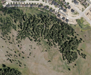
The area that I have selected to observe is a small community park near my house that is frequented by both humans and animals. I visited the area on August 3rd, 2019 at 14:01. The temperature was 18 C˚ and the weather was sunny with a light breeze. The park is situated in a residential neighbourhood in Victoria, BC. The park is mostly open flat grassland with trees growing in some areas. The size of the park is approximately 0.32 hectares (this information was sourced from the district of Saanich website).


I identified roughly three different stratums; open grassland with no shade and no trees, an area with large deciduous trees and constant shade and an area with smaller trees which provided some coverage/shade. I observed the difference in organisms which grew in the different stratums. Overall, the dominant species were clovers, grass and two different species of deciduous trees.


3 questions that could form the subject of the project


  • In what ways does the proximity to a residential area effect the species diversity and richness?
  • What causes the clovers to grow in clusters rather than dispersed throughout the park?
  • What effect do the different trees/shade have on the organisms which live below?


BIO 3021 Blog Post 1: Observations

BIO 3021 Blog Post 1: Observations

Adrienne Burns

August 19, 2019


I have selected to observe a Christchurch, New Zealand, backyard landscape. I live in the city center and it is an easily accessible area which I can monitor every few days. It is currently winter in New Zealand and the weather varies drastically from below freezing temperatures to 18 degrees Celsius.


I began the study of the backyard landscape on 14/08/19 at 5:22pm, which is the winter season. The temperate was 9 degrees Celsius with no strong winds. The study area is 35 meters by 18 meters. Most of the landscape is grassland, with 2 areas of mixed evergreen trees and shrubs. Amongst the grassland, there are 4 fruit trees; Pear, Plum, Lemon and Limes. The grassland is uneven terrain, with the section through the middle containing higher levels of soil. The upper right and lower right quadrants, to the right of the fruit trees have a small dip, where the soil level is approximately 3 inches lower than the middle of the lawn.


I found it interesting that even though the grass landscape is mostly a level surface area, there are pockets that seem to hold more moisture. On the upper right quadrant, the grass is softer with more water than the middle section of the site. Are there different plants in the dry areas as opposed to the wetter soil areas? I noticed a large area of Wax weed (Hydrocotyle heteromeria) in the areas of higher moisture content. I also noticed that there was an extremely large amount of White clovers (Trifolium repens) all over both of the lawns wet and dryer areas. It seemed as if they preferred the sunny areas, but is there a pattern to their distribution as they were rarely found in the shady areas? I also observed large areas of Couch grass (Elymus repens). I found it odd that they seemed to have a pattern of being more present near concrete edging. They were noticeable around the edges of the concrete block that held up the clothesline and near the walk ways. Is Couch grass more tolerant to unhospitable environments that allow it survive in these areas where common lawn grasses are found less?

I am most interested in the large patches of Hydrocotyle heteromeria in my lawn, so I may do my Field study on this interesting plant.


Blogpost 1: Observations

I visited a natural area behind my house at 7:45 in the evening until about 8:35. The temperature was 22°C and the weather was sunny with light breezes.

The natural area is owned by the city and is sandwiched between residential area and agricultural land reserve. It is situated on the side of a north-facing mountain with residential are being at a lower elevation and agricultural land reserve occupying the upper portion of the mountain. The size of this area which I observed is very roughly 6 hectares (measured using google maps).

There are three distinct areas which I identified during this observation period; Forested, Forested with minimal/no canopy, and open grassland.

The dominant species of the forested area are Pinegrass covering the vast majority of the ground and Douglas Fir trees occupying most of the canopy. Numerous other species were also observed throughout the area. The dominating species in the open grassland was what appeared to be crested wheatgrass.

Some questions which I had while walking throughout the area were:

-Why does very little grow in the ravines (see attached photos)?

-How does the proximity to a ravine affect species richness?

-What influences the formation of large patches of medium-sized shrubs?

-How does the proximity to the residential area affect species productivity/ species richness?

Google maps view of visited area

Blog Post 1: Observations

The area that I have selected to observe for my Field Study project is my backyard, located in southwest Calgary, near Stanley park. I chose this area because it will remain easily accessible throughout the span of this project. My backyard is approximately 54 m2, and is composed mainly of grass and fenced off garden areas on the North, East and West sides of the yard. There are alternating columnar aspen (Populus tremula ‘Erecta’)and bakeri spruce trees (Picea pungens ‘Bakeri’)on the east side of the fence, providing the majority of shade in the yard during the summer months. There is another columnar aspen as well as a Japanese lilac tree (Syringa reticulata) which also account for the shade in the yard during the day. Other plants featured in the gardens include: spirea (Spiraea), lemongrass (Cymbopogon)and pink and white rose bushes (Rosa).


I took observations on June 17th, 2019, in the midst of summer, from 5:11 pm to 6:00 pm. There was a bit of overcast with thunderclouds approaching from the North; the temperature was 23 degrees Celsius. During my visit, my first observation was the very prominent moss growth along the South and East sides of the yard, where the grass gets the most shade, and the patches where my dog chooses to urinate. This causes dead patches, where the moss is found. I noticed an area of what I believe to be rotten moss, and I am curious to figure out the cause of such a small affected area that is surrounded by live, healthy moss. Another interesting observation was a small area of grass where the blades of grass are partly white in colour.  I discovered plenty of ants making their way up and down the columnar aspens, and upon further inspection, I noticed that these ants are burrowing holes into the bark. I also spotted many ants surrounding an ant hill underneath a rose bush close by.


These observations made during my first visit to this area have sparked a few questions that I wish to look into:


  1. Based off my observation of the selective moss growth on the South and East sides of the yard, I am wondering if shade, moisture, and bare soil/dead grass are the main factors contributing to the abundance of moss in these areas. I am also eager to figure out the cause of what I believe to be rotting moss in a small area near the fence.
  2. The ants crawling up and down the columnar aspen trees were something I’ve never seen before. Do these two organisms partake in a symbiotic relationship? If so, which type?
  3. I am curious to figure out the cause of the white blades of grass in a small area under the Japanese lilac tree. Could this be from an applied chemical or is this a natural occurrence?

BLOG POST 1

The object of my study is the soil cover of the reference area near my house. Soil samples for heavy metal content were taken at a profile depth of 0-10 cm and at a profile depth of 30-40 cm. Monitoring observations on polluted lands include field surveys, laboratory analysis, mapping lands (soils), and a summary of the materials obtained. In my opinion, the greatest danger to the soils of suburban lands is represented by atmospheric dust and gas dumps of industrial enterprises, with which waste is transported over long distances. I chose this topic because of the presence of active sources of p0llution and the nature of the structure of the surrounding soil cover. Considering the close relationship between the direction of the wind and the range of dust and gas transport before sampling, the direction of the prevailing winds in the area is specified at the nearest weather station. I used the azimuth method to determine sampling points. To identify patterns of horizontal and vertical migration of heavy metals, I chose key sites of the monitoring network that were located on flat, transit accumulative zones of slopes as well as floodplains on soils of different grain size. In this regard, the question arose about the organization of special observations of the state of the environment and its anthropogenic changes in order to assess, predict and timely warn about possible adverse effects, i.e. on the introduction of a permanent surveillance monitoring service

Blog Post 1: Observations

Blog Post 1: Observations

The area I have chosen to study is a flat, grassy field that backs onto a relatively steep mountain slope in a suburban neighbourhood. The area including the entire field and a portion of the slope that I have chosen to study is approximately half of an acre in size. My first visit to the site was July 11, 2019 (considered to be summertime in Terrace, BC), in the early evening (6:00 pm). The weather was overcast, slightly raining, with a cool breeze. Vegetation in the area included ferns, tall grasses, pine and birch trees, clover, low lying plants with broad leaves and a red stem, Saskatoon berry bush.

Along the base of the slope, there looked to be a disproportionately higher number of ferns (Athyrium filix-femina). But at higher elevations, taller trees such as pine and birch appeared to be dominant. This inspired my first question, how and why does the species composition change along the elevation gradient?

I noticed approximately five individuals of a bird species with a brown and white speckled stomach. They could possibly be brown thrashers. The birds seemed to be perching mostly in the Saskatoon berry bushes. This led to my second question, were the birds perched here because they had made nests within the branches, or are the berries a food resource?

Another possible study subject is the berry bushes themselves. I found myself wondering whether the number of berries on each bush was the same, and if not, was this due to a lack of resources (water, sunlight, soil nutrients) on one side of the field compared to another?

Field Journal Notes

Blog Post 1!

Date: 06-06-2019

Time: 14:50

Location: McNeil Bay Beach. Victoria BC. (48.4116919,-123.3157538).

Weather: Partly sunny, 15ºC.

McNeil Bay Beach- Landscape View
McNeil Bay Beach- Aerial View from Google Maps

I am interested in marine ecosystems since I live a block away from the ocean in Victoria, BC. I am most interested in the intertidal zone at McNeil Bay. As a young child, I really enjoyed looking in the tide pools and seeing what sort of organisms lived in them. I am now able to notice that the pools fluctuate in size and abundance of life. The area that I chose to study is a rocky seashore stretching 200 meters along the West Coast of Victoria.

3 questions that came up during my observation were:

What are the most common inhabitants of the tidal pools? The barnacles and anemones stay constant but do the fish stay in the same pool?

How many different species live in them? Are there more of one type of species in a pool and why is this? Does this change when looking at pools further from the ocean?

What factors contribute to the harsh environment in the tide pools? Such as, dry conditions or too much rainwater. Would this account for the unique species in each pool?

Large Tide Pool
A closer look at the tide pool.


Post 1: Observations

The field journal location I have chosen is a medium sized wetland, located on the south side of Champlain Lake, Papineau-Cameron, Ontario Canada. I have decided on this location because I have an interest in wetland conservation. Wetlands are generally high in biodiversity and offer unique habitat to numerous species which, has always seemed to peak my interest.

Field Journal Pg.1 Krysta Warkentin
Field Journal Pg. 2 Krysta Warkentin
View of small channel from my observation location
View of open area and stagnant water from my observation location

The Champlain Lake south Wetland features a high spread of a thriving cattail species, shorter shrubs along the perimeter, and backs onto a larger forested area that predominantly features coniferous tree species. A small channel allows the water from Champlain Lake to gently feed into the wetland, however, the water is very stagnant and is sheltered from the breeze by the surrounding trees.

Questions I have noted from my first documented field observation on 26-06-2019:

Q1: A large beaver dam is located in a more open area of the wetland and is not restricting or blocking the natural flow of the wetland water. This particular beaver dam does not appear to be a contributor the wetland’s stagnant water. I wonder if the presence of beaver species establishing permanent residency within a wetland, positively contributes to the overall health of a wetland and it’s degree of biodiversity?

Q2: There appeared to be a common species of bird swooping back and forth over the thicker cattail areas throughout this observation sitting. The bird is known as a Red-Winged Blackbird (Agelaius phoeniceus) and a vibrant orange patch located across the top of their wings can identify the males. I couldn’t seem to understand what these males were doing? Do male Agelaius phoeniceus prefer to feed in more stagnant wetlands? Or is this specific location an ideal nesting ground where the females are more dominant? Why are there so many Agelaius phoeniceus here?

Q3: I noticed one Eastern Tiger Swallowtail (Papilio glaucus) fluttering around the small section of shrubs on the other side of the small wetland channel. Certain butterflies are considered pollinators and there was a high amount of pollen collecting on the surface of the stagnant water. Is this particular wetland considered pristine habitat for pollinating species? Was this sighting of the Papilio glaucus a sign of a healthy wetland? Is this species of butterfly attracted to the area because of the ample amount of pollen being produced?

I am really looking forward to digging in deeper and find the answers to some of my wonders.
– Krysta Warkentin

Blog Post 1 – Observations

The area I have chosen to observe is the Chinook Rotary Nature Park in Calgary, Alberta. Once a gravel pit, this 40-acre park in the southeast corner of the city was is now part of Fish Creek Provincial Park and contains engineered wetlands that help filter run-off water from surrounding areas before it enters the Bow River.

Chinook Rotary Nature Park (Google Maps)

The park is located along the eastern bank of the Bow River.  It is flanked to the east by a steep incline, with a residential neighborhood at the top. The north end of the park runs alongside Highway 22x, while the southern park land continues as natural land beyond park boundaries. The land within the park consists of a combination of flat fields and small rolling hills.

Small pond with green algae visible

The focal point of the park are the 2 man-made ponds, a small one at the north end of the park and a larger one to the south. The ponds are connected by a narrow straight, however their waters are separated from each other by a small dam-like structure.    There is a walking path around both ponds, and a small bridge across the connecting point of the two water bodies. The majority of land within the park is covered by long grasses with patches of small shrubs.  There are deciduous trees, in both small groups and individually, found intermittently around the park as well.

I first visited this site today, June 2.  The weather was approximately 22 C, the sun was out and there was minimal cloud cover. The air had a smokey haze due to wild fires north of Edmonton.  I noted that there wasn’t heavy human presence in the park, with only 2 small groups seen during my observations.

Three questions that came to mind while I was in the park:

  1. I noted that the smaller pond had more green algae on its surface compared to the larger pond. I wondered if this was because the small pond was closer to the highway, and would therefore get more run-off from the roads in the winter, potentially changing the water quality in some way? Alternatively, I thought perhaps this pond water was more stagnant than the bigger pond, which could be favorable for this type of growth.
  2. I noted a lot more birds, both in density and number of different species, present in the larger pond. What is it about the larger pond that is more desirable to these birds?
  3. I noticed small minnow-sized fish in the deeper waters of the large pond, as viewed from the bridge between the 2 ponds. This being a man-made wetland, I wondered if these were human-introduced species (ie: stocked fish) vs natural fish (perhaps from the nearby Bow River that made their way upstream during high water levels or flooding). Since the larger pond was where all the birds were congregating, I wondered if the smaller pond had fish as well, or could this be a reason they were all drawn to the large pond?

Post 1: Observations

The location that I have chosen to conduct my research in my family property in Metcalfe, Ontario, which is 2.1 hectares and contains several different types of vegetation and conditions. Within the property, there are two still water ponds (originally dug for drainage) (Figures 1 and 2), a small forest stand (plus several more spaced apart) of white spruce (Picea glauca) (Figures 3 and 4). There is also areas of swamp containing various species of coniferous trees and woody plants (Figure 5) in addition to the kept gardens and grass. I first went out to observe on May 27th around 9:00, it was overcast and around 12 degrees Celsius. When I took the following pictures, it was 15:30, sunny and 18 degrees Celsius.

 Figures 1 and 2

Figures 3 and 4

Figure 5

From my initial observations, I noticed some differences between the two ponds. One is in the front yard with some ducks and rabbits, enclosed in a fence (Figure 1). It had lots of tadpoles swimming around but interestingly there were no adult frogs (multiple undetermined species) to be seen. In contrast, the second pond (Figure 2), which is in the backyard and is completely open to the surrounding agricultural fields (Figure 6), had fewer visible tadpoles but at least 10 frogs were counted. What causes this difference in species richness between two similar sized ponds only approximately 200 metres apart?

Figure 6

I also noticed many robins (Erithacus rubecula) all throughout the property. I am considering observing how long they spend feeding on the ground in various areas with different surroundings. What influences that behaviour? I would analyse the surroundings to try and explain any differences in time spent feeding.

Finally, in the stand of white spruces, the trees are very close together, to the point where it is hard to walk between them (Figure 7). There are also some nearby that have been planted further apart. I noticed bright green buds on the tips of the branches. On the crowded trees, only the outer branches had these buds while the spaced trees had them all around them. Is access to direct sunlight the only factor that causes this variation within species or is there something less obvious?

 Figure 7

I have included a rough sketch map of the study site in Figure 8. Each of these potential study subjects are very interesting to me, so I need to evaluate which one I would realistically be able to study for my final project.

Figure 8