1: Observations

Blog Post 1: Observations of my chosen area.

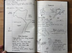
The area I chose for my research project is my local dog park in Victoria’s View Royal area. The city park is approximately the size of two football fields or ~2-3 acres. The dog park makes up about 2/3 of the total park. It is a flat field with few leafless, planted, deciduous trees in the center and various wild shrubbery surrounding it. On one side there is a man-made ditch to collect rainwater and on the other side, separating the dog park field and the rest of the city park, there is a slow-moving stream which is approximately 50 feet wide at its widest and 3 feet at its narrowest. The field itself is flat and contains only green grass and clover weeds but the edges are home to various large coniferous trees and various shrubbery. Around the park, there is the stream with high, steep embankments which drastically slope down into the water. The water itself is brown in colour as it picks up mud from the banks moving through the park. Around the banks are large trees and thick shrubs which hide the view of the stream.


When you leave the dog area of the park, there is a slightly hilly field containing a child’s play area and old, large trees, like the ones surrounding the off-leash field, scattered around approximately 10 feet or more from each other. Surrounding the park on the opposite side from where the dog park is there are row townhouse homes. Many young families live here and are often outside in their yards even in the winter. In the northeast part of the park, there is an island of vegetation in the open field. It contains a douglas-fir and another type of western coniferous

I visited this park today at 14:00, it was a sunny, moderate winter afternoon at approximately 10°C. This weather is warmer than a usual Victoria winter day. There were a few humans accompanied by large dogs. There were two children on the playground. The wildlife observed were small birds, a rabbit and at least two squirrels. The birds were found in one group and were small and mostly brown. There were approximately 20-30 of them flying between a bush and a group of deciduous trees in the west corner of the park. The rabbit was seen near the road at the entrance of the park it was also brown. The squirrel was seen on a large coniferous tree near the children’s playground.

Observations

In my observations, I noticed that there are no observable prey animals (squirrels and rabbits) near the off-leash dog area compared to the many squirrels which inhabit the trees surrounding the area of the park where dogs must be leashed.

The plants surrounding the off-leash area seem to be native plants whose growth is not disturbed by landscaping efforts by the city unlike within the field which is mowed grass and hand-planted young trees.


The ditch on the north side of the park is man-made and contains stagnant, rainwater; which, if full enough, empties into the natural stream.

My Field Notebook Drawing


Blog Post 1

On December nineteenth 2018 I went to the Marshlands Conservation Area in Kingston Ontario. It is located west of Queen’s University and Kingston Penitentiary stretching just shy of Lake Ontario (southern extent) northwards towards Princess Street (main street leading you to the downtown hub if you head east along it). The conservation authority is wedged between the Cataraqui Golf and Country Club to the east and the Little Cataraqui Creek to the West (for most of the property). The vegetation in this region includes woodlands, wetlands, and commercial lands (roads or private property). The Conservation Area is relatively low lying than surrounding land because it’s proximity to water. It does not have drastic changes in elevation.

https://crca.ca/wp-content/uploads/PDFs/maps/Marshlands.pdf (map of Marshlands Conservation Area)

I arrived at the site around 2 p.m. in the afternoon. The temperature was 3 degrees Celsius with broken cloud cover in the sky. The temperature was slightly warmer than average for December but there was no snow cover since there had been little precipitation of any kind in the previous week.  I walked along the Rideau Trail up until it intersected with the train tracks before heading back. On my walk I noticed that some of the butternut trees and ash trees had large fissures in the trunk and some were leaning to one side or have already fallen over.

Figure 1: Field Journal

Figure 2: Rideau Trail

Figure 3: Leaning Tree

Figure 4: Damaged Trunk


I’m interested in answering the following:

-What effect do emerald ash borer and butternut canker have on recreational trails?

-What are the ecological costs and benefits to removing those hazard trees and potentially reforesting the area?

-Can the risk of further infection to other trees be mitigated in any way?

Blog Post 1

The area that I have chosen to study is a boreal forest behind my home near Toronto, Canada during the month of December. I frequently walk through a man made pathway that goes over slightly steep hills that span the forest. Since it is December, the temperatures are cold and snow is covering the ground of the forest. Leafless white birch, balsam poplar, and trembling aspen as well as many different types of conifers such as black and white spruce, jackpine, and tamarack are abundant during this time. I’ve also seen lichens, shrubs, and mosses. Much of the area is forested and there are a few bogs as well. The animals that I usually see during the winter are squirrels, rabbits, birds, but I have heard of others seeing deers and wolves as well. The potential subjects that I am considering for this project are coniferous trees since they are the most abundant during this time of year. One idea that would be interesting to study is to see if elevation has an effect on the abundance of coniferous trees since they prefer dry, arid conditions and there are many hills throughout the forest. I could compare the abundance of conifers in bogs compared to other areas in the forest. I could also take a look at the types and abundance of animals as the elevation increases.

Post 1: Observations

The area I have decided to to observe is the Sonoran desert scrublands around Scottsdale in Arizona, USA. The area is quite large comprising about a quarter of the state (~74 000sqkm) although I will be observing a conservative amount of the area at around a square kilometer. The topography is flat, sandy scrubland with occasional stand-alone mountains jutting out of the ground. The vegetation is comprised of mostly succulents and small, shrub like trees. The density of this plant life is quite sparse, with large amounts of dust and sand between any two individual plants forms.

As I am visiting the area in winter, the weather and temperature are quite temperate. The day of observation saw partially cloudy skies and a max temperature of 17 degrees celcius. I spent the largest amount of time observing Papago Park at about noon to 3pm.

I am most interested in seeing whether vegetation cover improves closer to the man-made waterways that go through the park, whether the mountains themselves affect vegetation (by providing shade or alternative rocky substrate) and whether or not the mountain caves provide shelter for different kinds of vegetation or animal life relative to the open Sonoran scrublands.

Elevated view of the open scrublands.
The type of mountains that appear in the scrublands.
Man-made waterways that supply water to the region.

Observations

The Area that I have chosen is a inner city park called Canmore park located in Calgary. The area is approximately 15 hectares in size, and is a mix of grassland rolling hills and large groups of deciduous and coniferous trees. There were some magpies noted in some of the trees, as well as some animal tracks in the snow that appeared to resemble those of a rabbit or hair. Squirrels were noticed to be in the trees.


At the time of my field outing the weather was sunny clear skies and was -2 degrees Celsius. This area is a well-used park by many people in the community for cross country skiing and walking dogs. This time of the year the ground will be consistently covered in snow and ice and the majority of the trees will not have any leaves on them.


From my observations this day I noticed that despite the number of trees in the area there were not a lot of birds. I constantly have birds in my back yard year round. I would like to investigate the effects of urbanization and housing development of bird feeding and nesting habits when comparing this city park to urban city dwelling environments?


The other thing I noticed is that this area has signs of coyotes living in the area, but there are few other signs of food sources for them. How do coyotes in inner city neighborhoods thrive with lack of readily available food source?


As well I noticed that there were human tracks throughout the park, but there was distinct lack of activity in the more densely treed area of the park. Despite there being pathways through this area. In city parks such as this do residents preferer to walk in grass land areas as oppose to treed areas?

Post One: Observations: Cates Park

The region I’ve chosen to study is Cates Park, a North Vancouver District municipal park. It is also known as Whey-Ah-Whichen, “Faces the Wind,” by the Coast Salish Tsleil-Waututh Nation, whose territory the park is situated.

📷Perimeter of Cates Park, courtesy: Google Maps

I first visited Cates Park for this study on Wednesday, November 28, 2018, at 1530h. The weather was overcast with light rain and no wind, so the sea state was flat and mirror-like. It was 8°C in late fall, and the tide was ebbing until 1640h, but this low was only 3.1m. Tidal variances in this area can be as high as 5m, but today the change was only about half a metre.

📷Looking east towards Port Moody Inlet, at the Roche Point flashing marker and layers of kelp at various tidal levels along the beach

Cates Park offers an ecosystem to which I am familiar, so the subsequent field observations will allow time and attention to more thoroughly analyze the Coastal Temperate Rainforest and its interactions with the sea. Other points of interest in Cates Park include Coast Salish cultural and environmental history, that Whey-Ah-Whichen is one of a very few seaside parks along the busy, industrial Vancouver shoreline, and is directly across the Burrard Inlet from an oil refinery. Local current events include ongoing environmental protests to stop an expansion of a pipeline that ends across the inlet. Tanker traffic is reported to increase 7 fold.

📷A tanker is escorted out of the Burrard Inlet

Whey-Ah-Whichen is a point of land at the meeting of the Burrard Inlet, Indian Arm and Port Moody inlets, with approximately 60 acres of forest, sandy and rocky seashore, and trails. To its north lies Dollarton Highway, a coastal road towards Deep Cove. The park is influenced by human factors, as visitors walk dogs and picnic with family, kayak and beach comb, and vehicles pass by both along the road and the waterway. The trails are maintained and occasional stairs lead from the forested pathway about 2-5m down to the beach.

The beach is composed of sand, rocks, pebbles and shell midden in some areas, and rises a few metres to meet the forest. A variety of kelp found on the beach include rockweed, turkish towel and sea lettuce. The forest has a gradient from the more sunlit seashore to shadier inland, including shrubs (red huckleberry, salmonberry, salal, wild rose, blackberry, common snowberry), trees (red alder, black cottonwood, broadleaf maple, western hemlock, western red cedar), ferns, grasses, mosses, lichens, bracket fungus, dandelion and ivy. There is a small freshwater stream halfway along the Malcolm Lowry trail and it dischargers on to the beach.

📷Field Notes pg 1
📷Field Notes pg 2

In terms of wildlife, sightings were sparse. Barnacles are abundant, and I expect to see more intertidal life closer to the new and full moons, where there will be more tidal exchange. I’m looking forward to spotting sea stars, shore crabs, harbour seals, small mammals and birds of prey in the future.

📷Barnacles abound

Potential Study Subjects:

Nurse logs are abundant on the coast, as trees that have either fallen or were logged support life for new seedlings. They decompose very slowly and allow their hosted trees to grow for decades and root around them. What nutrients do nurse logs provide, how much of a carbon sink are they, and which plants tend to use them more often as a bed for new growth?

📷Two western hemlock trees encompass a nurse log stump, with buttress roots that cascade toward the ground


Sea stars are a keystone species and top predator in their ecosystem. Recently their populations were devastated in a mass die-off from sea star wasting syndrome. Are there sea stars along in the intertidal zone of Whey-Ah-Whichen, do they show signs of the disease, and to what extent? How has this impacted their prey and other features in the intertidal zone?

The forest along the coast has evolved to thrive next to a salt water environment. What nutrients are brought from the currents of the inlet, how well do trees and shrubs thrive next to the ocean versus inland, and to what extent does the extra sunlight beside the beach help mitigate effects from salt or storms of the sea?

📷Western red cedar branches hang over the seashore


Coast Salish people have used this area for centuries, their culture thriving on the abundance from the ocean and the forest. Are there any culturally modified trees in the park, what portion of the tree was harvested and how well do the trees recover after bark or wood is taken? What food and medicine plants are in the park, and how have these been distributed by the Tsleil-Waututh cultural practises?


Post 1: Observations

Danielle Kinsella, November 16th 2018

The area I have decided to study falls within the Garry Oak ecosystem at Pipers Lagoon Park in Nanaimo, BC. My reconnaissance of the area was November 11th 2018 at 2:55 pm. The weather was sunny with a bit of wind, the temperature was a warm 8°C fall day.

The landscape consists of a tied island attached to Vancouver Island by a ~350m long tombolo. The tied island is 275m long in the NW/SE by 200 m NE/SW (see Figure 1). Together, the landforms create a large lagoon which undergoes drastic water level changes every day with tidal movement. The north side of the park consists of rocky bluffs, however, elevation does not exceed 20 m (see Figure 2). The tombolo has relatively flat topography, while the east side receives direct waves.

Figure 1: Satellite image of study site. Green outline indicates the park boundary and extents. Created using Google Maps.

Figure 2: View of Pipers Lagoon facing North.

The area ranges from forested areas, grasslands with scattered trees and shrubs, to intertidal zones with dense aquatic vegetation. There are a variety of vegetation species within the park, however, the only animals sighted were ducks, geoducks, seagulls and a bald eagle. Along the tombolo is largely grassland with shrubs, with a few Garry Oak and young Arbutus trees. The main portion of the park is forest consisting of mainly Garry Oak, Douglas fir and Arbutus trees. Several shrubs occur along the forest floor as well as some invasive species such as Himalayan Blackberry and English Ivy.

Possible Subjects and Questions

1. What daily fluctuations do the organisms in the intertidal zone undergo each day and how does it affect their internal nutrient composition?

Identifying and studying the species located here, you can determine their relative abundance. This method of analyzing the community may indicate which species is more adapted and able to survive harsher conditions. Another possibility would be to analyze the salt content in different species of plants.

Figure 3: left photo: sea asparagus, right photo: below surface geoducks.

2. Are the invasive plants a threat to the keystone species in this ecosystem? Do they affect all other vegetation species surrounding them?

While observing the Garry Oak tress I noticed along the ground some Himalayan Blackberry plants. They were growing between a young and old Garry Oak (see Figure below), and nearby was a juvenile arbutus tree. English Ivy was also observed along the floor of more dense forest, where it slowly crept up Garry Oak and Douglas fir tree trunks.

Figure 4. Left photo: Invasive species near Garry Oak. Right photo: young arbutus found nearby.

3. Does the spatial distribution of tree species vary along the perimeter of the tied island?

The north side experiences direct wind from the ocean, whereas the south side is protected from harsh winds and does not experience harsh waves. Also, the north side is rocky bluffs where it is too steep for several trees to grow. Are the two areas affected differently by sunlight and/or the physical environment surrounding them, and does it affect which tree will grow there? The three distinct tree types are: Garry Oak, Arbutus and Douglas fir. Walking around the park it appeared there were many places with only a single tree species, or with several.

Figure 5. Left photo: Southwest side of tied island. Right photo: Rocky bluffs on North side of island.

Figure 6. Trees growing out from rocky hill. Left photo: Garry Oak. Right photo: large Arbutus tree.

Figure 7: Young Douglas-fir tree.

Field Notes:

Ecology Blog Post 1

Observations of Study Area:

The area I have decided to observe is Art Gibbon’s Memorial Park. Art Gibbon’s Park is a wooded, flattish city park in Nelson BC. The park is rather large around the size of one and a half football fields.  at the top of the Rosemont neighbourhood, a neighbourhood that spreads over the side of a large hill at the top of town. The park is mainly covered by large trees that appear to be Cedar, Hemlock and Douglas Fur for the most par. Under these large trees there seems to be minimal undergrowth present. There are a few patches of smaller, thinner white trees, and where they grow the floor is carpeted in moss and small plants. There were minimal signs of fauna present, the park was quiet with no birds nearby, and only a few glimpses of squirrels off in the distance. I visited the park a few times since the 1st of October at 10:00am, 12:00pm, and 5:00pm, in both cloudy and sunny weather.

Questions:

  1. Is there a difference in soil quality between areas of new growth and area’s with the established canopy?
  2. Are there patterns in the distribution of the different species of trees due to competition?
  3. How does snow fall interception relate to the species of trees

Blog Post 1 – Observation

In the city, green spaces tend to be limited. Luckily, my apartment’s backyard is one that I could only dream of as a renter. I live on the ground floor of a 5 story apartment building. My apartment has a small, fenced patio which faces a shared green space between all the tenants.

Behind the green space, there is a beautiful path that leads a very large forested area (large for being in the city). In that forested area, there is another path that goes on for kilometres, winding through the trees, following a river. Very close to home, in the forest, there is a 2 square km area that I’ve been conveniently using as an off leash dog park. It is a place I go to almost every day. This is the area that I have decided to observe for this experiment.

I call it the peninsula in the woods, which is very accurate. It is an area that is surrounded by a river and is only connected to the land by one very small portion. The best way to describe it would be “wild”. There are as many live, healthy trees as there are dead ones. It seems that the main beings tampering with the land are deer, carving random trails through the brush, laying down and leaving concentrated spots of flattened grass. There are broken branches scattered everywhere. I’ve observed two areas where humans may have been recently. The first one being a couple of wood planks nailed to a tree, a possible tree house in the making? However, it hasn’t changed in a year. The second being a couple of large tree trunks laid down horizontally surrounding an area where there seems to have been a fire pit at some point. Once again, this place hasn’t changed in a year. Vegetation of all sorts can be found here. I’ve seen various types of moss, tall grasses, small bushes, large bushes and trees of all kinds. I would have to spend some time specifically to identify the vegetation, it isn’t my forte. I have seen many beavers in the water. There is a dam in the river that’s been flooded. That dam was built over the summer. As well, during the night, it is very common to hear coyotes howling nearby. Almost too close for comfort. It is precisely the reason why I don’t let my cat out in the night.

Potential Subjects:

  • As the cold temperatures arrive, the shallow river will begin to freeze. It could be interesting to try measuring wildlife activity as it gets colder. I could walk through and note all the signs of animal activity. Then, over the next while keep track of any changes in the ecosystem all while keeping in mind the temperature.
  • Moss has always been an interesting topic for me. It is said that moss grows on the north side of trees. I have always wondered if that was true. This could be a great opportunity to go through and record the location of moss on trees to see if it demonstrates accurately the cardinal points.

  • Just by listening to them, it seems the coyotes are dangerously close to the buildings. I would like to find out how daring they actually are by tracking them and finding the closest signs of their presence. With that, I could search the peninsula, but also other parts of the forest surrounding my building. I could look for feces, fur, tracks, etc.


Post 1: Observations

I have decided to observe three different areas in nature, and compare them in different aspects. The first area is forested, mainly with coniferous trees and moss, it is an inclined slope of a hillside. This is located in an undeveloped area of Juniper West in Kamloops, B.C. The second area is flat and dry containing mainly sagebrush. This is located in an undeveloped area beside Highland Drive leading up to Juniper in Kamloops. B.C. The third and final area is a marsh strip of land that has a stream leading to it. The vegetation is mainly tall grass and cattails. This area is located in Kenna Cartwright park, a municipal park located in Kamloops, B.C. I have visited all these areas from various walks and hikes in August on a sunny day. It interests me to see a potential reason for the vastly different growth of plants in different natural areas of one city. This could be due to the soil, elevation of the area or amount of available sun. The three questions I formulated from observing these three varying areas include: What aspects of the soil have the greatest effect on the vegetation growing in an area? How does the elevation of an area affect the vegetation that grows there, or if it does at all? All areas seem to have different levels of moisture, how different are the levels of moisture in the soil? And consequently how this affects the vegetation.