Blog Post 1: Hay River, NT

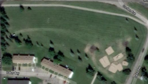
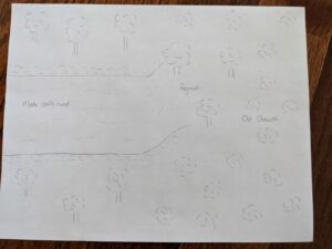
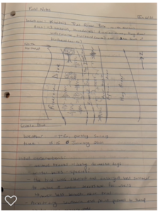
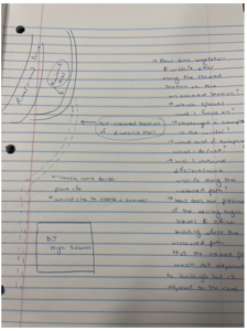
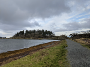
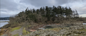
The site that I chose for my field study is an area along the bank of the Hay River in Hay River, Northwest Territories. The river park extends for about 2.2km from the Vale Island Bridge to the local high school. I chose an approximately 1.5km long by 50m section of the park to focus on for the study. The northern border is demarcated by the northern trailhead entrance near my house. The eastern boundary includes the Hay River watercourse, which is currently frozen in a thick layer of ice. The southern boundary is the end of the trail which leads up to the parking lot of the Power Corp office building. The western boundary is demarcated by Riverview Drive.

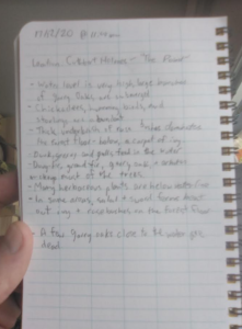
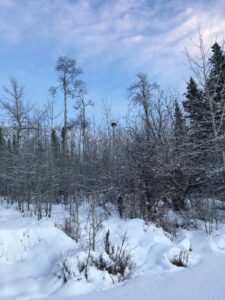
My initial site visit was conducted on January 6, 2021 at 15:15. It was partly sunny and -7 degrees Celsius. The day was particularly warm for this time of year, as average temperatures have been hovering around -25 degrees. The area is heavily snow covered; a full visualization of flora and fauna was limited.

This area would be classified as a town park bordered by residential zoning and is comprised of riparian and woodland areas. Through the park runs the Kiwanis Trail, a walking path that was enlarged in summer 2020 to make it more accessible for walkers. This included clearing brush from the sides and packing down dirt on the trail to make it a more even surface. A section of the trail which runs behind the high school and then up to the Power Corp was not enlarged or cleared and has been left to become overgrown with plant life and fallen trees.

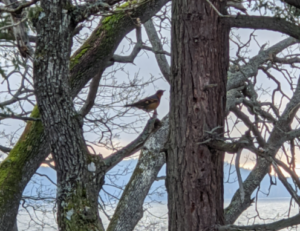
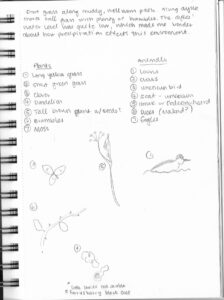
The park contains a lush array of woody trees, shrubs, brushes, grasses and flowering plants. On the eastern side, the riverbed has a steep eastern facing slope covered with brush, shrubs, and flowering plants. This steep slopes levels off to the river bottom below and the frozen Hay River. In the spring through fall, I have encountered a variety of wildlife in the area including sand hill cranes, groundhogs, squirrels, various birds, black bears and lynx. On my winter site visit I observed only one brown squirrel and a few small brown birds.

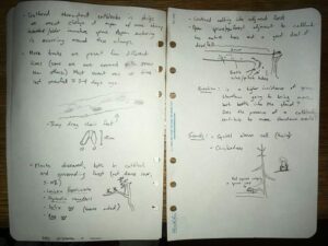
Upon exploring the area, I developed four questions which will act as the base for my future study and analysis of the area:

  1. Did the widening of the Kiwanis trail (including removal of brush) impact wildlife biodiversity and habitats in the area?
  2. Does biodiversity and wildlife behaviour differ between the cleared section of trail and the trail left intact?
  3. How did summer 2020’s record high water levels impact the vegetation, slope stability and wildlife in the area?
  4. How will the area change through the seasons? This includes migration of species and growth of plant life in the spring.

Blog Post 1: Field Observations

Field Observations – Matthew Peterson

The area I have chosen for this study is Pipers Lagoon, located in Nanaimo B.C. I visited the area on January 9th at approximately 9:40 am. The weather was mainly cloudy with a few sunny breaks, ~4 degrees in temperature, and fairly windy. Low tide in this area had occurred at 7:39 am.

The entire park area is approximately 8 hectares in size and consists of a tidal mudflat (the lagoon), an approximately 300m long tombolo or sandy isthmus, and a rocky headland or tied island. It is a well-visited site year-round, with a somewhat rugged trail system that loops the entire tied island. Elevation change is approximately 20m (according to alltrails.com) between sea level at the tombolo and the high point on the tied island.

The tombolo which has a relatively flat topography and predominantly grassy vegetation connects the mainland Vancouver Island with the rocky headland or tied island. The eastern side of the tombolo is exposed to the open ocean, consists of an abundance of dunegrass, and has a predominantly pebble-sized substrate. The Western side which is exposed to the lagoon waters generally lacks dunegrass but has an abundance of various other smaller-sized grasses and has a much smaller and finer substrate. 

Figure 1: Looking North Towards Tied Island Along Tombolo

The lagoon itself undergoes daily tidal fluctuations but was pretty well entirely underwater when I arrived. The tied island which is approximately 5 hectares in size consists of multiple rocky outcrops where various lichen, moss, and broad-leaved stonecrop were observed. The smaller rocky outcrop was dominated by mainly Garry Oak, with a couple small arbutus also observed. The main tied island had a variety of vegetation including Ocean Spray, Nootka Rose, and the invasives Spurge-Laural and English Ivy. Tree species observed here were Douglas Fir, Garry Oak, and Arbutus. The northern, exposed portion of the tied island was dominated by Douglas Fir, while the south-facing side formed a typical Garry Oak ecosystem, with Camas known to bloom here in the Spring.

Figure 2: Garry Oak and Douglas Fir on Tied Island

The area is well known for birding and I was fortunate to observe several species including Mallard, Bufflehead, Glaucous-Winged Gull, Bald Eagle, White-Crowned Sparrow, Black Turnstone, and a Varied Thrush.

Figure 3: Varied Thrush in Garry Oak


Potential Study Questions

Based on my initial field observations here are three questions that may form the basis of my study.

Question 1: Does exposure to salt spray determine the abundance and distribution of the Broad-Leaved Stonecrop?

It was noted that the stonecrop was generally found along bluffs exposed to the ocean as opposed to the lagoon.

Question 2: Does the difference in substrate composition of the lagoon compared to the beach (on the other side of the tombolo) impact species diversity?

Although the tide was up fairly high I imagine the species diversity between the lagoon and the beach area must be at least somewhat impacted by the substrate.

Question 3: Do the tree species composition and diversity change from mid tied island to the perimeter with sun exposure?

It was noted that the majority of Garry Oak on the tied Island were concentrated on the more southern facing side, while the Douglas Fir was denser in the north direction.


Field Notes:

Blog Post 1: Observations

I’ve had to change my location, so this is an updated observation. I choose to pick a bigger location closer to my house. I decided to pick a length of the dyke along a common road in Surrey, BC. The length of the dyke is about .6 km. I choose this location due to the about of wildlife and components of the environment along the dyke. The top of dyke A (dyke B is running parallel) is well worn, but always a quiet dyke in comparison to dyke B. The two dyke paths are separated by a large canal of water, about 15 feet across. There is a combination of tall yellow grass and brambles that make it difficult to venture down to the canal, but entirely possible.

As it was a clear day, there were plenty of animals out. I heard several hawk or falcon calls, crows in the surrounding trees, some human traffic from the nearby roads, construction from the nearby complexes and a tractor in the blueberry field on the right side of dyke A (if facing SE). There was evidence of animals from the scat along the trail, paw prints in the mud, ducks and a few loons swimming in the canal and crows flying overhead.

There was plenty of plants that I was not familiar with. Brambles along the shoreline, tall yellowing grass on either side of the dyke, green short grass along the trail with spots of clover and dandelion weeds. Mixed into the tall yellowing grass there were brown tall plants with seeds and dying flower heads of some sort. I was not familiar with them, but they might potentially be thistles.

Overall, it was a great first observation of this location. I have many things to ponder about how to create my hypothesis and test it out.

A few questions I had:

  1. How does precipitation effect the dyke’s ecology system?
  2. Does the dyke water levels rise and fall frequently?
  3. Are there bugs and fish that I was not able to observe?
  4. How does the blueberry farm effect the dyke?

I’m looking forward to returning, observing the nature another day, and answering some of my questions. Below are some of my field notes from my adventure.

Blog Post 1: Observations

The area I have chosen as a field site encompasses roughly 50 hectares of land and lakeside in the Lakes District approximately one hour south of Burns Lake BC. It is located within a couple hundred meters of a relatively small lake called Bickle lake and is partially on private land (permission to access granted) and partially on crown land designated as “Old Growth management area” by the Province. The ecosystem classification of the entire site as per BEC-web is Sub-boreal Spruce dry-cool (dk) with some site series variation. Slopes are minor with some short steep sections directly adjacent to the lake. My area of interest will likely become smaller as I refine my research question but for now I’m looking at several environmental gradients. These include two particular areas which I will describe in the following paragraphs documenting my initial site visits.

The first area was visited on January 4th, 2021 at around 4:05 pm, accessed by cross-country skiing on the lake. The weather was clear, sunny (sunset) and the temperature was around -1 degree Celsius.   Located on a promontory of the lake south of the private property, this section of forest is within the Old Growth Management Area (OGMA) (iMap BC) and has forested lakeside edges that are both north, west, and southwest-facing. Along the north aspect the stand contains large-volume spruce with a good deal of blown-down dead pine (most of the pine in the area was killed by the Mountain Pine beetle epidemic in the early 2000s), which gives way to younger spruce towards the point of the promontory, and then an open aspen-leading stand on west- and southwest facing slopes. I saw old moose prints on the lake and the willows along the shore were browsed so heavily they looked spiky, though the interspersed alder was not browsed. I saw and heard several ravens flying by, but saw no other live animals. A large raptor nest (known from previous summers to be bald eagle-made) was located at the top of a tall aspen
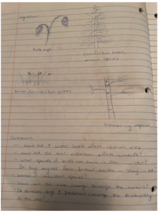
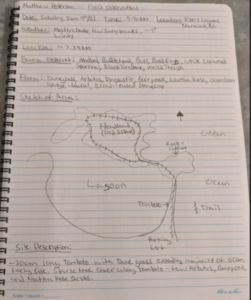
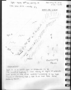
, and I saw a cavity nest on an aspen snag at the point of the promontory.

The second area was visited January 7th, 2021 at around 9:05 am, accessed by snowshoe. The weather was calm, partially cloudy, just after dawn and approximately -9 degrees Celsius. Located within the private property north of the OGMA, the site is on the edge between a partial-harvest clearcut (logged circa late 1990s) and the mature mixed forest directly south of it which leads down to Bickle lake. This clearcut is undergoing natural reforestation (it wasn’t planted) and the lakeside is also undergoing a succession process as it was heavily influenced by beaver activity 15-20 years ago. I walked through moose tracks that were left days ago as well as weeks ago. I noticed how spruce and aspen regeneration was occurring in a patchy manner, with dense heavy clumps and strips scattered between sparser strips. Within the adjacent forest were places where criss-crossing immature spruce blowdown cluttered the forest floor, as well as places where larger spruce and aspen had fallen. Was this just natural forest disturbance? Was it related to the “edge effect” of the clearcut? Or could it be that the wind events that have been occurring have been more severe recently? (Due to climate change?) As I walked into the mature forest I felt, saw, and heard the presence of more animal life. I watched a squirrel munching on spruce cones (and it watched me) and heard several squirrel alarm calls. I heard chickadees calling; and I followed the tracks of a small canine – probably red fox. I noticed a large opening with blown-down trees with 5-6 scattered trees broken off at around 5m, some live, some dead.


Field observations
Observations of moose tracks, browse, and squirrel

Three initial questions come to mind regarding my observations:

  1. Why is there an apparent difference in tree species concentrations on different aspects – even within a small “old growth” area? What ecological attributes form the basis of a designation such as “old growth management area,” and can these attributes be measured in differently organized forest stands? (e.g. open aspen stands with heavy saskatoon/snowberry shrub component as opposed to a high-volume spruce stand)
  2. Does the heavy density of coniferous regeneration that appeared to naturally return to a harvested site – similar to the super-heavy pine ingress I’ve observed following a forest fire – provide some sort of stand resilience or biodiversity advantage as succession progresses? I’m comparing Nature’s method of succession to the Industry standard of an evenly-spaced tree crop.
  3. The heavily browsed forage species I observed at first made me question whether there was inadequate browse options to support the local moose population but this goes against local anecdotal evidence which suggests moose populations aren’t at over-capacity. Also, upon further observation, there appeared to be plenty of browse species individuals that were hardly touched by moose. Could plant individuals that were hyper-browsed simply be located in moose thoroughfares and were thus casualties of being “along the main trail?” Or could there be some strategy at play to produce more new shoots on one plant individual, thus decreasing a moose’s need to travel further than otherwise?

Blog Post 1 – Observations

Observation Area and Topography

The area I have selected to observe is a 1 km2 area in Western Ukraine. The area has been chosen primarily due to its accessibility, multiple environmental gradients and its densely populated communities of various animals. The land consists of a gentle sloped hill descending from south to north with a shallow creek bed and stagnant pond on the western aspect, I have been in this area throughout every day for the past few months so it is easy to observe and document daily and hourly changes and behaviors on a regular basis.

Map of Observation Area

Vegetation

Most of the area consisting of mixed temperate forest, creeks and swamp blending into an urban park with some permanent buildings. The forest consists of primarily mixed types of pine and large old growth oak. The forest floor is a mix of smaller plants and shrubs but is clear enough in most places to walk under the trees without becoming entangled in the brush. Among the scrub brush there are poison ivy plants. In lower areas near the ponds the undergrowth becomes almost impassible with various types of bush like plants such as raspberry. These are fed by the higher water concentration in the thick black soil. The urban area is sparsely populated by cypress, old growth oak and pine trees that initial grew prior to the laying of brick paths between the buildings. The grass, likely a human addition, has grown over a grey sandy soil, in the urban area is maintained once every month or so, but is mostly left untouched unless it is tall enough to go to seed.

Drawings from field journal

Wildlife

There are a number of animals who live in the area. Rarely seen is the Red squirrel, (Sciurus vulgaris) populates the trees, while the moles are predominantly in the sandy area of the urban grass. There are many feral dogs which roam far and wide as new packs enter and exit the observation area as food or mates become sparse. A smaller number of different coloured feral cats (likely not from the same litter) stay in the area to prey on the mice, birds, squirrels and the occasional mole. Of note the only birds seen are seagulls, which have left the area due to winter, and the yellow Parus Major which flits around between the worm rich ground and the thick cover of the cypress and pine trees. Some of the feral dogs have had visibly engorged ticks on them as well. There have been no turtles nor fish seen in the pond but it is not well oxygenated by plants, as it contains a great deal of decomposing leaves from the deciduous trees and very little movement from the tiny creek.

Weather

From October to January the weather has transitioned to cool fall to mild winter. Short periods of light rain showers, and a persistent overcast winter sky are rarely disturbed by any significant wind greater than what could be described as a breeze. Despite the winter season the weather here is mild enough for the temperature to range between an average of -5oc at night to +10oc during the day. It has only snowed three times, and it rarely lasts longer than a day or two before melting away.


Questions

  1. Since none of the dog spoor has been seen anywhere in the area, where do the feral dogs defecate? Is it a centralized location?
  2. The moles appear to continue pushing upward and creating molehills, but I am curious if there may be a correlation between soil temp and activity and or the activity of the prolific earthworms?
  3. Does the predation of moles by cats and dogs effect the location of the mole colonies?

Blog post 1

The area that I have chosen to observe is a small city park near my house that is used by both humans and animals, as there is a large open space as well as a playground. I visited the area on Dec 29th, 2020 at 16:00. The temperature was -7 C˚ and the weather was cloudy with a breeze, 4in of snow covered the ground. The park is situated on the side of a residential neighborhood in Brandon, MB. The park is mostly open flat grassland with trees growing in some areas. The size of the park is approximately 400m in length.

The vegetation within the park is open grassland with no shade and no trees, areas with larger trees that provide shade, and smaller trees that were sparsely spaced out. Additionally, it is located by city streets and railway tracks that open up to the rural areas and allow animals such as deers and wild rabbits to roam the residential roads.

3 questions that could form the subject of the project

  • How does the proximity to a residential area affect the species diversity and richness?
  • What habitats are usually used by deers?
  • What biotic/abiotic factors attract these specific animals to the area?

Blog Post 1: Observations

I have selected a section of Cuthbert Holmes Park in Saanich as my area of study. Cuthbert Holmes is a municipal park, under the jurisdiction of the District of Saanich. The park itself is around 26 hectares, but the area I will focus on (referred to as “The Point” on park maps) is around half an acre. It is a relatively flat estuary abutted by a young forest. This park stands out to me for two reasons.

First, it marks the headwaters of Portage Inlet, an urban estuary which runs through the Capital Regional District. Portage Inlet and the Gorge Waterway are host to a wealth of urban wildlife. This section of Cuthbert Holmes Park stands out for it’s mudflats, a brackish marsh area which marks the transition from freshwater stream to estuary. Currently, the mudflats are almost entirely flooded, which as I understand happens seasonally. Previously, the area was home to Vancouver Island’s largest blue heron rookery (https://www.saanich.ca/EN/main/parks-recreation-community/parks/parks-trails-amenities/signature-parks/cuthbert-holmes-park.html), and although the birds are not currently nesting here they still use the park’s waters for feeding.

The second reason this location stands out to me is its history. Previously under industrial and agricultural tenure, the area has been restored in the last few decades. This includes the salmon habitat of Colquitz Creek, the waterway which flows into Portage Inlet. I would like to take the opportunity to observe how this park continues to rebound post-restoration. The portion of the park I have chosen to focus on is right on the margin of development: on one side of the mudflats are residential backyards, while the other side is young second growth coastal douglas-fir forest. The invasive Himalayan blackberry (Rubus armeniacus) and English ivy (Hedera helix) have overtaken the margins and the understory of the area, respectively. Some grand fir (Abies grandis), arbutus (Arbutus menziesii), Garry oak (Quercus garryana) and many douglas-fir (Pseudotsuga menziesii) make up most of the tree species in the adjacent forest.

I’m visiting the park with ecological observation in mind for the first time today, December 17th. It is late morning on a relatively warm, sunny day.

Potential questions to explore:
-The Saanich website claims that bald eagles are to blame for the disappearance of blue heron rookeries. What other factors might be keeping blue herons from nesting in the area?

-In the areas overrun by blackberries and ivy, what effect are invasive species having on the overall species composition? Do these effects ripple down through different trophic levels?

-Garry oak are a drought-adapted species of tree. The Garry oaks at the edge of the water are subject to seasonal flooding. I wonder if these trees established at a time when the mudflats were drained for agricultural purposes. Is it possible that the Garry oaks situated below the flood line are less fit than the trees which are not exposed to seasonal flooding? Are these trees ultimately destined to succumb to flooding stress?


Post #1: Observations

The study area I will be examining is located in an urban neighborhood in Lamar County near Hattiesburg, MS. The area I have selected includes a cleared section that was covered in red clay and sand to create a makeshift road, a partially cleared forested area where the soil is a mixture of transported sand and native soil to the area and regrowth has taken place, and an old-growth section that was not influenced by anthropogenic means during the creation of the road.

My observations began in a section that had been cleared and made into a small road that transitions from sand to concrete-like red clay. In this area there is no vegetation, however, I have found deer, raccoon, and bird footprints in this section. The red clay road makes a small incline into a semi-cleared forested area where the soil has a mix of sand from the road and native soil. Since being cleared regrowth has begun to form where the road was. This area transitions into a more heavily forested area where only natural clearing has occurred. 

I visited the location on October 18th, 2020, it was 11:30 local time and there were few clouds splattering the sky. It was 28 degrees celsius.

Notably, the plant diversity and richness varies over the gradient from the transition of the sanded road to the forested area as well as the size of the plants. Additionally, I observed that the presence of animals was more pronounced on the sanded road where the sand could capture tracks than in the treed area where animal presence was more easily disguised. 

Questions of interest I had included:

  1. Are the types of plants in the different gradients all native or are any of the plants invasive to the area?
  2. How do precipitation and sunlight impact plant growth in each of the different areas?
  3. Will the edge of the old-growth area influence the speed and types of species that grow in the regrowth area?
  4. Which area is more likely to have the largest Are animals more likely to be found in the old-growth area where there is less anthropogenic activity than on the sanded road?


Below is a drawing of the observed area:

Figure 1: Illustration of observed area including makeshift sanded road, regrowth area, and old-growth area.

Post #1: Oberservations

The area that I choose to study is the lakeshore area of Toronto, more specifically the little park across my apartment. This park and trail is thin and lengthy spanning over many kms. I will just be analyzing the area of the park that is closest to me. It is located beside a major roadway. It is flat with some rolling hills here and there but nothing major. The vegetation is grassland and city street. The park is regulated by city property. I visit the park every day for the past couple of months; however, right now we are in winter time and the temperature is cold and dry (for the most part). I would like to study the geese that are always at the park, and the squerrels that are present
The questions/ hypothesis
1) What types of habitats are used by Canadian Geese? Which species are present, both biotic and abiotic?
2) Which tree species are used by squirrels? (use point counts in areas with different trees)

Post #1 Observations

The area that I have chosen to observe is a nearby city park called The Bill Reid Millennium Amphitheatre. The area of the park is approximately 200m x 1000m. The landscape and vegetation is nearly flat with some hills, covered mainly with grass and strategically placed trees that line the path ways and act as a barrier from the busy roads that surround the park on two of its four sides. A few single trees are placed throughout the grass field at various points.  It also contains a ravine that runs between the main path of the park and the sidewalk that runs alongside Highway 15, and a pond at the far south side of the park beside a quiet road. The initial visit was done on 15 November 2020 from approximately 6:15-6:50am. It was dark when I first arrived and the sunrise had just begun when I was leaving my initial observations. I believe the temperature was approximately 0-3 degrees Celsius and it was cloudy with various breaks that revealed the clear sky. There was no precipitation. It was about a month before the official beginning of winter so temperatures have been dropping and will continue to drop and the ecosystem has been receiving large amounts of precipitation. Because i will be observing and conducting my study in the winter, there will likely be no growth and little activity in the ecosystem but I would be interested in learning about how the ecosystem adapts to survive the harsh conditions of winter and what patterns might be seen during this season.

Some questions I might consider for my final project include:

How do non migrating chickadee birds acquire energy and choose to expend it in preparation for the winter months?

How do the ducks in this ecosystem behave in preparation for migrating south for the winter? Or, will they?

How do ducks behave socially in the winter months? Are they competitive or cooperative? Why might this be the case?

How does the vegetation adapt or behave to make it through the cold temperatures of the winter?