Post 1: Observations

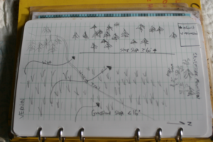
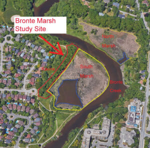
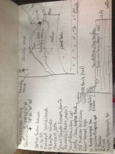
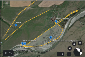
The area I have selected for my project is in Kananaskis Country in Alberta. This area has development of trails, recreation sites and highway 66 going through it. The location I have chosen is the Elbow River boat launch location on the South side of the highway and the Ing’s Mine trail area on the North side of the highway. Highway 66 going through the middle shows quite a gradient in the landscape. Both of these sites are within Kananaskis Country and are designated as Provincial Recreation Areas (PRA’s).

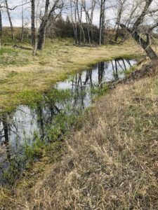
My first visit to this location was on 23/05/2020 at around 13:30hr. It was 7 degrees with wind and low cloud coverage hiding the surrounding mountains. The plants seemed to be in the beginning stages of blooming and the water level of the river was quite high due to spring melt.

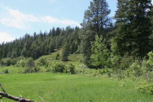
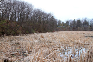
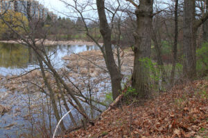
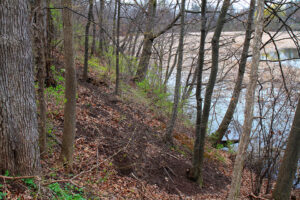
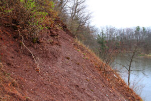
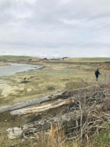
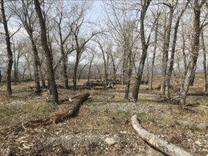
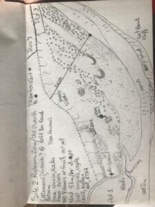
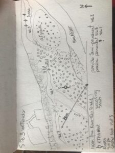
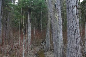
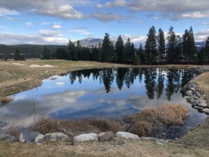
The Elbow River boat launch location had a 500m trail heading West along the Elbow River. On the South side of the river there was a large rock wall. At the end of the trail along the North side there is about an 80% slope that has evidence of rock slides from the floods in 2013, as well as game trails along it. The elevation at the top of the slope was 1470m and it was South West facing at a bearing of 207 degrees. The Ing’s mine trail was at the same elevation on the North side of the highway. The terrain was flat other than the surrounding mountains.

Observed Species:

  • Kinnikinnick (Arctostaphylos uva-ursi)
  • Pine (unsure of species)
  • Birch
  • Bighorn Sheep (Ovis canadensis)
  • Canadian Geese (Branta canadensis) 

I found little variation in tree species and would like to look into whether this is natural or if the area has been previously logged? As well, there were two geese floating down the river with four goslings between them. At what age do the goslings go off on their own? The Kinnikinnick plant seemed very common in this location. What are some limiting factors of this species?

(Kinnikinnick could potentially be subject for research)

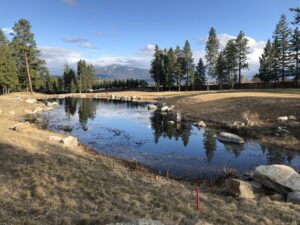
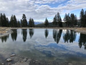
View from top of slope at Elbow River boat launch (South side of highway)

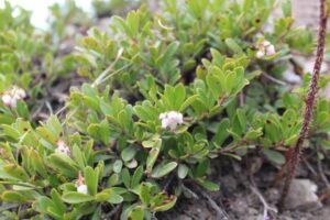
 Arcstaphylos uva-ursi

Blog 1: Observations

The area I have selected for this research project is a transitional zone between a grassland and forest landscape located in Vernon BC. Despite this site being undeveloped and natural it is in close proximity to adjacent property development. I first visited this site on June 6th 2020. It was a sunny 10 degree morning.

The size of the study area is approximately 5000m2 with an elevation of 750m. The slope aspect is East and on a continuous 16 % slope in which the grassland meets the forest. There is also a steeper section of forested landscape that ranges from 60 to 80% slope. It falls within the Interior Douglas-fir BEC zone classification for ecosystems as indicated on iMapBC.

Observed Tree & Shrub Species:

  • Pseudotsuga menziesii
  • Pinus ponderosa
  • Populus tremuloides
  • Pinus contorta
  • Amelanchier alnifolia
  • Symphoricarpus albus
  • Rosa gymnocarpa

Observations:

While comparing the vegetation and ecosystems variance on this site I noticed that the lush grassland was primarily restricted to the more gentle slopes (<16 )where as the adjacent steep slopes (> 60) was an open forest type ecosystem composed of Fd and Py. On another note, I noticed that in the short time I was on site there was considerable mix of complete calm with occasional gusts of heavy wind. I suspect that the topography plays a role in funnelling the wind alongside this mountain. I also found what I assume to be the femur of cow adjacent to edge between grassland and forest as well as a dilapidated wooden structure.

Questions:

  • How does slope and/or site specific weather patterns influence vegetation and ecosystem composition?
  • Do soil properties change between grassland and the adjacent forest ecosystem?
  • Was the grassland at one time pasture for grazing livestock? If so how has that impacted vegetation/soil properties?

Post 1: Observations

Galbraith Mountain is located in Washington State approximately 33 km south from the US-Canada border and approximately 5 km east of the Pacific Ocean (Bellingham Bay). It is a mountainous area of approximately 12 km^2 (3000 acres). The mountain is partially a public park and partially owned by Galbraith Tree Farm LLC (a logging company) and is used for both recreation and logging. The mountain is more of a foothill with 544 m (1785 ft) of elevation gain. There are many peaks and valleys throughout the mountain, which makes it a good place for mountain biking. 

As there is logging there are some areas that are covered in older trees, some areas that have been clear cut and mostly contain shrub-type plants and rocks, and then there are areas where new growth is apparent with straight rows of trees. Many slugs, squirrels, chipmunks, deer, and birds live on the mountain. A mountain lion considers the mountain as his territory, although he is rarely seen and sadly will not likely be part of this study.

Since the mountain is so large, I will focus only on a small subsection focused on the north side, which starts at the end of Birch Street and, for the purposes of my study, ends where the trail Mama Bear starts. The reason for this limit is because it is what I can reasonably cover on a walk and it covers a wide range of habitats depending on what I wish to focus on. 

I visited my chosen area on June 7, 2020 at 15:00. The weather was warm and dry despite the rain last night at 18°C (63°F). It was cool in the shade and there was no faunal activity on the Ridge Trail with the exception of one of the squirrels who enjoys playing on our trees and fence. The ferns were growing like crazy in the open and shady areas, but they were less dense in the sun. There were no slugs on the Ridge Trail, but there were a few trying to cross the sunny trails–some were unfortunate and had expired from human activity. It was strange to see slugs crossing the trails in the sun and heat–I usually only see them during the evening and in the early morning. 

When I reached the top of the SST Road I saw many bees helping themselves to the abundant clover. You could hear the bees buzzing throughout this clear cut area/meadow. The clover varied in size from approximately a few centimetres to approximately 10 cm. It was abundant near the trail, but as one looked further from the trail, the clover gave way to larger plants including foxglove, which is in full bloom both white and pink, and what I think are mountain geraniums–little pink flowers on red stems–as well as bushes that I could not identify. There were a few small brown birds that hung out on the trail, but would fly into the bushes as soon as they saw us. There were also a few dragonflies (blue) hanging out on the trail in a sheltered, but open area. 

Based on all my observations three questions that could form the basis of my research project are:

  1. Where do ferns thrive? 
  2. What plants do these slugs love enough to be outside in the sun? What plants do these slugs avoid? Why are they thriving in my backyard?
  3. What sorts of plants thrive in the clear cut areas? What invasive species have taken over and pushed out the native species?

16 Oaks Community Garden – Vancouver, BC

Hello Professor Hebert and classmates of Biology 3021 and welcome to my blog posts for my selected ecology field research project.

I’ve selected a private urban community garden in the City of Vancouver, known at 16 Oaks Community Garden. This area is located on private land and is used by garden members who join at-will, including administrative costs and required labour requirements for remaining in good standing for membership.

Here is a photo looking northeast across the garden towards the intersection of Oak St. and W. 16th Ave.

My initial research topic(s) is as follows and will be narrowed as data is gathered in addition to input from classmates and instructors.

  1. Novel biodiversity study of insects in this Urban Community garden ecosystem
  2. Novel biodiversity study of invasive insects in this Urban Community garden ecosystem
  3. Novel biodiversity study of native insects in an Urban Community garden ecosystem in a location with potential contaminants of concern (PCOCs)


The location of this garden is at the intersection of W. 16th Avenue and Oak Street in Vancouver, British Columbia. The coordinates are as follows:

49° 15′ 24″ N 123° 7′ 40″ W

The garden’s relative elevation is 60m. This data was collected using the Compass application native to the iOS operating system 13.4.1 on 2020-05-31 at 18:02:00.

The time of data collection was 18:01:01, with the date being 2020-05-31. Weather at time of initial survey was partly cloudy with full sun. There was a breeze of unknown speed in the direction of northeast.

The current season is this hemisphere is Spring and the temperature was 19.4°C, collected using a standard household meat thermometer placed in open air and allowed to condition to surrounding environment for approximately10 minutes.

Using a standard 30m length survey tape, the approximate dimensions of the square garden is 34.8m along Oak Street, and 34.67m along W. 16th Avenue. The total area of the garden is approximately (34.8m x 34.67m) = 1207m^2.

The topography is ungraded, sloping and undulating in areas where draining is incomplete. Overall the community garden slopes toward the northeast. The land is covered in a mix of grass, clover and wild flowering plants, with the inside perimeter lined with a mix of low brush, flowers and occasional trees. Throughout the internal garden there are raised and ground-level garden beds. These beds consists of fruits, flowers, and vegetables. Absent of human input, the garden most closely resembles a meadow ecosystem.

Here is a photo of some suspected meadow buttercup, or Ranunculus acris L. growing between garden beds (Klinkenberg, 2020).

Thanks for your time and attention and I hope you’ll stay tuned to this exciting research project focused on biodiversity in urban ecosystems.

References:

Klinkenberg, B. (2020). E-Flora BC: Electronic Atlas of the Flora of British Columbia. Lab for Advanced Spatial Analysis, Department of Geography, University of British Columbia.

Post 1: Observations

I have chosen Bronte Marsh as a study area. The marsh is a remnant coastal wetland area at the downstream limit of Bronte Creek before it flows into Lake Ontario. It is surrounded by urban development within the Town of Oakville, Ontario. Despite the urban development around the marsh, the Bronte Creek watershed is mostly undeveloped, with only 4% settled between urban and rural settlements (Conservation Halton, 2002). The marsh is bisected by Bronte Creek, with a total area of approximately 2.64 hectares on the south side of the creek and 1.63 hectares on the north side of the creek. The open water in the south marsh is approximately 0.53 hectares. The marsh is contained within a natural valley corridor/ravine with steep slopes that are predominately shale, with an exposed shale outcrop at the north limit of the valley slope, immediately upstream of the marsh.


For the purpose of this study, I have chosen to focus on the south marsh and the adjacent valley slope due to accessibility of this area. I frequently walk the south marsh area as it is close to home and it’s bordered by Riverview Park with a walking path adjacent to the marsh. The path traverses the top of the slope on the southwest side of the marsh, and adjacent to the open water area on the southeast side of the marsh. The north marsh is mostly inaccessible as it borders private property.

I conducted my initial site visit on April 30, 2020. I have provided observations below summarized from my digital notes from my mobile device. I have included my digital field notes and some photographs following these observations.

Date: April 30, 2020

Time on site: 18:45

Time off site: 20:15

Temperature / Weather: 10°C / Cloudy, light fog, changing to light rain

Observations

Wildlife- Visual

  • Blue Heron
  • Double-crested Cormorant
  • Mute Swan- nesting
  • Red-winged Blackbird
  • Common Grackle
  • Canada Goose
  • Beaver
  • American Robin
  • Grey Squirrel
  • Gull species
  • Horsefish- dead
  • Black-crowned Night-Heron
  • Red-necked Grebe- nesting

Wildlife- Audio

  • Red-tailed Hawk Flicker
  • Spring Peepers
  • American Toad
  • Northern Cardinal

Trees, Shrubs and Herbaceous

  • White Oak
  • White Pine
  • Red-osier Dogwood
  • Gray Dogwood
  • Sugar Maple
  • Ironwood
  • Basswood
  • Willow species
  • Black Walnut
  • Cattails

Invasive Species

  • Common Buckthorn
  • Vine species

Notes

  • Study area from south limit of ravine in Riverview Park to exposed shale valley wall adjacent to and including the marsh on the southwest side of Bronte Creek
  • The soil on the slopes was red shale with minimal ground cover
  • Large trees along full length of the ravine slope- mainly deciduous with mix of coniferous, many with tree cavities observed
  • Exposed shale valley wall with no vegetation at upstream limit of study site
  • Storm sewer outlet near north limit of study area
  • The most dominate understory was common buckthorn
  • Granular pathway west of the ravine varying in distance from 4 to 10 m from the top of the ravine slope
  • The marsh area was dominated by cattails with no Phragmites observed
  • The dominant wildlife observed in the marsh included red-winged blackbird and common grackle
  • A staff gauge was observed at the Marsh inlet/outlet with a depth noted as 0.58 m.
  • The water in the marsh and the creek was clear


As noted in the field notes, the marsh is dominated by cattails (Typha spp.) in the wetted areas with a surface area almost four times the surface area of open water. There was abundant wildlife observed with red-winged blackbirds being the dominant species. The water was clear with no offensive odour.

The upland area is a steep valley slope with a mainly deciduous canopy cover of white oak (Quercus alba), maple species (Acer spp.), and eastern white pine (Pinus strobus). The understory consists of native species such as gray dogwood (Cornus racemosa), red-osier dogwood (Cornus sericea), and invasive species including common buckthorn (Rhamnus cathartica) and climbing vine species (unidentified). The ground cover is very limited with minimal grasses and herbaceous species identified as part of this initial site visit.

Three questions that I find interesting from my observations include:

  1. How is the dominant understory of common buckthorn impacting the establishment of native understory/woodland species? What are the effects on the biodiversity of the ravine ecosystem as a result?
  2. How has the marsh maintained minimal to no impact by invasive Phragmites and what are ways in which it can be prevented from being impacted in the future?
  3. With the recent rise in Lake Ontario water levels, how does this affect the marsh ecosystem? More specifically, how might it impact the viability of breeding marsh birds or what sort of effects does it have on the aquatic vegetation?

References

Conservation Halton. 2002. Bronte Creek Watershed Study. Retrieved from: https://conservationhalton.ca/uploads/bronte_creek_watershed_study_-_a_-_final_-_2002.pdf

Blog 1: Observations

My chosen study area will consist of observing a varied riparian zone along the Highwood River, southwest of the town of High River, Alberta. This location is just 300 meters south of my house and has suffered major damages from the 2013 floods. The Highwood river originates from the collection of water from the slopes of Mount Arethusa, flowing southeast towards the Bow River. This study area is surrounded by cultivated, pasture and rangelands with pockets of native grasses. I have decided to divide approximately a 1km area into three sections due to its contrasting ecosystems.

In plot 1 I am observing 80 meters of a 150 meter section of sandstone plateau caused by old erosion (pre flood) exposing various sedimentary layers where moss, shrubs, flowers and grassy vegetation is sparsely growing across the northern rocky slope just below a 4ft bank housing old swallow cavity nests.
Plot 2 spans approximately 700 meters east into a old growth forest with a gentle slope till it reaches river elevation. Black cottonwood (Populus trichocarpa), Balsam poplars (Populus balsamifera) and hybrids are to be identified once the trees leaf out. Various shrubs and plant life fill the forest floor from short grasses to tall, willows and flowers. This area has massive debris piles and downed trees and river rock spread at least 200 meters from the river edge.
My last plot is a wetland section roughly 150 meters from the river edge spanning 500 meters east, tucked below an old cut bank of approximately 9 feet behind the house of our neighbour. These are 3 fluctuating hydroperiods which were influenced by the change in topography from the floods.

My initial observations started on May 07, 2020 at 10:30 and ended approximately at 13:00 hour on an overcast day, with winds ranging from 2-8 km/hr on average. Because of the late spring, my observations lack identification of flora mostly due to the phenological timing. However, we are in the middle of bird migration and some are already having territorial disputes, are mating and collecting nesting material. Tracks and scat were also noted (ungulates, canids, lagomorphs, rodents).

Questions:

How old on average are the trees in this riparian zone? Can I identify if cottonwood types (black or plains), balsam poplar (Populus balsamifera) or hybrids dominate the area?

Does the vegetation differ in each plot? does the pattern and communities change with environmental gradient? What are the succession stages in each plot?
What are the native species, invasive species and introduced species? Which ones are thriving? Is there a different pattern in each plot? Are soil types and recent processes big factors for community diversity and distribution?

What are the main ecosystem disturbances in each plot? Which one has greater chances of thriving despite the disturbances?

Which plot is most attractive for fauna diversity? How important are riparian zones for wildlife? Are riparian zone processes and successional events too volatile for specie site fidelity?

Post 1: Observations

The area I’ve chosen to observe is Heritage Park in Mission, BC. This is a city park with an area that is approximately 1.6 square km. When entering from the West side there is a large grassy hill that descends into a forested which then drops into a small stream that flows from the north. From here there are several forested hills, but a general increase in elevation as you move north and east.  This forested area is home to a network of hiking trails.

Today was sunny and 15 degrees when I visited at 16:45. I observed several plant communities and tried to take notice of changes that occurred where several gradients met. For example when the grassy hill met the forest it was surrounded by Himalayan blackberry immediately near the path but behind that at the hill descended further existed a more natural community of big leaf maples with an under story of vinemaple while sword ferns and pacific bleeding heart acted as a ground cover. I walked down the path and noticed a different community just to the west where small patch of forest existed. Here I observed a stand of alders as the canopy, with vine maples and swords ferns below. Here however there were also deer ferns. What made this section home to alder instead of big leaf maple, and what why did deer fern exist here, while only sword fern existed on the slope less than 10 meters away on the other side of the path?

As I followed the path northward, I noticed many invasive species on either side. Buttercups, broadleaf plantains, dandelions, small patches of the non native stinging nettle and some himalayan blackberry. There was far less of the blackberry here however, why was that? How far do the invasive plants grow off the path? How do their communities change with elevation? Is there a relationship between where a particular native species grows and where the invasive plants are stopped?

I also noticed a change in the plant life as I climbed slightly in elevation. More thimbleberries in denser patches, a few cedars began to dot the landscape, some huckleberry bushes here and there. In certain places salmon berry became the main understory shrub.

I came to a place where a small path led off the gravel and down toward the stream. I followed this to the stream and when looking back I could see some obvious changes in the plant life as the path descended toward the stream. Up near the gravelled path existed thimbleberry, a cedar and a struggling alder sapling. As the elevation dropped toward the water, there grew a thicket of salmonberry under a bigleaf maple and a vinemaple growing at it’s side. Are these changes due to the elevation, the disturbance of the gravel path or simply the water source? Do similar changes in plant communities exist near other streams in the park?

Beyond the questions I’ve already asked while visiting the site a few others that may make for interesting research include: How does the the relationships of particular plant and tree species change with elevation, distance from the disturbed hiking trails, or near a water source? I noticed there weren’t many birds here, does this change with plant communities, elevation or time of day? Is there variation in flowering between different blackberry, thimbleberry or salmonberry thickets? If so, why could that be?

Blog Post 1 Observations

The area I selected to observe is a low-lying (currently very wet) forested area. It’s approximately 2 acres in size and completely flat. It is located beside a bike trail in Prince George, BC in the southern part of the city at the base of the hill going up to the University of Northern British Columbia. The exact coordinates are 53° 54′ 13.0874″ N and 122° 48′ 33.678″ W taken from Google Maps.  I visited the site on April 27th, 2020 at 5 PM. The temperature was 12° celcius and it was overcast and rainy. You can see all this information in Fig 1.

The vegetation is mostly trees and some bushes and shrubs that I’ll be able to more easily identify once they grow berries and leaves.

The species of trees I observed were:

  • Engelmann Spruce
  • Subalpine Fir
  • Douglas Fir
  • White/Paper Birch
  • Black Cottonwood
  • Trembling Aspen

The oldest/biggest trees in the area were engelmann spruce and douglas fir. In terms of water, if you look at Fig 2 you can see there are many small streams running through the sandy/muddy ground. I had to wear rubber boots while traversing through the area. I’m assuming this water is mostly snowmelt, as none of the streams have any rocks or any other signs of being there all year. There was no sign of any animal tracks (only dogs) or any birds.

Some thoughts on research questions (mostly centered around my main interest, trees):

  1. How did the evergreen trees grow here succesfully with how wet and muddy the ground is?  What changes occur to this area once there is less water? What is the main type of soil here? I can check this by choosing an area and digging a hole once the water dries up.
  2. I’d like to research succession of this small area of forest. What is the average age of the oldest and biggest trees in this area? I don’t have a increment borer but once I confirm the species I can use rough calculations of diameter and the growth factor of that specific species to determine this. I would like to inventory and name the 10 oldest trees with the largest DBH in this small area. What species are going to succeed the older trees once they die? Or is this possibly a climax forest?
  3. What species of animal frequent this area? What does the presence of these animals tell me about the ecosystem? From my first observations I didn’t look for animal tracks but in my next visits I can look for tracks and scat.

Fig 1.

Fig 2.

Blog post-1

The study area chosen for the field study is backyard of my house and backyard of my friend’s house, in Courtenay, Vancouver Island, BC. Both the backyards are around 4.7km away . Both the areas are rich in bare ground, small gardens.  At both the backyards there is one big tree which is used to hang my feeders on. Both the areas are same in terms f vegetation. It is a residential area with flats and buildings. I initiated this research project to identify the key ecological features of most abundant local birds’ species in this area and to study their feeding habits and recording their behavior. I started observing the birds in both the areas  in starting of April month (15-17 C temperature), during the noon time when there was adequate sunlight in order to the abundance of different bird species. As I am focusing on studying the different habitat partitioning among birds or niche partitioning (the word niche basically means the role and the position a species has in its environment) which they undergo to reduce competition, another question can arise on seed preferences by providing 8 different types of seeds and record the most preferred ones or some birds eat at different times of day to reduce competition. These all are questions that came across during the study.

Blog Post 1: Observations

The areas that I selected for my research project are the Community Forest (CCF) and the Wildstone Golf Course (WGC) in Cranbrook, BC (Fig 1). Specifically, I would like to focus on studying the aquatic  communities found in ponds at both locations.

Fig 1: Study area map

The study area is located within the Southern Interior Mountain Ecoprovince. The landscape is defined by rolling hills with vegetation dominated by dry coniferous forest and grassy understorey characteristic of the Interior Douglas-fir biogeoclimatic zone. The CCF consists of 2000 ha of crown land under provincial protection. The area provides a variety of recreational use opportunities although historical land uses included extensive forest harvesting and waste disposal. The CCF includes a number of groundwater fed lakes and ponds hosting rich and diverse biotic communities. The WGC was built in 2010 approximately 3 km south of the CCF. It covers 105 ha and encompasses 3 artificial ponds fed by groundwater wells and used for irrigation (Fig 2, 3, 4). Two of the ponds have recently been stocked with Rainbow Trout (Oncorhynchus mykiss).

Fig 2, 3, 4: WGC irrigation ponds

Due to their close proximity, the two areas experience very similar geoclimatic conditions. However, the CCF was formed naturally and receives limited anthropogenic pressure while the WGC is man-made and heavily managed (e.g., vegetation cutting, nutrient input, chemical application). This contrast provides an interesting experimental setup within which a number of biological hypothesis could be formulated and tested. For instance, I wonder how the macro-invertebrate communities compare between a natural well-established pond and a 10 years old artificial pond. Is the community composition affected by variations in water chemistry, riparian vegetation, presence/absence of fish?

Answering these questions could have interesting management implications. The golf course groundskeeper is facing costly maintenance issues due to aquatic invertebrates plugging the irrigation system.  The application of toxic chemicals is effective in lowering the abundance of invertebrates but has negative environmental effects. Could the introduction of fish and riparian vegetation result in a shift in the invertebrate community and help address the maintenance issues?

Over the coming weeks, I will continue visiting each area to refine these questions and develop an appropriate experimental design to address them. I will also focus on identifying candidate ponds in the CCF comparable in size, bathymetry, and hydrology to the WGC ponds to control for differences in abiotic parameters that may confound the study. I will also complete a high level assessment of the invertebrate community at each site to select suitable sampling techniques and timing.

A sites visit at the CCF #6 pond conducted on April 18, 2020 found abundant bird activity. Of particular interest was the presence of Red-winged blackbird (Agelaius phoeniceus), Mountain bluebird (Siala currucoides), Common goldeneye (Bucephala clangula), and an unidentified flycatcher species. These species are known to feed on larvae and adult aquatic invertebrates. The air temperature was 9 degree Celsius with a mix of sun and cloud. The water temperature was approximately 8 degrees. Chironomid pupaes were observed emerging from the water surface and small groups of adults were spotted flying above the water surface. Fish were rising at emerging insects. The riparian vegetation including cattail, bullrushes, and cottonwood was still dormant (Fig 4).

Fig 4: Field notes