Post 1: Observations

Post 1: Observations

The area chosen for this project is a managed nature park approximately 75 m2  that is part of a larger 4,460 ha watershed. Located in Queens County, Prince Edward Island, this is an area of mixed Acadian forest, riparian and agriculture land. There is a small freshwater pond that feeds the Westmoreland River, that eventually leads to the Northumberland Strait. There is a man-made fish ladder and artificial waterfall to help migratory fish species. The elevation is at sea level, with rising elevation of 10 meters to the northeast. The first site visit was April 8th, 2020, on a clear day, with no precipitation, slight wind, and a temperature of 4°C. The area had been completely covered in snow up until 3-5 days prior, with some snow still present.

Live animal sightings and sign included:

  • American Black Duck (Anas rubripes)
  • American Bald Eagle (Haliaeetus leucocephalus)
  • Belted Kingfisher (Megaceryle alcyon)
  • Water Boatman (Garridae, spp)
  • Various passerines
  • Frog sounds-unidentified
  • Unidentified Aquatic Eggs-most likely macroinvertebrate…TBD
  • Signs of mice or vole over-wintering.


Some thoughts on research projects include:

  1. Water quality testing to determine the effect of agriculture on the local ecosystem, particularly amphibians.
  2. Amphibian inventory to determine how their health correlates with the health of the ecosystem
  3. Amphibian inventory to assess which habitat is being used the most and how to best improve that habitat and discourage human interference.

I do know that I want my research to include amphibians, as there is a gap in information on Prince Edward Island about local amphibians, their numbers, and their health. I plan on using a vlog to take temperature readings, but I am not sure how I will use that data. I am hoping to find egg masses that belong to frogs or salamanders, and possibly put the vlog there-maybe I can draw a correlation between water temperature and hatchings.

Figure 1: View from the south facing northwest

Figure 2: Egg masses-ID TBD


Blog Post 1: Observations

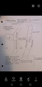
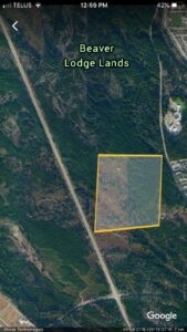
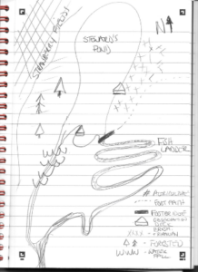
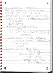
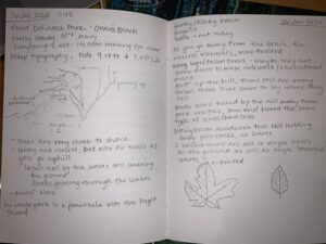
Study area – Beaver Lodge Forest Lands, Campbell River, BC.
Date – March 17, 2020
Time – 13:00 – 16:00
Altitude – 95m
Coordinates 49°58’20 N, 125°15’19 W.
Temperature – 10°C
Weather – sunny, clear skies, no wind
Size of area of interest– Harvested area 0.5km2, second growth forest 0.5km2
Total area of Beaver Lodge Forest Lands – 416 ha

Zone of interest: Transition between the second growth ecosystem and the relatively recent harvested area where no silviculture methods have been applied. Treeline of interest runs North to South. Area is a donated to the province for research in forestry, it is also used for recreation purposes and there is a network of mountain biking and dog walking trails.

Second Growth Ecosystem: Within the canopy of the second growth forest of Douglas Fir, Grand Fir, Red Alder, and Big Leaf Maple, there is evidence of old growth logging (large Western Red Cedar stumps logged by hand with spring board notches still visible). The trees have been planted and the vast majority are Douglas fir and Grand Fir of the same age, though there also seems to be some variation levels of the canopy with young trees growing.  In these areas of disturbance there is new growth of Red Alder and Big Leaf Maple, and in wetter areas it seems Western Red Cedar and Western Hemlock are abundant.

Main Ground Cover: Dominated by Salal, Red Huckleberry, Oregon Grape, Salmonberry, and Bracken Fern, with sparse Trailing Blackberry. The bottoms of the trees were covered in mosses and lichens and there were many areas where trees had blown down opening up the canopy for new growth. Salal and Oregon grape were very green with big broad leaves. Salal leaves were 4” long on average, and Oregon Grape leaves were 3” long on average.

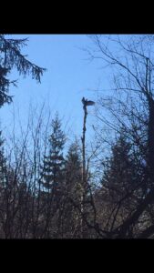
Animals: Not very much Black Tailed Deer sign. Bird life was abundant with American Robins, Varied Thrushes, and Stellar’s Jay flying about. Ravens were observed as well as Great Horned Owl calls (but no sightings this time).

Early Succession ecosystem:
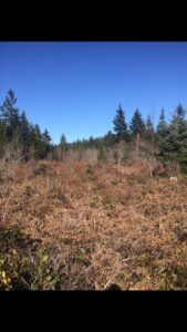
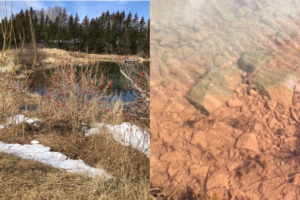
History: Harvested cutblock of unknown age. Stumps are a few years old and it is clear that it was not logged by hand and instead with a feller buncher. It either was hoe chucked or a skidder was used for yarding the logs as machine ruts have overgrown and become water filled depressions. Cleared area is 0.5km2 with a riparian zone cutting through the middle as well as a few small residual patches left standing.

Main ground cover: Bracken fern is dominant in open areas with intense sun along with abundant Red Huckleberry and sparse naturally regenerated Pine trees observed. There is a saturated riparian zone running through the block with slowly running water amongst blue-joint grass, Red Alder, Western Hemlock and Western Red cedar. The ground in this area is completely covered in blue joint grass and moss that seems to have out competed all competition. Salal and Oregon grape are stunted(<0.5m) with smaller leaves (<2”), many are red coloured, Oregon grape only found on the fringe of the forest.

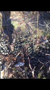
Animals: In the open areas of the cutblock there is a network of Black tailed deer trails with abundant scat and tracks. Some scat old and some more recent (black and shiny). Tracks were observed in the soft soil, measuring 2 ¾“ long, accompanied by much smaller ones which leads me to believe these were from a doe and fawn. In the wet riparian zone with tree cover there is abundant Roosevelt Elk trails and scat. I observed what looks to me like a possible Roosevelt Elk rut pit from last season. It is an area 10m in diameter that has been well trampled and 20+ groupings of scat. There was evidence of browsing on the new huckleberry shoots, though I expect it was from black tailed deer as there was more recent evidence of their presence in the immediate area (fresh track and scat). After following the elk trails and branching deer trails, I observed that all the trails heading out of the treed wet area were used by the black tailed deer, and all the trails heading through the safe wet cover and bluejoint grass were used by Elk. The deer seemed to be using the residual patches as safe cover for bedding zones and the open area as feeding zones, as there was evidence of beds in the covered area and a greater abundance of scat in the open area. The Elk did not seem to be venturing out of the safety of the riparian zone.

Main questions:
1) Is Western Red Cedar more abundant in wetter areas?
2) Do Salal and Oregon Grape need shade? They were both stunted in the sun, their leaves were small, and the increase of light intensity seems to have caused them to reflect different wavelengths of light, thus giving them red leaves.
3) Is an increase in blue joint grass correlated with an increase in Roosevelt Elk sign?
4) Are the species to first take advantage of openings in the forest different than those in the cutblock?
5) Have the trees in the harvested area been limited in their ability to recover due to competitive ground cover species?

Excerpt from field journal (pdf)

Blog Post 1: Observations


My chosen study location is next to the Cougar Creek Mountain Bike Jump Park in Canmore Alberta. There is a network of footpaths which connect the surrounding communities and in this particular spot there has been an abundance of water that has accumulated around one very large tree with no other growth for about a 4 meter radius around this tree. The main tree in this location is a White Spruce (picea glauca) tree and surrounding it is a cluster of Trembling Aspens (Populus tremuloides) as well as other White Spruce and Engelmann Spruce (P. Engelmannii) trees. There were Deer and Elk tracks present in addition to various dog paw prints but as this area is a common walking trail it is difficult to know whether the present paw prints were of domesticated dogs of from the resident wolf pack as they are also found frequenting the area.


As this region is at the bottom of the Bow Valley this would be considered part of the montane region of the Rocky Mountains. This region is known for diverse wildlife and plant species as the variation of meadows and forested areas provides plenty of cover for prey species in addition to many food sources for the community. This trail network suffers from over usage from the human population in the summer so the diversity and abundance of wildflowers in the summer months can greatly vary from year to year.


  1. Will the areas with evidence of the most human usage show the least species diversity for the local flora?
  2. To what extent will wildflower populations respond to good or poor water drainage as new growth begins to sprout as we approach spring?
  3. How does the elevation of the various tree populations relate to the growth and frequency of moss growth on tree trunks.

biobookblog1pageset1

biobookblog1pageset2


Blog Post 1: Observations

The area that I have chosen to study is Mount Tolmie in Saanich, British Columbia. It is a small mountain, about 120 meters in elevation. It has some residential buildings as well as a paved road and public viewpoint and picnic areas. This area is designated as a city park. This area is a diverse home to many plant species, most notably the garry oak and arbutus trees. I visited the area in mid-february, on a sunny morning with light clouds and wind. The mountain has lots of exposed rock and is fairly dry, and has some meadow. 

Some things that I would be interested in studying in this region could be along the gradient of elevation change. For instance, I could study the concentration of certain elements such as nitrogen, phosphorus and potassium in the soil. I could also study the species density of a certain tree or shrub in respect to elevation as well. I may also want to study the diversity of a specific division of plants, such as a moss. Species I could study are the garry oak tree, the arbutus tree, or the division bryophyta.

Feb. 14, 2020 field journal BIOL 3021

Blog Post 1 – Observations

Blog Post 1 – 14-01-20

The area that I have selected to observe is a partially wooded park nearby a community in Strathmore, Alberta. The area features several different types of trees and shrubbery, some of which include Aspen Poplars (Populus tremulodies) and Beaked Hazelnut (Corylus comuta). The area is a green park and surrounds a central pond. There are four different docks bordering the pond that serve as fishing sites in the park. There is also a small playground on the eastern side of the park as well as a water park to the south. There is a central walking path around the park that provides views of the aforementioned locations as well as wildlife and vegetation. The park is about 0.05 acres in width and about 1 acre long and it is found about 53.0km east outside of the city of Calgary in Alberta, Canada. The park is mainly flat with some small hills and is densely packed in areas with shrubs, bushes, and trees. Towards the interior it slopes down to the central pond which is bordered by Broadleaf Cattail (Typha latfolia). The area I have chosen to observe has the formal designation of Kinsmen Park. I visited the site on January 14th at 1100 hours. The weather was -29C in the winter season in Canada. There was a mild wind and skies were clear. There were some very small tracks in the snow, about 2 inches in length, potentially those of a hare and they led into the trees on the north-eastern side of the park. Potential subjects I am interested in studying for this project include the Mus musculus (mouse), Lepus americanus (snowshoe hare), and Pica hudsonia (black-billed magpie). Some questions I am looking to consider for my research project are the following:

  1. How quickly do certain tree types respond to warming temperatures and weather conditions in Calgary? In what ways do they respond to warming temperatures?
  1. Does magpie presence increase in forested areas near human communities as temperature increases?
  1. How do certain animal species function under conditions of freezing temperatures?

Blog Post #1: Observations

The area chosen for study is called Point Defiance Park in Tacoma, Washington, US. The park sits on a peninsula that is surrounded by the Puget Sound: Dalco Passage on the east and the Narrows on the west, and it is about 760 acres. Point Defiance Park is mostly forested with tall fir trees, besides the zoo and aquarium that sits on its lands. The perimeter along the Puget Sound is comprised of steep hills or bluffs down to the water.

I observed Point Defiance Park at 11:45 on the 26th of January, at which time the tide was at 9.10ft/2.77m and going down.  At that time there was approximately 20 yards from the water’s edge to the incline of the hill.  It was 50 degrees (F) and mostly cloudy, though it has been raining consistently in the area for almost one month, very typical for this season, but warmer than usual.

There seemed to be many logs that had accumulated, (but didn’t look like driftwood) between the beach and the sidewalk that has been paved alongside it. On the other side of the sidewalk, trees grow very close to the water: it seems that deciduous trees grow right along the shoreline, and just beyond that and as altitude increases, the presence of coniferous trees increases, as well as the density of the forest.  The park seems mostly un-interfered with: I found many fallen trees as I went through the forest, and the further I got from the sidewalk, the trails of prior park visitors faded. Some of the fallen trees had mushrooms growing on them as well. On the ground below the deciduous trees were leaves mostly of two types, corresponding to two types of trees along the shore. They had not decomposed yet, and grass has started to grow through the layer of leaves. There were ferns all over, but none yet showing new growth. I heard many birds with the same call, but did not get a good enough look to identify them, as well as many glaucous gulls. I did not see but heard other park patrons report seeing great blue herons further down the beach.

Three questions I have:

  1. Does the diversity of birds increase as you go further away from high-traffic areas of the park?
  2. Is the pattern of deciduous trees close to the water and coniferous further from the water consistent around the peninsula?
  3. At times of low tide is there a greater presence of gulls or other birds?


Field notes 1

Blog Post 1: Observation

Shannon Myles

January 30th, 2020


The study area chosen is a strip of grassland in Satellite Beach, Florida that separates the beach from the highway. The area covers a rectangle of about 250m alongside the beach and of about 90-100m deep towards the road. The land is flat from the road all to where the terrain abruptly drops 3-4 feet onto the beginning of the beach and eventually into the ocean.

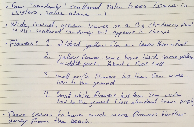
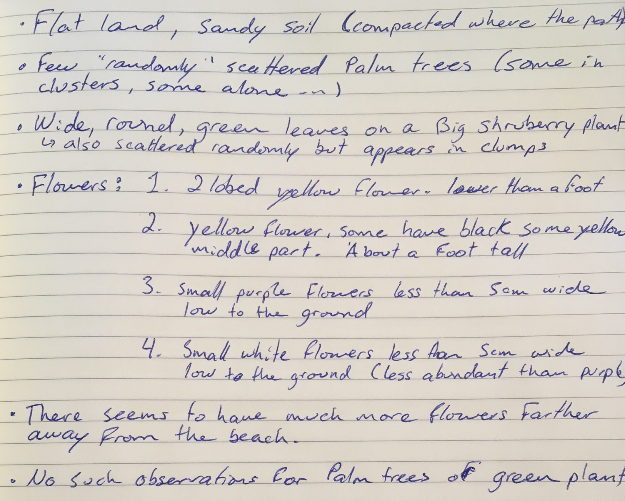
The vegetation in the area seems to be poorly diverse with only a few different grass types, flowering plants and palm trees. The palm trees are scattered in what seems to be a random pattern throughout the area. The site also has Sea Grapes, a type of shrub with large round green leaves. As for the flowering plants, four different varieties were observed in the field. Two yellow flower kinds, one very small white flower, and another small purple flower kind were seen at the site.

The area seems to have been left unshaped by man except for this one clear path of about a car’s width that goes from the road to the beach. The path is characterized by not having any vegetation other than short, scattered patches of grass. The soil seems to be very compact in the area, which leads me to believe that the path is used a lot or by heavy machines.

I visited the site around 12:30 on a sunny Wednesday. As the pictures show, a few clouds were in the sky. The temperature was 15C° and felt cold because of the wind coming from the ocean.

What interests me a lot about this site is the possibility to study the gradient formed by the step-cline created by the ocean meeting the land and its effect on the abundance or physiology of organisms. Some of the questions I had while walking through the area were the following:

  1. How does the abundance of flowering plants vary in relation to the distance with the ocean in the ecotone?
  2. Is the width of Sea Grape leaves affected by its proximity to the step-cline?
  3. Is there a correlation between the height of the palm trees in the area and their distance from the beach?

Field notes 1      Field site sketch

Post 1: Observations

The area that I chose is a portion of the Millstone River, located in the East Wellington area of Nanaimo, Vancouver Island. This portion of the river cuts through a part of Nanaimo’s designated farmland. Several small scale vegetable and feed crops are along this subdued portion of the river, as well as housing developments. The areas around the Millstone river is cleared of the forest canopy, but small forested buffer zones do exist along the course of the river. Historical mining existed within the area in the early 1900s, and mine workings exist below portions of the landscape. It is unknown if these factors influenced the river through its history, but contamination of well water in East Wellington is of concern.

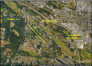
A proposal has gone through Nanaimo’s City Council to designate the area highlighted green in figure 1 as a Wetland Park.  Because of the reasonably shallow gradient of the landscape, the river tends to meander and create flooding within the park when the river is high, which attracts birds and other biota.

I visited the field site on January 26th at 2:30 PM. The landscape is almost clear of snow and we have received rainfall the past several days. Overall, Nanaimo has seen large amounts of precipitation this January, and the river levels are incredibly high.

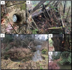
I accessed the river along the proposed park path and noticed that the large field in the park was partly flooded due to high river water. Walking down to the river, I saw that the river banks were nearly breaching, and large scale erosion was occurring along meanders (picture C). I could tell that at one point, agriculture had happened due to remnant barbed wire cutting through mature Douglas fir trees (picture D). Cow feed stalls in an advanced stage of decay were recognized, which could allude to the type of small scale farming that occurred. Invasive species that include English Holly, Himalayan Blackberry, and Scotch Broom are observed along the course of the river. Native species include numerous shrubs in hibernation, mature Douglas Firs, Maples, and alders. A possible beaver tunnel was the only signs of mammals at the site.

Some questions that I thought to myself as I was walking along the Millstone River included:

  1. How much has this landscape changed since humans began to influence it? 
  2. What positive effects will occur when the park expansion is completed, and could cyclical floods inhibit expansion?
  3. What does this unique niche bring to Nanaimo, and why is it worth protecting if the landscape is partly flooded for parts of the year?  

Blog Post 1: Observations

20-01-2020, 1300hrs-1600hrs.

Wakamow Valley, Moose Jaw, SK

Mid Winter, sunny day, -3degrees C

The area that I am going to study is Wakamow Valley in Moose Jaw, SK, my hometown. It is an urban park situated on Treaty 4 land, with 20kms of trails, and 500 acres of land (www.wakamow.ca). Within the valley runs the Moose Jaw River, at approximately 506m elevation (www.mapcarta.com/24501910). The area of Wakamow Valley that I will concentrate on includes Kingsway Park Ecological Reserve, Conor Park camping and recreation area, and Tatawaw Park (old Wild Animal Park) on the southern most edge of the park. There are four distinct ecological zones within just Kingsway Park: woodland, grassland, valley walls, and marsh. Conor Park and Tatawaw Park have been largely altered by tourism but both contain woodland, grassland and valley walls as well. At this time, it is mid-winter in the park, and I am finally able to do some research after a long haul of around -35 degrees C. There has been a mild amount of snowfall, and the park is easily accessible at this time.

Things I thought about on my hike through:

The road that cuts through the ecological zone and stream bed to access Tatawaw Park has been there for 80+ years. Some of the same marsh vegetation can be observed on both sides of the road but I wonder if there are distinct species that are present on only one side of the road now.

Do berries degrade differently naturally? Different colours of berry exist on the same branch but are both obviously rotten in the winter. Is this a normal differentiation or is it caused by disease/mold/etc.? Can it be observed everywhere in Wakamow or is it contained to the marsh area?

Does thorn length and distribution vary among berry bush populations based on location/sun/proximity to water/stream? Those closest to the river seemed to have significantly more thorns compared to those in marsh areas. Is it the exact same species or very similar but different species? Is it a product of age?

Distribution of berries: why is the marsh covered in berry bushes while stream-side it was hard to find any?

Distribution of mushrooms/fungus on trees: Majority of visible fungi found on trees east valley walls and marsh area while only two sightings on trees by stream bed. What affect does heat, shade, wind shelter have on distribution of fungi/mushrooms?


It is very difficult to find things to study in the dead of winter but will continue the search for something concrete to continue with.

Blog Post 1- Observations

I have selected  to make observations at the Don Edwards San Francisco Bay National Wildlife Refuge in San Jose, California. It is a 30,000-acre wildlife refuge that sits on the southern end of the San Francisco Bay, and is an oasis for millions of migratory birds and endangered species. About 37% of the refuge consists of salt marsh, brackish marsh and freshwater marsh. The rest of the refuge is mainly made up of ponds and mudflat, which houses plenty of shorebirds, fish and zooplankton. Specifically, I chose to make observations at one of the pond areas of  the refuge, which was made up of shallow, brackish (or maybe fresh) water and a muddy, grassy shore. I visited this sight at 4:15pm on January 16, 2020. When making observations, it was 12 degrees celsius and cloudy outside, with some sunshine peaking through the cloudy sky. Based on my observations, these are three questions that I find interesting.

  1. I observed a group of nearly 100 American Avocets standing and resting in a group, with each individual in very close proximity, in the shallow water of the pond. I wonder if they rest in close proximity to maintain their body temperatures, avoid predation or for another reason?
  2. I observed Black-necked Stilts and American Avocets (both are shorebirds) in the pond, near the shore. I wonder how different regions of the pond or perhaps, different ponds of the refuge with varying environmental characteristics (plants, buildings etc) effect shorebird species richness?
  3. I wonder if shorebirds (or one of these particular shorebird species) prefer to forage close to the shore or at increased depths, further out into the water.