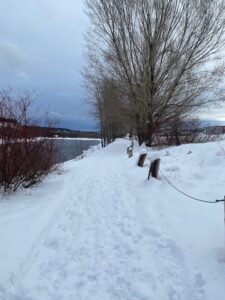
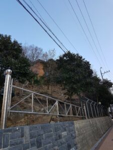
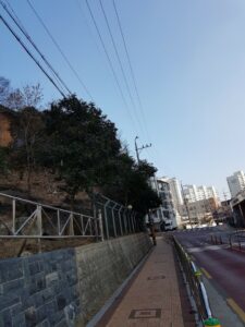
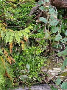
Size and Location: Cristopherson Steps in Surrey, BC. The natural areas alongside the stairs as well as the roughly 2 km stretch of beach front at it’s base.
General description: The stairs begin from a suburban street and go steeply down a ravine, eventually over a railway track and to a beach. It’s quite rocky in this area and the shoreline is eroding from both the sea on one side and the regular removal of plants from the track area behind.
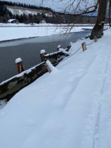
Designation: Cristopherson Steps is property of the City of Surrey but in the beach front area it is a mix of City of Surrey, BNSF Railway and potentially the provincial government because the tide comes very close to the area of interest.
Vegetation: Natural area alongside the stairs and down the ravine is mostly infested with ivy but there are also ferns, western red cedar, douglas firs. The beach front consists of deciduous shrubs and trees, and a mix of perennial and annual weeds.
3 intriguing questions:
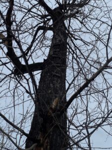
There are very young western red cedar trees no more than 6 feet in height that have germinated from seed presumably from the few larger specimens above (some are growing inside or along decaying tree stumps, therefore I don’t believe they have been planted). English ivy is already climbing these young trees and I wonder if western red cedar can survive without removing the ivy.
Along the beachfront the shoreline in front of the railway tracks is built up with large boulders. The areas that have Rosa and Holodiscus discolor growing within the cracks of boulders seem to be less eroded than the areas without. Do these plants stabilize the area better than the other more eroded areas?
The heavily eroded portions of the shoreline are sparsely populated with what I believe is Digitalis. I could not find it present in any other areas except where the shoreline has recently collapsed and the soil conditions seem poor. Are the areas where the shoreline has recently collapsed from erosion providing this plant with the conditions it needs to germinate and then not be out-competed by other plant species?
The study area I have chosen is Central Park on Denman Island, BC, Canada. Central Park is located in approximately the middle of the Island. Central Park is ~147 acres in size and contains two large wetlands and a recovering forest after years of logging in the area. It was logged by horses in 1998 and then heavily logged in the year 2000. The forest is specifically a Coastal Douglas-fir. This kind of forest is relatively rare in B.C. and is threatened. Local conservationists have identified up to 64 different birds that have been spotted in this park.
I visited this area first on June 24th, 2019 between 6:28 and 7:37 PM. On this day the weather was observed to have a low of 12 degrees C and a high of 19 degrees. It was sunny with clouds.
While on this walk I noticed 3 interesting potential study areas with the local ecology:
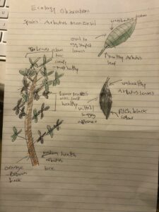
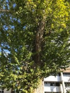
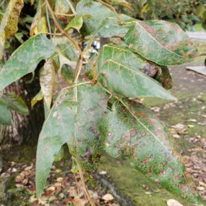
1.) Some but not all arbutus trees appeared to be dying or suffering from some ailment. Some trees had dark covered bark and leaves, while others had very little or no sign of damage. Arbutus are known to shed leafs and bark at various times in the year, but my observations were outside the normal leaf shedding. Why were some of these arbutus trees affected but not others, and why were some of them dying?
2.) In some areas ovate shaped leaves appeared covered in small holes. What organism or local weather or climate caused these holes in these particular areas?
3.) In some areas of the forest and meadows, there appeared to be large concentrations of thistle plants (dozens in a small parcel of land). Why were there so many thistle species in such a small area?
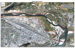
For my field observations, I have chosen Cottonwood Park in Prince George, BC. This is an interesting area, as it is a city park where the Fraser River and the Nechako River meet, but the majority of my study area only includes the Nechako river. This area is a river bottom, which is surrounded by industrial sites on the south side, and a very steep cut bank on the north side. My study area is in the SBSmh and is approximately 200 hectares in size, which includes the area of the adjacent rivers, but my observations will mainly occur on a 4.8km trail that I walk regularly (Figure 1).
Figure 1
However, I rarely walk the whole trail loop each time. As I do walk there often, I usually walk different sections at different times of the day and/or week.
To begin my observations, I walked the western portion of the trail on December 17, 2019, from 12:00-12:50pm. The sky was overcast, it was very windy, and was approximately 4 degrees. There was a big snowfall on the previous day, about 10-20cm, but it is already starting to melt due to the temperature. This park, as one could likely have guessed, contains many cottonwood trees. There are big veteran cottonwood stems all along the river bank, as well as many regenerating clones in the understorey.The understorey vegetation is surprisingly limited for a seemingly wet site. The only noted species were red-osier dogwood, black hawthorne, saskatoon berry, mountain ash, rose, as well as some different grasses. Parts of the river are frozen at this time, but only at the edges or in shallower areas. There isn’t much as far as animal signs, other than squirrel sightings today. However, as I do spend a lot of time here, I have seen chickadees, magpies, ospreys, hawks, eagles, hares, foxes, and bears during other visits. There are many signs of erosion here, as the trails have had to be moved in some spots, the retaining walls have begun to fall, and the concrete is cracked and broken throughout.
Some observations that I have made that may have potential for a research hypothesis are:
Does the fur color of hares change due to temperature or snowfall?
There appears to be only one fox that occupies the area, is this due to food, habitat size, predators, or industrialization in the area?
Do cottonwood trees that are closer to the river rot faster or slower than those closer to the road?
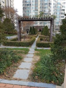
The area that I choose to observe is two area, that is close to home. Because I thought it would be more accessible and it would be easier for me visit anytime I want. I live in South Korea, Daegu. The location I choose first for the research is a park built in apartment complex I live in and the second is protected forestation area around nearby church. Although the apartment complex area is called a park, it is fairly small so it would be likely called as city street with ornamental trees and shrubs. The protected area nearby chuck is somewhat forested. I visited these area at December 14th, 2019 around 10:30 AM. The topography in apartment park is flat, while the protected area is small hill/ slope. The weather was sunny and temperature ranged around 8-9 degree celsius.
The idea I thought as I observed these area was mainly related to artificial intervention on nature, and can be pointed in majorly three points.
Were the various plant types in the park in the apartment complex only possible due to artificial intervention? So, can plants under artificial intervention go against the theory of natural selection? If so, in how much degree?
Compared to the park and other naturally formed plant landscape, a plant species thatis only at apartment complex park, Does this apply to artificial selection or invasive species?
The apartment complex park continues to maintain a much more visually beautiful appearance due to the care of the caretaker, compared with other naturally formed plant landscapes. Does this affect communication between different species each other?
All of the questions are derived from one big idea; Whether artificial intervention affect ecology or not. From this main idea I will derive more specific points as I go through the research.
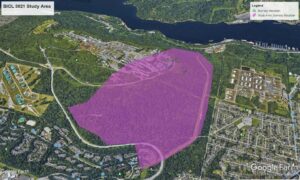
The area I have chosen is part of the Burnaby Mountain Conservation Area shown below.
Study Area
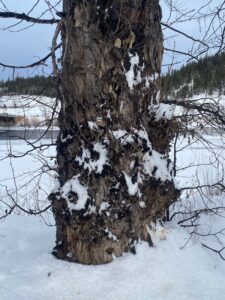
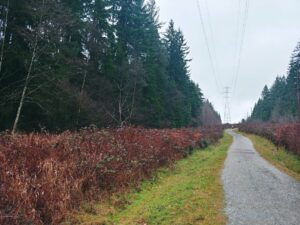
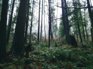
The area is 1.85 km2. The part of the mountain I have chosen rises from roughly 160m to 290m above sea level. The majority of the area I have chosen is covered in forest with hiking trails and a high voltage power line going through. I have visited my site twice once on November 24th at 3:30pm. The temperature was around 7 C and the ground was wet. The second time was on December 8th from 1:00pm-3:00pm. The temperature was around 10 C and the ground was wet. The animals that live on the mountain include deer, squirrels, coyotes, raccoons, mice, rats, steller’s jay, and humming birds. There are many varieties of plants including ferns, maple trees, dogwood, Douglas fir, western hemlock, an
Power line Trail
Forest Area
Red cedar. There are an innumerable amount of fungi. I have included several photos of the trail showing the power line surrounded by grasses and small shrubs in Figure 2, a mountain train in Figure 3 surrounded by forest and ferns.
The area is popular for dog walkers and mountain bikers. As such seeing any animals besides squirrels is uncommon as they shy away from humans. From my walks I had the following questions:
Fungi are abundant in the forest why there are not any along the power line trail?
What trees are indigenous to the area and which have been brought in?
What parts of the study area have been logged if not the whole area in the past 100 years?
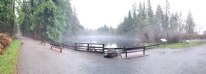
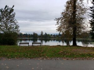
As I arrived at the Lake it was shrouded in mist, obscuring my view on the north side. As I continued to observe the plant life at the lake, the mist started to lift and that is when I noticed the hooded mergansers. The male was showcasing his display for the female. The female would start to come closer to the male then retreat. This was repeated many times, only interrupted by their diving underwater.Lost Lake is found on the eastern side of Mundy Park in Coquitlam, BC. It is a small lake in a dedicated forested (City park) surrounded by urbanization of residential housing and schools on all sides. Lost Lake is the smaller of the two lakes in Mundy Park, the larger being Mundy Lake. Lost Lake is special in that it is known to house a species-at-risk, Western Painted Turtle – Coastal Population and to provide possible habitat to other species-at-risk such as the red-legged frog and the pacific water shrew. It is a permanent body of water, that is usually still with an outflow on the southeast corner into Lost Creek that flows in a general southerly direction toward the Fraser River.
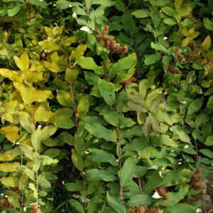
The vegetation surrounding the lake is mainly conifers with some deciduous shrubbery closer to Lost Creek. The majority of shrubs were devoid of leaves but some had leaves turning colour. The red elderberry had bright yellowed leaves, of the leaves still remaining on the shrub.
Lost Lake is inaccessible to park users on all sides except on the south side, where I stood, there is a viewing area with benches. There is also a trail that goes near the lake on the west side, that runs north – south, but it does not allow access to the lake. I observed many park users walking their dogs off-leash here and some of the dog owners were throwing balls off-trail for their dogs to go and find in the forest.
The lake is about 170 metres long running north to south and about 50 metres wide from east to west. I’ve been to this lake many times throughout the different seasons but this is the first time I’ve seen hooded mergansers using the lake.
Why are hooded mergansers on the lake at this time of year when I have not observed them at any other time of year on the lake before?
Is there noticeable degradation of the forested area by park users between Lost Lake and the nearby trails systems?
Inventory – what is the species diversity of Lost Lake in Winter?
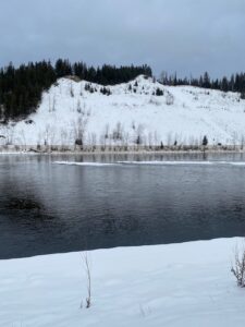
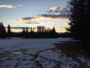
Just north west of Fort St John, BC, lies Charlie Lake. From the southern tip of this lake runs Fish Creek. Fish creek is a small creek that runs approximately 14 km, flowing first south east and then turning northeast to flow in to the Beatton River. I have chosen to observe a roughly 2.5 km section of the creek about 3/4 of the way along it’s path towards the Beatton River (Google Maps, 2019). The above measurements are very rough estimates.
In the area I have chosen for study, Fish Creek snakes its way through a rather steep gully. I visited the area on 19-11-17 at approximately 1510 until 1630. It was unusually warm for November at 9 degrees Celsius. It was quite windy (I guessed it was 30 km/hr gusting 50 km/hr out of the south west) but sunny. I will try to remember to bring my Kestrel next time to get a more accurate weather reading.
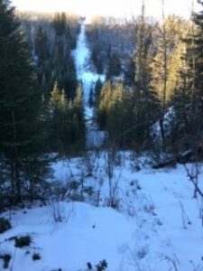
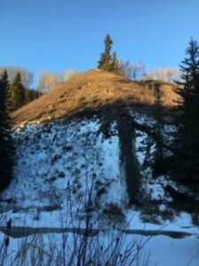
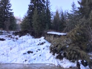
On the south facing bank of the gully itself the flora is predominantly grassy with some smaller shrubs, most likely Prickly Rose (Rosa acicularis). At the top of the slope on that south facing side there stands mostly Trembling Aspen (Populus tremuloides). Behind that lies farmed crop fields (these fields will not be included in my study as they are private land). At the bottom of both sides of the gully, directly adjacent to the creek, there are flat, sort of swampy areas with Prickly Rose and what I am pretty sure is Blue Wildrye (Emlymus glaucus), though it is hard to tell at this time of year, and a “willow” shrub that I do not know the name of, though it has been on my list of plants to learn for a while now. What I do know is that moose love it as a forage. I have observed in many other locations the tops of this shrub neatly snipped off by the big mammals. The north facing slope is predominantly a stand of mature White Spruce (Picea glauca) with the odd Paper Birch (Betula papyrifera) and Trembling Aspen. The under story is mostly Blue Wildrye and Prickly Rose (making it somewhat unpleasant to walk through). There are pockets of Trembling Aspen stands on mid slope benches. At the top of the north facing slope there is a band of mixed trees, though most are Trembling Aspen. Behind this there lies a golf course. I will be including this grassy course in my study area as I access the Fish Creek gully (which is Crown Land) via the public path through the golf course. I access the lower part of the gully via a pipeline right of way that runs straight down the north facing bank and then up the south facing bank on the far side. The right of way is open grass with some White Spruce regeneration.
Pipeline Right of WayGolf Course (looking west)
One observation I noted was the difference in apparent slope instability between the north facing and south facing slopes. There is fairly abundant evidence of slides and slope instability on the south facing slope at all levels. On the north facing slope, there is considerably less, though still some evidence down low. Perhaps this has to do with the north facing slope having a gentler pitch and mid level benches? Perhaps the presence of White Spruce provides better stability? Maybe because snow melts faster due to sun exposure on south facing slopes (Williams, 2018) the slope becomes saturated and is more prone to slide? I would be very curious to look in to the relation between the south facing slope and its apparent instability.
South facing slope (instability present)Northern bank instability along creek
I saw one Common Raven (Corvus corax), but no other live animals. I have seen many Red Squirrels (Tamiasciurushudsonicus) in the general area and was therefore surprised to not see any on this visit. I find these little squirrels very endearing and will be keeping an eye open down there for them. What do they do in the winter in this area? Do they prefer the White Spruce to the Trembling Aspen? Do they prefer the slopes or the flat lands? I imagine that they go in to hibernation for the winter months, but I do not actually know that for a fact.
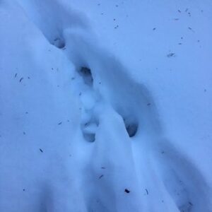
In the grass land up top, I observed (and have many times in the past while in the area walking my dogs) heavy traffic by Mule Deer (Odocoileus hemionus), as evidenced by their hoof prints in the snow. I was expecting to follow their trail all the way down the pipeline right of way to the bottom of the gully and then along the creeks edge. They did not appear to go all the way down though, and I am not sure at which point they veered from the right of way. This is a question that I am very interested in researching. What are the winter traffic patterns of Mule Deer in the area? Where do they bed down? Where do they feed? Do they prefer the open south facing slopes to the flat golf course? How does snow pack affect their behavior? I chose my area of study knowing that Mule Deer frequent the area and will likely base my research on their patterns in this area, where man-made field meets forest and gully.
Mule Deer tracks
I also noticed several Canine tracks in the snow on the pipeline and down at the bottom of the gully. There were many sets of tracks, traveling along the creek’s edge and crisscrossing it. There appeared to be different size of tracks. Perhaps Red Fox (Vulpes vulpes) or Coyote (Canis latrans)? I am confident they are not some one’s dog as the area in the gully has no paths or human traffic (aside from me) evident. I am interested to understand more about these canine’s travel patterns though the area. It would be interesting to find out if they prefer to run over the frozen creek (when it does freeze), or on the flats beside the creek. Does snow depth or slope have an effect? Does the presence of these canine’s affect the Mule Deer in the area?
I have started these observations at a good time of year as the season is shifting from fall to winter. I will be using this seasonal change to help me focus my study.
Sources:
Google Maps. (2019). Retrieved November 20, 2019, from https://www.google.com/maps/@56.278364,-120.8526553,7633m/data=!3m1!1e3
Williams, D. (2018). Differences Between North- and South-Facing Slopes. Retrieved November 20, 2019 from https://sciencing.com/differences-between-north-southfacing-slopes-8568075.html
Biology 3021
Community and Ecosystem Ecology
Blogs by E. Carmen Bell
Blog Post 1: Observations
Already, this Ecological Field Study has taught me many things. It has taken me weeks to settle
on potential field study locations and considerations. I believe this has to do with my perspective being
originally too narrow for the assignment. I was searching for a particularly interesting angle from
which I could make a detailed study and inventory and may have been attempting a prescibed outcome.
However, I now understand that my scope needed to open to a wider lens. Time spent in two situations,
as well as, revisiting the Biology 3021 requirements, guided me to observe the patterns of interacting
species of flora and fauna.
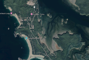
Comparing two potential field plot locations, situated across the Esowista Peninsula from each
other, may provide an interesting exploration into the similarities and differences between coastal
shorelines on the inside and the outside of the peninsula. The inlet plot location is slightly NE from the
Ecolodge on the satellite image below. The outside coastal plot is towards the bottom of the image,
along Chesterman Beach and before the spit that looks like the tail of a ‘Y’.
Credit to Google Maps
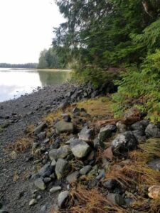
Salt water tidal fluctuations make contact with the inlet plot location at high tides when close in time to
the new and full moons. Both sites are close to high tide levels, the Eastern site is less than 5 meters and the Western site is approximately 20 meters to high tide water lines at this time of year. Both sites surely receive wave action during storm surges. During today’s observations, it was a flooding tide, less full by one to two hours.
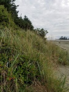
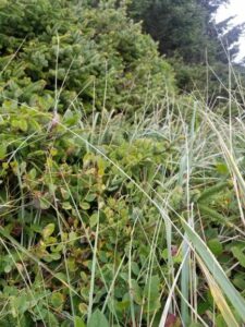
Picea sitchensis, Thuja plicata and Tsuga heterophylla trees were interwoven with Gaultheria shallon
and Vaccinium parvifolium, whom still had the odd berry dangling. There were Blechnum spicant and
Polystichum munitum ferns and grasses of which I have yet to identify. I observed patterns of layered
growth on nurse logs and transitioning ecotones over depths of 5 meters from where the forest becomes
the beach. While on location at the sites, I have observed an eagle, osprey, heron, robin, blue jay and
today, a delightful small bird with a yellow patch that I must identify. Different times of day may
provide for different observations of bird life.
East side of Esowista Peninsula West side of Esowista Peninsula
My visits to these locations have been at high tide and low tide, morning and late afternoon.
They are each approximately ten meters wide and 5 meters deep from the shoreline into the forest. The
gradients have a similar topographical slope upwards into the bush. Today, 3-10-2019, I was at the inlet
location at 1500 hours and the sandy beach location on the outside of the penninsula at 1700 hours.
There was a light wind of about 10 km/hr, the temperature was 13 degrees Celsius, there were cumulus
clouds in a patchy sky that gave pockets of gentle sunshine. No fog was visible at these times. The inlet
plot is roughly 5km South of the Tofino community within the property of the Tofino Botanical
Gardens. The western beach plot is about 3km Southwest of the inlet plot, “as the crow flies”, is of
District of Tofino designation closest to the ocean and private land on the forested aspect. The
coordinates of Tofino, British Columbia, are 49°08’N 125°54’W. The Esowista Penninsula lies on the
western side of Vancouver Island and is not sheltered from the open ocean by large land masses.
Flora of the western (beach) site. Flora of eastern (inlet) site.
As I develop my field journal, it will be valuable to sketch the layers of plant
life as I am expecting to see new members of the population with each visit. I question whether there
are differences among plants of the same biological species in the different locations? Being that the
temperatures have been above twelve degrees on my previous visits, I question whether there will be
observable changes in the flora and any animal species interacting with these communities? I question
whether the ecotone transitional vegetation, as well as yet to be discovered small creatures, will be
different over the 5 meter depth that spans forest to beach contrasting the two locations? I look forward
to exploring what these organisms are doing in their environments and discovering the patterns of
interactions exhibited.
Carmen Bell, 03-10-19
Chesterman Beach, Tofino, British Columbia, Canada.
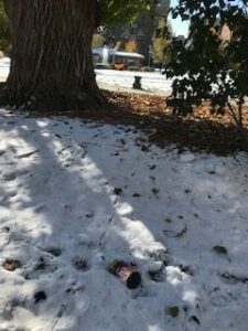
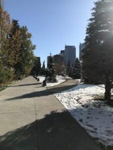
The area that I have selected to study is the oldest city park located in the heart of downtown Calgary, AB. I’ve chosen this area because it is easily accessible and I can visit when needed. It is often frequented by humans and animals (ie. dog, squirrels, and birds) alike.
The approximate size of the park is 100m x 170m (the average block size in Calgary), and is about 2 hectares (according to The City of Calgary). The park is flat with ornamental trees, shrubs, and seasonally planted flowers (all of which have been taken out now). It also has pathways, both concrete and rock, and houses a few monuments, two fountains and a library.
I visited the park Oct 9, 2019 at 4:00pm. The weather was sunny and cloudless with a slight breeze, and at a temperature of 3°C and humidity of 48%.
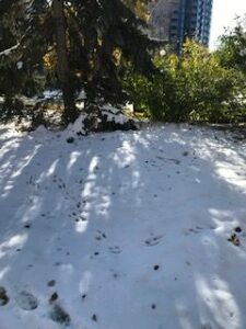
Throughout the spring and summer, the park had flourished more then other years. This summer, in particular, had much more rain compared to others and the humidity was, and still is, significantly higher as well. It has also begun a snow a couple time, earlier than when it usually snows in Calgary. Now during Autumn, after the second snow, the park is still green in some areas and quite decayed in others, in specific, the deciduous trees. There also seems to be the same amount of sunlight throughout the park, visible from the amount of snow that is left is similar in all areas. Lastly, I noticed that only two types of birds visit or stay in the park: Magpies and Crow. They would normally perch in particular tree, but will jump and walk along the grass and pathway below doing, what seems like looking for food. Squirrels are one of the only rodents in the park and behave in a similar fashion to the bird.
From my observations, these are the questions that came about:
As the park is well maintained by the city, how will the trees change along with the season? And how will that affect the birds and mammals that live there?
How does the humidity level, potentially due to increase rain and snow, affect the trees and greenery? It would also be interesting to see, due to snowfall and sunlight, how and if there will be changes in flora in the park?
Where the birds (Magpies and Crows) and squirrels particular to certain trees in the park because of habitats made in those trees, and/or if there is a food source nearby, and what that source is?
The location I have chosen to observe is a small segment of Mill Lake Park in Abbotsford, BC. I chose to situate myself on the North side of the lake, at the fourth bench from the parking lot. The co-ordinates were N49°2’44.36117″; W122°18’51.40163″. The altitude of my area is approximately 33.4m.
The area is approximately 80 ft by 50 ft. It is comprised of a paved walking path, a grassy field area, a picnic table and bench area, a 2 ft retaining wall, and opens on to the man-made lake front.
Mill Lake, Abbotsford, BC
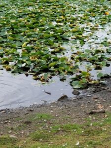
My first visit to the park occurred on Tuesday September 10, 2019 from 17:30-17:45. The weather was partially cloudy. Sunset was anticipated at 19:33 that evening. No rain was measured. The temperature was 20.1°C; humidity was 48.1%; pressure was 756.99 mmHg; and light was 3173 lux. During the 15 minute period that I was recording, I observed 53 people, 2 domesticated dogs, 3 bees, 32 ducks, and 33 Canadian geese. The ducks and geese were located in the water or on the shoreline before the 2 ft retaining wall. The people and dogs stayed predominantly on the paved walking path. The bees kept trying to land on my shirt but otherwise stayed air bound while I could observe them. The geese were the most vocal of all the animals observed. One would begin honking and then a group of 10 or more would take to the air, all honking and fly toward another group of geese who would respond in kind by taking to the air, honking, and then both groups would settle in new positions on the lake. The interaction appeared neither aggressive nor friendly.
I also observed several plant species though have been so far unable to identify any definitively. I believe that they include poplar trees, British Columbia fir trees, waterlily, and a bush that I was informed was called “Butterfly bush” – though a quick google search indicated that this could be any number of species.
I left the lake with several questions. 1) Why are the geese honking at each other? Is this play, territoriality, general communication of a threat, or aggression? 2) What are all of the plants in this area? 3) Will the populations of different species observed vary in correlation with the temperature or weather conditions?
This final question is where I believe I will focus my energies in this field study.