Post 1: Observations

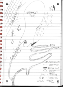
I have chosen Bronte Marsh as a study area. The marsh is a remnant coastal wetland area at the downstream limit of Bronte Creek before it flows into Lake Ontario. It is surrounded by urban development within the Town of Oakville, Ontario. Despite the urban development around the marsh, the Bronte Creek watershed is mostly undeveloped, with only 4% settled between urban and rural settlements (Conservation Halton, 2002). The marsh is bisected by Bronte Creek, with a total area of approximately 2.64 hectares on the south side of the creek and 1.63 hectares on the north side of the creek. The open water in the south marsh is approximately 0.53 hectares. The marsh is contained within a natural valley corridor/ravine with steep slopes that are predominately shale, with an exposed shale outcrop at the north limit of the valley slope, immediately upstream of the marsh.


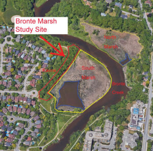
For the purpose of this study, I have chosen to focus on the south marsh and the adjacent valley slope due to accessibility of this area. I frequently walk the south marsh area as it is close to home and it’s bordered by Riverview Park with a walking path adjacent to the marsh. The path traverses the top of the slope on the southwest side of the marsh, and adjacent to the open water area on the southeast side of the marsh. The north marsh is mostly inaccessible as it borders private property.

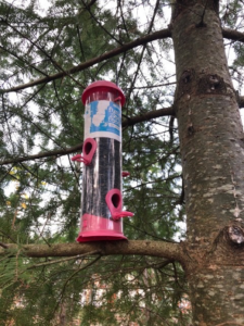
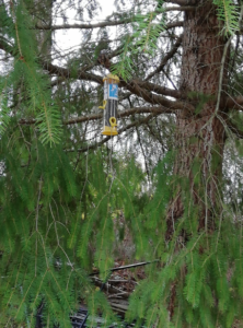
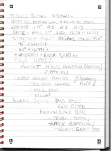
I conducted my initial site visit on April 30, 2020. I have provided observations below summarized from my digital notes from my mobile device. I have included my digital field notes and some photographs following these observations.

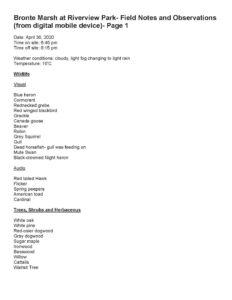
Date: April 30, 2020

Time on site: 18:45

Time off site: 20:15

Temperature / Weather: 10°C / Cloudy, light fog, changing to light rain

Observations

Wildlife- Visual

  • Blue Heron
  • Double-crested Cormorant
  • Mute Swan- nesting
  • Red-winged Blackbird
  • Common Grackle
  • Canada Goose
  • Beaver
  • American Robin
  • Grey Squirrel
  • Gull species
  • Horsefish- dead
  • Black-crowned Night-Heron
  • Red-necked Grebe- nesting

Wildlife- Audio

  • Red-tailed Hawk Flicker
  • Spring Peepers
  • American Toad
  • Northern Cardinal

Trees, Shrubs and Herbaceous

  • White Oak
  • White Pine
  • Red-osier Dogwood
  • Gray Dogwood
  • Sugar Maple
  • Ironwood
  • Basswood
  • Willow species
  • Black Walnut
  • Cattails

Invasive Species

  • Common Buckthorn
  • Vine species

Notes

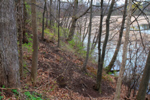
  • Study area from south limit of ravine in Riverview Park to exposed shale valley wall adjacent to and including the marsh on the southwest side of Bronte Creek
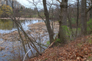
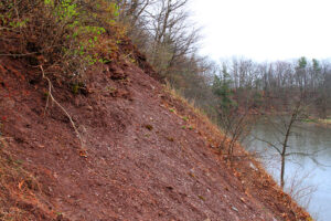
  • The soil on the slopes was red shale with minimal ground cover
  • Large trees along full length of the ravine slope- mainly deciduous with mix of coniferous, many with tree cavities observed
  • Exposed shale valley wall with no vegetation at upstream limit of study site
  • Storm sewer outlet near north limit of study area
  • The most dominate understory was common buckthorn
  • Granular pathway west of the ravine varying in distance from 4 to 10 m from the top of the ravine slope
  • The marsh area was dominated by cattails with no Phragmites observed
  • The dominant wildlife observed in the marsh included red-winged blackbird and common grackle
  • A staff gauge was observed at the Marsh inlet/outlet with a depth noted as 0.58 m.
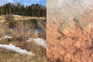
  • The water in the marsh and the creek was clear


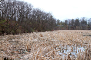
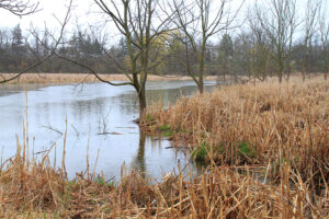
As noted in the field notes, the marsh is dominated by cattails (Typha spp.) in the wetted areas with a surface area almost four times the surface area of open water. There was abundant wildlife observed with red-winged blackbirds being the dominant species. The water was clear with no offensive odour.

The upland area is a steep valley slope with a mainly deciduous canopy cover of white oak (Quercus alba), maple species (Acer spp.), and eastern white pine (Pinus strobus). The understory consists of native species such as gray dogwood (Cornus racemosa), red-osier dogwood (Cornus sericea), and invasive species including common buckthorn (Rhamnus cathartica) and climbing vine species (unidentified). The ground cover is very limited with minimal grasses and herbaceous species identified as part of this initial site visit.

Three questions that I find interesting from my observations include:

  1. How is the dominant understory of common buckthorn impacting the establishment of native understory/woodland species? What are the effects on the biodiversity of the ravine ecosystem as a result?
  2. How has the marsh maintained minimal to no impact by invasive Phragmites and what are ways in which it can be prevented from being impacted in the future?
  3. With the recent rise in Lake Ontario water levels, how does this affect the marsh ecosystem? More specifically, how might it impact the viability of breeding marsh birds or what sort of effects does it have on the aquatic vegetation?

References

Conservation Halton. 2002. Bronte Creek Watershed Study. Retrieved from: https://conservationhalton.ca/uploads/bronte_creek_watershed_study_-_a_-_final_-_2002.pdf

Blog Post 2: Sources of Scientific Information

Impact of modified tillage on runoff and nutrient loads from potato fields in

Prince Edward Island

R.J. Gordona, A.C. VanderZaaga,d,∗, P.A. Dekkera, R. De Haanb, A. Madanic

This is a peer-reviewed, academic research paper.

All the authors are affiliated with a university/school or a research facility:

  • School of Environmental Sciences, University of Guelph, 50 Stone Rd. East, Guelph, Ontario N1G2W1, Canada
  • Prince Edward Island Department of Agriculture, Forestry and Fisheries, Charlottetown, Prince Edward Island, Canada
  • Nova Scotia Agricultural College, Truro, Nova Scotia, Canada
  • Agriculture and Agri-Food Canada, Ottawa, Ontario, Canada

The paper contains methods, results, and a conclusion.

It includes in-text citations and a bibliography

It is peer-reviewed-As Science Direct is a peer-reviewed publication. From their website:

ScienceDirect is Elsevier’s platform of peer-reviewed scholarly literature.

The article does acknowledge:

Acknowledgements

This research was funded by the Canada/PEI Water Supply Expansion Program. The funding agency had no involvement in the study design, analysis, interpretation, writing, or publication.


Blog Post-2

Cloyed,C.S., & Eason, P.K., (2017). Niche partitioning and the role of intraspecific niche variation in  structuring a guild of generalist anurans. Royal society open science.,https://doi.org/10.1098/rsos.170060


The paper I choose  “Niche partitioning and the role of intraspecific niche variation in structuring a guild of generalist anurans” by Cloyed, C.S., & Eason, P.K. This is an academic, peer-reviewed research article published in the Royal society open science. It has a materials and methods, results, conclusion, acknowledgments and literature cited section.The article includes footnotes and citations all cited at the end, and was reviewed by Bryan Hayden and one anonymous reviewer. This paper gives me more depth about studying niche partitioning among birds though this paper examined niche partitioning within a group of five anurans and determined whether variation within species could facilitate resource partitioning.  As their study concludes that these species partition their niches by feeding at different trophic levels and foraging at different distances from ponds.

Blog post-1

The study area chosen for the field study is backyard of my house and backyard of my friend’s house, in Courtenay, Vancouver Island, BC. Both the backyards are around 4.7km away . Both the areas are rich in bare ground, small gardens.  At both the backyards there is one big tree which is used to hang my feeders on. Both the areas are same in terms f vegetation. It is a residential area with flats and buildings. I initiated this research project to identify the key ecological features of most abundant local birds’ species in this area and to study their feeding habits and recording their behavior. I started observing the birds in both the areas  in starting of April month (15-17 C temperature), during the noon time when there was adequate sunlight in order to the abundance of different bird species. As I am focusing on studying the different habitat partitioning among birds or niche partitioning (the word niche basically means the role and the position a species has in its environment) which they undergo to reduce competition, another question can arise on seed preferences by providing 8 different types of seeds and record the most preferred ones or some birds eat at different times of day to reduce competition. These all are questions that came across during the study.

Post 9 – Relfection

I found this project to be very difficult.  I think the most difficult part was coming up with a subject to study and a hypothesis.  I made several changes to my research, and actually completely changed my location, hypothesis, sampling method, and pretty much everything after my first attempt at data collection.  Furthermore, it may have been beneficial to go and collect more data, but due to CoVid, the park is now closed.

This research did teach me more about how ecology theory is developed, but I think I actually found the assignments in which I needed to assess others people studies more helpful.  My study itself was too limited, and eventually just got to the point of needing to be finished and out of my life. Regardless, though not necessarily my best work, it was a new experience that will further help me develop my education are career.

Post 1: Observations

Post 1: Observations

The area chosen for this project is a managed nature park approximately 75 m2  that is part of a larger 4,460 ha watershed. Located in Queens County, Prince Edward Island, this is an area of mixed Acadian forest, riparian and agriculture land. There is a small freshwater pond that feeds the Westmoreland River, that eventually leads to the Northumberland Strait. There is a man-made fish ladder and artificial waterfall to help migratory fish species. The elevation is at sea level, with rising elevation of 10 meters to the northeast. The first site visit was April 8th, 2020, on a clear day, with no precipitation, slight wind, and a temperature of 4°C. The area had been completely covered in snow up until 3-5 days prior, with some snow still present.

Live animal sightings and sign included:

  • American Black Duck (Anas rubripes)
  • American Bald Eagle (Haliaeetus leucocephalus)
  • Belted Kingfisher (Megaceryle alcyon)
  • Water Boatman (Garridae, spp)
  • Various passerines
  • Frog sounds-unidentified
  • Unidentified Aquatic Eggs-most likely macroinvertebrate…TBD
  • Signs of mice or vole over-wintering.


Some thoughts on research projects include:

  1. Water quality testing to determine the effect of agriculture on the local ecosystem, particularly amphibians.
  2. Amphibian inventory to determine how their health correlates with the health of the ecosystem
  3. Amphibian inventory to assess which habitat is being used the most and how to best improve that habitat and discourage human interference.

I do know that I want my research to include amphibians, as there is a gap in information on Prince Edward Island about local amphibians, their numbers, and their health. I plan on using a vlog to take temperature readings, but I am not sure how I will use that data. I am hoping to find egg masses that belong to frogs or salamanders, and possibly put the vlog there-maybe I can draw a correlation between water temperature and hatchings.

Figure 1: View from the south facing northwest

Figure 2: Egg masses-ID TBD


Post 8

I created a few graphs, but in general they show how many conifer seedlings were browsed, or not browsed with the presence or absence of red-osier dogwood.  My data was simple, so making graphs was not difficult.  However, I have yet to decide which table and graphs I have made will go into my actual report.  The results did mostly show that conifers were less browsed when red-osier dogwood was present, however, this varied with tree species.  This had led to question of is there is diet selection of conifer species as well as diet selection of shrub vs. conifers for ungulates.  It would appear that they prefer subalpine fir, however, much of literature I have read suggests that ungulates prefer Douglas-fir.

Post 7

The theoretical basis of project is around ungulate winter diet selection of regenerating conifers.  This requires looking at topics around ungulate habitat needs, food selection, land use of ungulates, browse pressure on vegetation, and land manager treatments to avoid browse pressure on confer seedlings.

Key words: Ungulate food selection, ungulate browse pressure, conifer seedling damage

Post 6

Since my last posts, my project has changed substantially.  I am now observing if the presence of red-osier dogwood within 1 meter of conifer tree decreases its chances of being browsed by ungulates.

This was completed at LC Gunn park in Prince George.  I created seven 30 meter transect lines, of which I counted every regenerating conifer stem within 1m on either side of the transect.  I then recorded the height of the tree, if it was browsed by an ungulate, and if red-osier dogwood was present within a 1 meter radius of the tree.

I actually did notice that less regenerating conifers were browsed if red-osier dogwood was present.  However, I am still unsure as to why this is.

Data collection went smoothly, and I did not see any reason to change my methods.  In total, I counted 68 trees, with the majority being subalpine fir, then Douglas-fir, and hybrid spruce, respectively. Of those, 30 had red-osier dogwood present within 1 meter, while 38 did not.

Post 5 – Design Reflections

My initial data collection was not difficult.  The plot locations were easy to get to other than the 20cm of snow that was unpleasant, but otherwise the terrain is very accessible.  The data collected showed that there were actually very few regenerating cottonwood stems, which at first glance, I thought there would be substantially more.  There were also less coniferous species found than expected, but this could also be due to the fact that small stems are under the snow, or have been browsed.  The amount of woody shrub cover can make plots difficult, as there are a lot of plants to maneuver around.   The only modification I may make is increasing plot size from a 3.99 meter radius (50 meters squared) to a 5.64 meter radius (100 meters squared).  This could improve the accuracy of the estimated density of tree species, as a larger plot may pick up more species, improving the estimated density.  It may also be helpful to actually count the number of shrub species in the plot as opposed to estimating their percent (%) cover, as these plants could be the main reason as to why there are very few coniferous species establishing in the area.