Blog Post 9: Whispering Woods Reflections

Reflecting on my field research, I have come to appreciate the importance of preparing before starting to implement research. Throughout my data collection I had to modify my predictions, hypotheses, and sampling methods multiple times. This is because the more knowledge I gained from my peers, professor, and supporting literature, the more I recognized ways of better carrying out my research project. Given the time limits in which I had to carry out the data collection, this was partly inevitable. However, for future research I will make sure I spend more time collecting as much background information as I can before implementing my data collection.

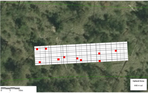
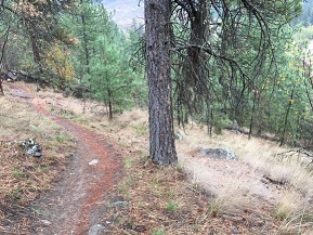
Still, by the end of my field experiment, I ended up where I initially wanted to be. For instance, while my original focus was on soil moisture and soil pH, I am now have the knowledge to know that my focus was actually dealing with autumn senescence differences. My study design and implementation was not altered much. Small changes were made to better encompass replication, randomization, and measurement accuracy, but the actual implementation went quite smoothly. The largest issues I faced were not knowing how to put my thoughts and purpose into words until I spent more time looking at supporting literature.

This research project has undoubtedly increased my appreciation for how ecological theory is developed. Through reading existing literature and carrying out an experiment myself, I have come to appreciate the value in what seems like insignificant findings. Without the existence of ecological data and results, regardless of how small, it would be impossible for researchers to draw conclusions and, eventually, create theories. I have also come to appreciate the intricate and difficult process of developing ecological theories. For my research topic specifically, there is vast research looking into what controls autumn senescence in trees. Many authors have produced similar findings and conclusions, but many have also contradicted each other. The one similarity among all of the literature I reviewed was that all have acknowledged the inability to form an theory on how autumn senescence is controlled. My research is no different. It has not solved this underlying problem. Still, my field research is one more piece of data in the ever-accumulating pool of data that will eventually help produce a theory.

Overall I really enjoyed the process of creating and carrying out field research. I enjoyed researching how my findings fit into the broader scope of existing literature, and how they are important from a big picture point of view.

That’s all!
Madeleine

Blog Post 8: Tables and Graphs

The graph I submitted for my Small Assignment 5 illustrates the relationship between slope incline (%) and common snowberry density (stems/m2). I added a linear trend line to my line graph to visually show that as slope incline (%) increases, the density (stems/m2) of common snowberry decreases. To produce this graph, I stratified my slope incline (%) into four distinct ranges. The ranges were 0-5%, 6-10%, 11-15% and 15%+. I determined these ranges based on my data collection. I then manipulated my data by changing the number of stems per quadrat I collected into density (stems/m2) by dividing my stems per quadrat by 2.25m2. I then calculated the average density in each slope incline (%) range, for example between 0-5% slope incline, the average density of snowberry was 15 stems/m2. Between 6-10% slope incline, the average density of snowberry was 8 stem/m2.

The linear trend line on my graph illustrates the general trend I was predicting in support of my hypothesis, that snowberry distribution is determined by slope incline (%). Specifically, I predicted that snowberry will be present in area where slope is less than 20% and that snowberry density will decrease as slope incline (%) increases.

When I was first organising my data and producing graphs, I didn’t think my results were showing the trend I predicted, and my graphs appeared cluttered with too much information. As I started to aggregate my data into different ranges and averages, my graphs appeared to show a better trend and I think they are easier for the reader to interpret.

As I am working through my data, I am noticing some trends that I didn’t predict, for example my data is showing that common snowberry is highest in Site 1 Eastern Area compared to Site 2 Riparian Area. During my initial field observations, I expected common snowberry to be at highest density in the riparian area. My data is also showing that light exposure is similar in Site 1 and Site 2 compared to Site 3 Upland Area, which could be another variable determining snowberry distribution. My soil moisture data did not show what I expected, where Site 3 Upland Area was not the driest site, where I was expecting Site 1 and Site 2 to have the highest soil moisture, and Site 3 to have the lowest, however this is not the case with my data. I also want to evaluate slope aspect (degrees) as a predictor variable.

As I am working through my final report, I will be outputting more graphs that will hopefully further support my hypothesis and show other potential trends.

Post 6: Data Collection

My original hypothesis stated that the abundance of dandelions in the centre field of General Brock Park in Vancouver, BC was dependent on their proximity to areas of human activity.

I recently went to do some observations but the dandelions were gone, leading me to modify my hypothesis. I counted the abundance of English daisies (Bellis perennis) as well as other flowers instead.

With the help of my brother, I counted the number of English daisies, red clovers, white clovers, and dandelions in five 1m x 1m quadrats placed randomly in General Brock Park. I did not have any problems implementing my sampling design.

Blog Post 7: Theoretical Perspectives

My research project aims to validate a pattern I observed, that Common snowberry (Symphoricarpos albus) distribution is limited to environments with less than 20% slope gradient, or that common snowberry distribution diminishes as slope gradient percentage increases. During my initial field observations, I started noticing that plant species occurred in one environmental gradient, but not in the other. My first observation was that the dominant tree species would differ between environmental gradients. For example, the riparian area was dominated by black cottonwood (Populus trichocarpa), whereas the upland area was dominated by ponderosa pine (Pinus ponderosa). When I started making observations about the shrub and herb layer I noticed similar patterns, where some species were present in one area, but not in the other.

I chose to focus on common snowberry distribution and started asking questions that may explain why common snowberry was present in the riparian area, but not in the upland area. I questioned slope gradient percentage as a potential indicator of water availability, slope aspect as an indicator of sun exposure, soil type, soil moisture and surrounding topography. When I relate this back to ecological processes, I want to focus my research project on abiotic factors and the physical environment including local topography, the hydrological cycle and the energy cycle. In summary, my research aims to explore that the physical environment (topography, slope, aspect etc.) is an indicator of species occurrence and ecological communities.

Three keys words I would associate with my research project include, ecosystem indicators, ecological communities and physical environment.

Blog Post 6: Data Collection

On November 10, 2019 between 10:45 AM and 4:00 PM I collected my field data at Kalamalka Lake Provincial Park along Cosens Bay Trail, Vernon BC. I sampled my three sites, Site 1 Eastern Area, Site 2 Riparian Area and Site 3 Upland Area. On the day of my field collection the temperature was approximately 12 degrees Celsius and throughout the day the weather varied from sunny, to some sun with cloudy conditions.

I sampled Site 1 Eastern Area first between 11:00 AM and 12.35 PM. I sampled Site 3 Upland Area second between 1:15 PM and 2:15 PM. I sampled Site 2 Riparian Area third between 2:25 PM and 3:20 PM. At each site I sampled 10 quadrats, my quadrat was 1.5 m by 1.5 m that I built using PVC pipe and PVC elbows. The area of each quadrat represents 2.25 m2. I sampled a total of 30 quadrats. Within each quadrat I recorded the time, weather conditions, number of stems of snowberry, snowberry cover class (1-6), upland slope (%), slope aspect, soil moisture, light, pH and recorded the other vegetation observed within each quadrat. The number of stems of snowberry within each quadrat will be processed to represent the density of snowberry. The cover class of snowberry represents the percentage cover of snowberry within each quadrat. I used a clinometer for the upland slope (%), a compass to record the slope aspect and a soil moisture meter to record the soil moisture, light and pH within each quadrat.

During my field collection, I had to adjust the area I sampled at Site 2 Riparian Area due to the dense vegetation and presence of poison ivy. The riparian area was long enough that I was able to move my sampling location south and still had enough space to implement my sampling design. Before I went into the field, I printed off field collection sheets, field maps and grid coordinates to make it more efficient to locate each quadrat in the field which I found very helpful. I timed my field collection when it was not raining, and before the first snowfall. One issue I found during my field collection was that most of the snowberry had lost it’s leaves and berries, so I had to spend more time at each quadrat identifying the snowberry stems. Ideally, I would have collected my field data before the leaves had fallen to make identification more efficient.

On review of my data collection, I found that snowberry was more abundant in Site 1 Eastern Area, where I expected snowberry to be more abundant in Site 2 Riparian Area. I also found the soil moisture in Site 1 Eastern Area was lower than Site 3 Upland Area where there was no snowberry observed. This observation was not what I predicted, I predicted that dry soils would not support snowberry distribution. My hypothesis, that snowberry distribution is determined by slope gradient percentage is supported by my field collection. I predicted that snowberry will be present in areas where slope is less than 20%. My field collection supports this, however the slope gradient percentage that I recorded ranged from 3% to 19% and then 35% to 47% where snowberry was present between 3% to 19% and not present between 35% to 47%. Ideally one of my sites would have a slope gradient percentage somewhere between 19% and 35% which would support or falsify my hypothesis.

I also observed that the soil depth in Site 1 Eastern Area and Site 2 Riparian Area was deeper than the soil in Site 2 Upland Area. I observed this when I inserted the soil moisture meter within each quadrat. I had not included soil depth as a variable that may contribute to snowberry distribution, therefore I will be considering this as a variable moving forward.

I may consider adding additional sites along Cosens Bay Trail to strengthen my data set.

Blog Post 5: Design Reflections

During my initial data collection, summarised in my Small Assignment 1 there were a few difficulties in implementing my sampling strategy. I was using 1.5 m by 1.5 m quadrats (2.25 m2) as my sampling unit along a transect, which in the field I measured out and delineated with tent pegs at each location (see Figure 1 below). I found this to be inefficient and time consuming. I also calculated the percentage slope by using tent pegs and measuring rise over run (over a 1 m distance), again I found myself measuring 1 m out at every quadrat, which again was time consuming.

Figure 1. Illustrating an east-west transect, with 1.5 m by 1.5 m quadrats (2.25 m2) spaced 5 m apart, alternating north and south of the transect.

The data was somewhat surprising, in all five replicates there was no common snowberry present which I didn’t expect. I also found the percentage slope I calculated at each quadrat was steeper in the Upland Area than I had visually assumed. I am curious to calculate the slope in my other areas (Transition Area and Riparian Area) to assess the difference in percentage slope between the three sites, they may be different to what I had expected from my visual assessment. I would also like the percentage slope between my three sites to be different from one another, to represent a flat, moderate and steep slope. Once I calculate the slope percentage in each three sites, the results may shift my prediction. I am currently predicting snowberry to be present on slopes less than 20% grade, which may change to slopes less than 30% grade, or on slopes less than 10% grade (depending on the results of my field sampling program).

I plan to modify my sampling technique in the field by improving my equipment. I plan to make a 1.5 m by 1.5 m PVC quadrat which will have markers every 0.5 m. Having the PVC quadrat will save time at each location and creating a marker every 0.5 m will improve efficiency when I am calculating slope at a 1 m horizontal distance.

My sampling technique will also be modified by increasing my replicates to 10 quadrats per site as a minimum. I may also change my sampling technique from a transect to simple random as I want to increase the independence from one quadrat to the next. To do this, I will create a map showing each site represented by a 10 m by 50 m polygon: Riparian Area, Transition Area and Upland Area. Based on the polygon I will create an x and y axis and use a random number generator to locate the 10 quadrats within each site (see Figure 2 below for 10 quadrats within the Upland Area). I will use the map and the numbers generated to find the sampling locations in the field. This technique in the field may take more time to locate each quadrat, however this modified technique will increase my independence between quadrat as it’s a larger sample size (10 m by 50 m) compared to the transect method (3 m by 27.5 m) and this technique will help to prevent bias in the field.

Figure 2. Illustrating an alternative random sampling technique where 10 replicates are randomly located within a 10 m by 50 m polygon representing the Upland Area.

I will be improving the efficiency of my sampling protocol by using a standard 1.5 m by 1.5 m PVC quadrat, however I will potentially be increasing my time in the field because of the time required to locate each sample. I think my modifications will improve the independence, avoid bias and decrease the percentage error.

Blog Post 8: Tables and Graphs from Whispering Woods

I decided to create a graph illustrating the differences in mean soil moisture among P. tremuloides trees located at the bottom (n=10) and top (n=10) of Whispering Woods hill across the four times I collected data. Initially I had difficulties visualizing this graph because it required two lines on one graph: one for the means from the top of the hill trees, and one for the means from the bottom of the hill trees. I also had difficulties with the y-axis label because the soil moisture probe I used to measure soil moisture did not specify its units, thus the best I could do was treat it as a “relative” soil moisture level where 10.0 was the wettest and 0.0 was the driest. This is easy enough, but made determining the “units” for the y-axis more difficult. I decided to explain my choice in “units” in the figure caption.

The outcome was expected, as across all four data collection sessions the mean soil moisture around the trees at the bottom of the hill were higher than at the top of the hill. The data also revealed that the relative difference in mean moisture is similar, regardless of what the actual moisture ratings are. For instance, on my third data collection session, I visited Whispering Woods earlier in the morning than on my other dates, so all of the moisture readings were lower than usual due to the cold temperature. Regardless of this, the relative difference in mean soil moisture was still similar to data collected later in the day, sitting at a difference of about 2-3 soil moisture levels. This is an interesting finding that I will further explore in my literature review and final report.

That’s all!

Madeleine

Blog Post 4: Sampling Strategies

For the Sampling Theory Using Virtual Forests tutorial, the Snyder-Middleswarth Natural Area was selected. I used area-based methods for Systematic Sampling, Random Sampling and Haphazard Sampling.

On review of the three methods, the estimated time for Systematic Sampling was 12 hours, 36 minutes. For Random Sampling, the estimated time was 13 hours, 40 minutes and for Haphazard Sampling the estimated time was 12 hours, 22 minutes. Haphazard sampling was estimated to be the most time efficient, followed by Systematic and Random.

For the Systematic Sampling, the percentage error for the two most common species were 17.4% and 38.7% respectively, with the percentage error for the two least common species at 100% and 60% respectively. For the Random Sampling, the percentage error for the two most common species were 20.3% and 16.7% respectively, with the percentage error for the two least common species at 100% and 78% respectively. For the Haphazard Sampling, the percentage error for the two most common species were 3.3% and 4.2% respectively, with the percentage error for the two least common species at 100% and 52.6% respectively. A percentage error of 100% indicated there were no trees of that species identified during the sampling.

The lowest percentage error was consistently the most common species, with the largest percentage error consistently the two least common species. Based on this, it could be assumed that the accuracy increases with an increase in abundance. It could also be assumed that the accuracy decreases with a decrease in abundance. On average, Haphazard Sampling had the lowest percentage error (40%), followed by Random Sampling (53%), then Systematic Sampling (54%).

Overall, the Haphazard Sampling was estimated to be the most time efficient and had the lowest percentage error.

Blog Post 3: Ongoing Field Observations

The biological attribute I am planning to study in Cosens Bay in Kalamalka Lake Provincial Park is the distribution of common snowberry (Symphoricarpos albus), a deciduous shrub often densely colonial growing to approximately 0.5 – 3 m tall. Snowberry usually grows in mesic to dry meadows, disturbed areas, grasslands, shrublands and forests. Often scattered in coniferous forests and plentiful in broadleaved forests on water-shedding and water-receiving sites (E-Flora 2019). Snowberry is often associated with tall-Oregon grape (Mahonia aquifolium), birch-leaved spirea (Spiraea betulifolia) and rough goose neck moss (Rhytidiadelphus triquetrus) (E-Flora 2019).

The three environmental gradients I am choosing to study in Cosens Bay include the riparian area of Kalamalka Lake, a transition zone between the riparian area and an upland area, and the upland area (Photo 1). Site 1 is the Riparian Area, Site 2 is the Transition Area and Site 3 is the Upland Area. On October 13, 2019 the three gradients were reviewed to observe the distribution, abundance and character of snowberry. On the day of the site visit, the temperature was approximately 7 degrees Celsius, cloudy with rain and observations were made between 9:00 am and 11:30 am.

Photo 1. View looking north illustrating three gradients from Riparian to Upland.

Site 1 (Riparian Area) is located approximately 10 m from Kalamalka Lake and snowberry is densely vegetated in shrub thickets along Cosens Bay Trail on the foreshore of Kalamalka Lake (Photo 2). The shrub appears relatively tall, with thick foliage with a large volume of berries. The leaves are bright green and the shrub appears to be thriving underneath a deciduous tree canopy of black cottonwood (Populus trichocarpa) and trembling aspen (Populus tremuloides) with dense shrub cover. The topography is relatively flat, facing south-west, with a wetland feature occurring upslope providing moist growing conditions.

Photo 2. View of the Riparian Area with dense snowberry under a deciduous canopy.

Site 2 (Transition Area) is located approximately 50 m upslope from Kalamalka Lake and snowberry is relatively sparse and appears shorter, with less foliage and less berry growth (Photo 3). The leaves are a lighter green and the shrubs were observed underneath a moderately dense canopy of ponderosa pine (Pinus ponderosa) trees. The topography is steeper than the Riparian Area and faces south east dominated by ponderosa pine and bluebunch wheatgrass (Pseudoroegneria spicata) with limited shrub coverage.

Photo 3. View of the Transition Area with sparse snowberry.

Site 3 (Upland Area) is located approximately 100 m upslope from Kalamalka Lake and snowberry is sparse to not present in this area (Photo 4). Shrubs that are present are small with less foliage and berry growth. The area is dominated by ponderosa pine, interior Douglas fir (Pseudotsuga menziesii), Saskatoon (Amelanchier alnifolia) and bluebunch wheatgrass. The tree canopy is open with little shrub cover. Other notable features in this area include relatively shallow soils with sporadic large boulders and the slope is steep, facing directly south.

Photo 4. View of the Upland Area with little to no snowberry present.

In summary, snowberry was observed in dense quantities in flat, moisture receiving areas (Riparian Area) and sparsely vegetated to not present in steeper, dry sloped areas (Transition Zone and Upland Area).

The underlying processes that are may be contributing to the distribution and abundance of snowberry includes the hydrological cycle and moisture availability in soils. Based on my observations and the concept of limiting physical factors, water retention in the soil may be limiting snowberry to moisture receiving environments which is indicative of relatively flat topography.

One hypothesis to prove or disprove my observation is, “The distribution of common snowberry is determined by slope”. My prediction is “Common snowberry will be present in areas where slope is less than 20% grade”.

My experimental design would aim to empirically validate the pattern, that common snowberry distribution is limited to areas with less than 20% grade or that common snowberry distribution diminishes as percentage slope increases.

Based on my hypothesis that “The distribution of common snowberry is determined by slope”, one response variable could be the presence or absence of common snowberry which would be categorical. One explanatory/predictor variable could be the percentage slope, which would be continuous. Based on a categorical response variable and a continuous explanatory/predicator variable a logistic regression design could be utilised.

References:

E-Flora BC Electronic Atlas of the Flora of British Columbia [Internet]. 2019. Lab for Advanced Spatial Analysis, Department of Geography, University of British Columbia [cited October 14, 2019]. Available from: https://ibis.geog.ubc.ca/biodiversity/eflora/

Field notes have been provided below:


Blog Post 7: Theoretical Perspectives on Whispering Woods

My research project is concerned with both biotic and abiotic ecological factors that are indicators of aspen tree health. The rates of leaf colour change and leaf loss are important factors underpinning my research, as these rates are partly based on soil moisture and thus will serve as a proxy for tree health. Another point of knowledge important in my study is the pH requirements of a particular species of tree. Finally, the predictor variable in my research (location of the trees on a hill, thus an elevation gradient) is the primary abiotic factor my hypothesis is based on. I am choosing to focus on the ecological processes affecting soil moisture content along this environmental gradient.

Thus, my study utilizes theories on tree health as it relates to soil moisture content variability, pH, and elevation topography. Additionally, my research touches on the biotic processes of water uptake by tree roots, leaf colour change, and leaf loss.

Three key terms I would use to describe my research project are: soil moisture content, elevation gradient, and tree health.