I had several issues through the process of designing and carrying out the field experiment. Most of which related to formulation of a solid hypothesis and a corresponding experiment that was feasible within time and scope constraints. Small but significant changes had to made to the sample selection and randomization process. Also, my hypothesis needed to be rethought on two occasions.
This was not my first experience with field experimentation but it was certainly the most difficult to complete. My appreciation for the amount of hard work and critical thought required to perform ecology in the field has been renewed.
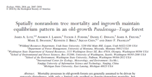
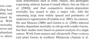
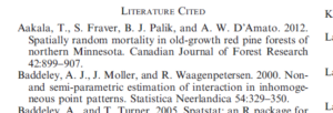
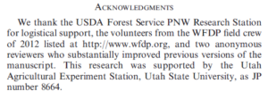
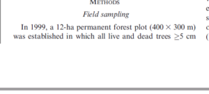
The article I’ve chosen for this exercise is a paper published by the journal Ecology entitled: Spatially nonrandom tree mortality and ingrowth maintain equilibrium pattern in an old-growth Pseudotsuga–Tsuga forest.
The article can be classified as academic, peer-reviewed research material based on the following evidence (images were taken from the paper and provide documentation):
The authors appear to be experts in their fields as proven by their university affiliations, in-text citations, and a literature cited section.
The paper was peer-reviewed by anonynous reviewers whom the authors acknowledged.
It was a research paper: it contained a methods and results section.
The area I have chosen as a field site encompasses roughly 50 hectares of land and lakeside in the Lakes District approximately one hour south of Burns Lake BC. It is located within a couple hundred meters of a relatively small lake called Bickle lake and is partially on private land (permission to access granted) and partially on crown land designated as “Old Growth management area” by the Province. The ecosystem classification of the entire site as per BEC-web is Sub-boreal Spruce dry-cool (dk) with some site series variation. Slopes are minor with some short steep sections directly adjacent to the lake. My area of interest will likely become smaller as I refine my research question but for now I’m looking at several environmental gradients. These include two particular areas which I will describe in the following paragraphs documenting my initial site visits.
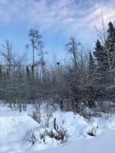
The first area was visited on January 4th, 2021 at around 4:05 pm, accessed by cross-country skiing on the lake. The weather was clear, sunny (sunset) and the temperature was around -1 degree Celsius. Located on a promontory of the lake south of the private property, this section of forest is within the Old Growth Management Area (OGMA) (iMap BC) and has forested lakeside edges that are both north, west, and southwest-facing. Along the north aspect the stand contains large-volume spruce with a good deal of blown-down dead pine (most of the pine in the area was killed by the Mountain Pine beetle epidemic in the early 2000s), which gives way to younger spruce towards the point of the promontory, and then an open aspen-leading stand on west- and southwest facing slopes. I saw old moose prints on the lake and the willows along the shore were browsed so heavily they looked spiky, though the interspersed alder was not browsed. I saw and heard several ravens flying by, but saw no other live animals. A large raptor nest (known from previous summers to be bald eagle-made) was located at the top of a tall aspen, and I saw a cavity nest on an aspen snag at the point of the promontory.
The second area was visited January 7th, 2021 at around 9:05 am, accessed by snowshoe. The weather was calm, partially cloudy, just after dawn and approximately -9 degrees Celsius. Located within the private property north of the OGMA, the site is on the edge between a partial-harvest clearcut (logged circa late 1990s) and the mature mixed forest directly south of it which leads down to Bickle lake. This clearcut is undergoing natural reforestation (it wasn’t planted) and the lakeside is also undergoing a succession process as it was heavily influenced by beaver activity 15-20 years ago. I walked through moose tracks that were left days ago as well as weeks ago. I noticed how spruce and aspen regeneration was occurring in a patchy manner, with dense heavy clumps and strips scattered between sparser strips. Within the adjacent forest were places where criss-crossing immature spruce blowdown cluttered the forest floor, as well as places where larger spruce and aspen had fallen. Was this just natural forest disturbance? Was it related to the “edge effect” of the clearcut? Or could it be that the wind events that have been occurring have been more severe recently? (Due to climate change?) As I walked into the mature forest I felt, saw, and heard the presence of more animal life. I watched a squirrel munching on spruce cones (and it watched me) and heard several squirrel alarm calls. I heard chickadees calling; and I followed the tracks of a small canine – probably red fox. I noticed a large opening with blown-down trees with 5-6 scattered trees broken off at around 5m, some live, some dead.
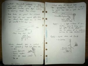
Observations of moose tracks, browse, and squirrel
Three initial questions come to mind regarding my observations:
Why is there an apparent difference in tree species concentrations on different aspects – even within a small “old growth” area? What ecological attributes form the basis of a designation such as “old growth management area,” and can these attributes be measured in differently organized forest stands? (e.g. open aspen stands with heavy saskatoon/snowberry shrub component as opposed to a high-volume spruce stand)
Does the heavy density of coniferous regeneration that appeared to naturally return to a harvested site – similar to the super-heavy pine ingress I’ve observed following a forest fire – provide some sort of stand resilience or biodiversity advantage as succession progresses? I’m comparing Nature’s method of succession to the Industry standard of an evenly-spaced tree crop.
The heavily browsed forage species I observed at first made me question whether there was inadequate browse options to support the local moose population but this goes against local anecdotal evidence which suggests moose populations aren’t at over-capacity. Also, upon further observation, there appeared to be plenty of browse species individuals that were hardly touched by moose. Could plant individuals that were hyper-browsed simply be located in moose thoroughfares and were thus casualties of being “along the main trail?” Or could there be some strategy at play to produce more new shoots on one plant individual, thus decreasing a moose’s need to travel further than otherwise?
The area I have selected to observe is a 1 km2 area in Western Ukraine. The area has been chosen primarily due to its accessibility, multiple environmental gradients and its densely populated communities of various animals. The land consists of a gentle sloped hill descending from south to north with a shallow creek bed and stagnant pond on the western aspect, I have been in this area throughout every day for the past few months so it is easy to observe and document daily and hourly changes and behaviors on a regular basis.
Map of Observation Area
Vegetation
Most of the area consisting of mixed temperate forest, creeks and swamp blending into an urban park with some permanent buildings. The forest consists of primarily mixed types of pine and large old growth oak. The forest floor is a mix of smaller plants and shrubs but is clear enough in most places to walk under the trees without becoming entangled in the brush. Among the scrub brush there are poison ivy plants. In lower areas near the ponds the undergrowth becomes almost impassible with various types of bush like plants such as raspberry. These are fed by the higher water concentration in the thick black soil. The urban area is sparsely populated by cypress, old growth oak and pine trees that initial grew prior to the laying of brick paths between the buildings. The grass, likely a human addition, has grown over a grey sandy soil, in the urban area is maintained once every month or so, but is mostly left untouched unless it is tall enough to go to seed.
Drawings from field journal
Wildlife
There are a number of animals who live in the area. Rarely seen is the Red squirrel, (Sciurus vulgaris) populates the trees, while the moles are predominantly in the sandy area of the urban grass. There are many feral dogs which roam far and wide as new packs enter and exit the observation area as food or mates become sparse. A smaller number of different coloured feral cats (likely not from the same litter) stay in the area to prey on the mice, birds, squirrels and the occasional mole. Of note the only birds seen are seagulls, which have left the area due to winter, and the yellow Parus Major which flits around between the worm rich ground and the thick cover of the cypress and pine trees. Some of the feral dogs have had visibly engorged ticks on them as well. There have been no turtles nor fish seen in the pond but it is not well oxygenated by plants, as it contains a great deal of decomposing leaves from the deciduous trees and very little movement from the tiny creek.
Weather
From October to January the weather has transitioned to cool fall to mild winter. Short periods of light rain showers, and a persistent overcast winter sky are rarely disturbed by any significant wind greater than what could be described as a breeze. Despite the winter season the weather here is mild enough for the temperature to range between an average of -5oc at night to +10oc during the day. It has only snowed three times, and it rarely lasts longer than a day or two before melting away.
Questions
Since none of the dog spoor has been seen anywhere in the area, where do the feral dogs defecate? Is it a centralized location?
The moles appear to continue pushing upward and creating molehills, but I am curious if there may be a correlation between soil temp and activity and or the activity of the prolific earthworms?
Does the predation of moles by cats and dogs effect the location of the mole colonies?
The article can be classified as non-peer-reviewed academic material, specifically for review purposes. The article also includes many in-text citations and a complete bibliography. There was no acknowledgment of the article being peer. Lastly, the article can be easily determined to be review material rather than research material by the lack of a “Methods” and “Results” section.
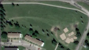
The area that I have chosen to observe is a small city park near my house that is used by both humans and animals, as there is a large open space as well as a playground. I visited the area on Dec 29th, 2020 at 16:00. The temperature was -7 C˚ and the weather was cloudy with a breeze, 4in of snow covered the ground. The park is situated on the side of a residential neighborhood in Brandon, MB. The park is mostly open flat grassland with trees growing in some areas. The size of the park is approximately 400m in length.
The vegetation within the park is open grassland with no shade and no trees, areas with larger trees that provide shade, and smaller trees that were sparsely spaced out. Additionally, it is located by city streets and railway tracks that open up to the rural areas and allow animals such as deers and wild rabbits to roam the residential roads.
3 questions that could form the subject of the project
How does the proximity to a residential area affect the species diversity and richness?
What habitats are usually used by deers?
What biotic/abiotic factors attract these specific animals to the area?
Overall, this field research project has been greatly beneficial to expanding my knowledge and providing me with tools to carry out scientific research, capture field research, analyze data, and present my findings. I found many hurdles along the way, for example, choosing a specific and realistic area to focus on, deciding on an appropriate experimental design and sampling method, as well as, incorporating materials learned in the ecology class and applying them to properly title and document my findings. Deciding on a research question was difficult. I had to weigh both what might be conceptually interesting but what could be practically executed in the field. Moreover, the research question also needed to be previously researched and the hypothesis testable. Other hurdles included physically taking samples and ensuring that bias was removed and data was accurately collected by closely following distance and directional measurements.
This course has broadened my understanding of ecology, as well as, supplied me with the tool kit to further my scientific research in other areas of biology. Engaging in this research gave me insights into how difficult it is to gather data with high validity and rigor and appreciation of the efforts, hard work, and time others exert for their research. In terms of ecological theory, this validity and rigor are critical to developing sound theory and a basis for our basic understanding of the world around us.
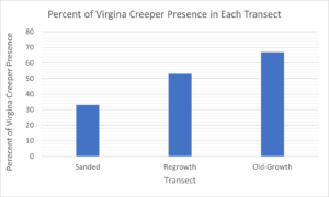
Originally, I struggled to discern the most appropriate way to present the presence or absence of Virginia creeper data that I had collected in my samples. However, once the data was converted to the average of Virginia creeper presence in each transect and presented in a bar graph, the findings became clear and easy to compare. Moreover, while writing my final paper, I found it difficult to present findings that were free of interpretation.
Overall, the findings supported my original hypothesis that Virginia creeper is negatively affected by anthropogenic activity. However, during my research of Virginia creeper characteristics and growth patterns, other underlying processes were brought to my attention such as if Virginia creeper had a stronger presence given a more nutrient-dense soil, in areas that facilitated more precipitation or more sunlight, or how the competition of other plants affected growth. Additionally, it would be interesting to observe the Virginia creeper over a longer period of time to better understand growth patterns in the sanded area and regrowth area. The results in these two areas could potentially differ more drastically and alter my findings if Virginia creeper was given more time to grow and disperse. Finally, it would be ideal to measure Virginia creeper growth in a controlled setting to obtain a better understanding of the impacts of anthropogenic activity on presence versus areas left undisturbed.
Figure 1: Graph of Virginia Creeper Presence in Each Transect
This graph illustrates the percentage of presence of Virginia creeper in the sanded, regrowth, and the old-growth areas.
The theoretical basis of my research project is to determine if Virginia creeper is negatively affected by the presence of anthropogenic activity. The central assumption is then examined in three areas; the first has largely been disturbed by anthropogenic activity as the natural area has been cleared and a road of sand has been built, the second area has moderately been disturbed by anthropogenic activity with some trees selectively removed, and the final area has not been disturbed anthropogenically.
The sanded area differs from the other two areas in that the Virginia creeper has more direct access to sunlight to promote growth and less competition with other plant species for nutrients. However, in this area, Virginia creeper growth can also be inhibited by sections of densely packed sand.
The second area presents the greatest opportunity for Virginia creeper to grow as selective logging clears the overhead canopy providing more sunlight and the removal of the trees presents more soil nutrients and less competition for the vine to flourish.
The final area that has not been disturbed by anthropogenic activity has provided Virginia creeper the greatest amount of time to naturally grow. I have observed that in areas of natural treefall, the Virginia creeper has opportunistically overtaken these areas and has used its adhesive tendrils to climb trees in other areas.
Three keywords: anthropogenic activity, woodland region, Parthenocissus quinquefolia
Initially, to collect samples, I chose a systematic random sampling method by dividing my subject area visually into three transects; a makeshift road, a regrowth area, and an old-growth area. In each transect, I took one replicate, consisting of five samples. A compass direction generator was used to select a direction, then I would walk 10 paces in that direction. At the 10 pace mark, I would use a 1 m2 square or quadrat to frame the area I would collect samples in. In each quadrant, I would record a “1” to represent if Virginia creeper was present or a “-” to represent if there was no Virginia creeper present in that sample. Replicates will be taken at 10:00 am beginning in the sanded area for six consecutive days from November 18th, 2020 to November 23rd, 2020.
In replicates two to six, I will adjust my sampling method to ensure a more exact distance and direction are followed. I will use a measuring tape to ensure the distance is at 10 m and request a friend assist in ensuring that the generated compass direction is followed. To create independence in the replicates, a compass direction generator will be used to provide an equal probability of any part of the transect to be measured and to remove sampling biases.
Ancillary patterns I have noticed are that Virginia creeper plants in the sanded area tend to be smaller plants, consisting of shorter vines or bunches of small sprouts. In the regrowth and old-growth area, the plants tended to be more clustered or quite full and long vines, often climbing up trees in the vicinity. Where shoots were present it was more likely to find a couple small shoots growing in clumps rather than evenly distributed throughout the area. I have also noticed in the sanded area, that some sections of sand are densely packed and in these areas, Virginia creeper is not present. It appears that Virginia creeper is more likely to be present along the edge of the transect or where the sand has been disrupted either by other plants, animal activity, or where water has created depressions and grooves.
 , and I saw a cavity nest on an aspen snag at the point of the promontory.