Recent Posts

Post 2: Sources of Scientific

User:  | Open Learning Faculty Member: 


One of the source of ecological information that I am using is from the Alberta Parks website: https://www.albertaparks.ca/parks/kananaskis/fish-creek-pp/information-facilities/nature/plants/#:~:text=Common%20Plant%20Species,spruce%20forests%20with%20some%20grasslands.

This information is a city managed website that provides updated research material on the nature of various parks located in Alberta. The area that I referred to was for Fish Creek Provincial Park. This source is written and maintained by professionals in the field of ecology. This is confirmed by looking at the requirements necessary for applying to work for Alberta Parks. I know that the sections that I used in regards to Fish Creek are peer reviewed as they provide as list of updates to the webpages with who updated the information and their position within Alberta Parks.

Post 1: Observations

User:  | Open Learning Faculty Member: 


I chose to study to area in Fish Creek that is approximately 3.5km from my home. The area is a stormwater pond that is surrounded by walking paths. This stormwater pond has signs posted that it frequently floods and to keep your distance as a safety precaution.
The main area that I am looking to study will be a region of increasing elevation to the north side of the stormwater pond.
The area consists of grassland areas which are higher elevations and riverine areas that run along the edges of creeks and ponds.

Observations:
I usually run from my house, up to Fish Creek, through a section of Fish Creek that passes by the stormwater pond, and then loop back towards my house.
The stormwater pond is completely surrounded by walking paths which provides an unnatural barrier for vegetation.
I have seen water levels rise and fall in the pond but have yet to see a drastic increase but there does seem to be a distinct line where vegetation density increases. This could be a high point of flood in and around the region.

Some of the vegetation that grows in the area are:
– Cow parsnip
– Asters
– Veiny meadow rue
– Karl Foerster
– Silver sage
– Cotoneaster
– Dogwood
– Aspen trees
– Poplar trees
– White spruce trees
The trees and larger shrubs were not present at all until at least 10 ft past the walking paths uphill except for a couple of spruce trees.
There seems to be a fair amount of human traffic in the area as I have yet to run through that section of the park without seeing other people. There are paths through the grass and brush in some area where people make their own paths or their dogs are left to roam. There was also some construction on the walking path that resulted in some vegetation and trees being removed. These larger trees and shrubs could provide a base for smaller vegetation to thrive in the immediate vicinity.

Blog Post 7: Theoretical Perspectives.

User:  | Open Learning Faculty Member: 


The theoretical basis of my research project is to determine why the geese prefer a particular type of waterbody and grassland over another. The underlying factors that underpin my research of the geese density are- disturbance, weather and the vegetation. The geese prefer the vegetation around the ponds which had common groundsel and common plantain, the soil moisture seemed to support their growth more. There were a lot more trails along the river which had more human activity. And the vegetation was more of grasses and coniferous trees which support other wildlife. This might be the reason why the geese prefer to raise their young and stay around the ponds. It would be safer and more food resources for them. My research keywords will be- Geese Density, Grassland Vegetation and Waterbody.

Blog Post 6: Data Collection.

User:  | Open Learning Faculty Member: 


I collected data for 15 days continuously, it was supporting my hypothesis. I sampled 11 replicates, 5 m around the ponds and along them and the same distance for my spots along the river as well. I counted the number of geese in that space. I also recorded the weather while collecting the data. This was the only way that I could do replication to support my hypothesis. I have noticed positive ancillary patterns that support my hypothesis.

At first I thought my sampling design was Tabular but then after considering my data I decided that it was logistic regression because my response variable is continuous.


Blog Post 4 Sampling strategies

User:  | Open Learning Faculty Member: 


Using the area-based method for community sampling I found the systematic technique to be have the fastest estimated time at 12 hours 35 minutes. In my virtual sample, systematic sampling also had the lowest combined percent error for both the two most common and the two least common tree species.

The most common tree species was Eastern Hemlock, the most accurate result for density was achieved using a systematic approach with a percent error of 14.02%.  The second most common species was Red Maple, the most accurate technique for density was achieved using random sampling at 2.44%.

The least common species was White Pine, haphazard sampling achieved the lowest result in percent error for density at 52.38%.  The second most rare species, Striped Maple, had an accuracy that was the same between systematic and haphazard sampling at 54.29%.

Accuracy was higher for the common species and much lower for rare species as shown in Table 1.  The varying results between all the techniques and the inaccuracies shown through the large percent errors indicates that my sample size was too small. Larger sample sizes would be needed to achieve reasonable results.


Table 1. Summary data for community sampling exercise comparing density using area-based methods.

Species Systematic Random Haphazard
Actual density data Percent error data Percent error data Percent error
Eastern Hemlock 469.9 404.0 14.02% 592.0 25.98% 544.0 15.77%
Red Maple 118.9 128.0 7.65% 116.0 2.44% 140.0 17.75%
Striped Maple 17.5 8.0 54.29% 0.0 100.00% 8.0


54.29%
White Pine 8.4 0.0 100.00% 28.0 233.33% 4.0 52.38%
time 12 hours 35 minutes 13 hours 22 minutes 12 hours 57 minutes


Blog Post 6- Data Collection

User:  | Open Learning Faculty Member: 


      I have begun implementing my experimental design by collecting field data from my study site. As previously mentioned in an earlier assignment, I will be performing 30 replicates total (10 replicates per study site). In order to be finished by module 8 I have chosen to do 10 replicates (1 study site) per module. This week I did my first set of 10 replicates and it went very smoothly. I chose my first location- the elderflower shrub branch. This is the location that is furthest from the road and my prediction is that this location will have the most Western Honeybee pollination activity. I counted the number of honeybees that pollinated the branch over 5 minutes, then repeated this 9 more times. My numerical data was written in my field journal in addition to the time that this data was collected and other pertinent information. As I have only collected data from one treatment site, I cannot comment on whether or not this data is congruent with my prediction because I have no other data to observe it against.

       So far I have not had any difficulties implementing my sampling designs. But I may run into problems in the following weeks. The weather is getting colder and the plants in this community garden are beginning to wilt and become dormant. I am nervous that my other treatments will not be viable by the time I get to observing them. I initially planned on completing this before the cold weather came but due to unforeseen circumstances (involving a glass of water and my laptop!) I was not able to access my modules/experiment information and schedule this experiment as I had initially intended. However, I will remain hopeful for the next 2 weeks and ideally be able to obtain accurate data for this study. Perhaps I will have to choose different plants that are still active in the same location of the treatment sites left. This is unfortunate because I initially had chosen my sample placements because of their similar characteristics. I am hoping that there will be some similar samples left in the locations I am studying during the weather changes.

Blog Post 9: Field Research Reflections

User:  | Open Learning Faculty Member: 


Initially, I had a lot of issues with carrying out my project. I entered this course with a fairly basic knowledge of ecological theory. However, having made it through the course material and reviewing the literature necessary for my final project, I now feel like I (finally) understand the data that I was collecting. As time went on: the course equipped me with the knowledge to relate my observations to an increasing amount of theory. This did not result in me changing my sample design (aside from my initial changes from haphazard to randomly placed quadrats to transects – more information is available on this switch in Blog Post 6); however, it did result in me changing how I viewed my data.


Having noticed that forb species tended to change drastically over a small area, I originally set out to just characterize the forb species that reside along a riparian slope (and was completely ignorant of the patterns or processes that I should have expected to see). Following this, reflection on the underlying mechanisms led me to think that soil moisture would be the single largest factor contributing to forb distribution. I was (partially) correct in that assessment, but had an incomplete picture. As I began to dive deeper into the literature and the course work, the Intermediate Disturbance Hypothesis kept coming up. I then related what I had learned concerning this to my study area. It allowed me postulate that I would likely see a “hump-shaped” relationship of richness and diversity along the elevational gradient of my study. The reason for this was because I expected that the inundation of the river caused disturbance; therefore, the region of maximum disturbance would be at the lowest elevations of my study area, the areas of least disturbance would be at the highest elevations of my study area and the highest richness and diversity would occur somewhere in the middle. However, yet again, I was (partially) correct. Examination of my data revealed a biphasic pattern of richness and diversity (in which there were two peaks). I now understand that this is because disturbance was being exerted on both ends of my study area: river inundation at the lowest reaches, and anthropogenic at the highest reaches. Therefore, the area of lowest disturbance resided in the center of my study area, and areas of maximal disturbance resided at both margins.


As the result of journeying through the development, implementation and analysis of my project: I now have a great appreciation for ecological theory and just how complicated it can be to develop and study. At first glance, my project seemed simple: just go out and count the forbs. However, the amount of variables that were responsible for the patterns that I was seeing are overwhelming. I feel that I have managed to capture a few of the most important ones related to forb distribution along an elevational gradient in a riparian zone; however, I now know that I have only scratched the surface.

Blog Post 7: Theoretical Perspectives

User:  | Open Learning Faculty Member: 


The theoretical basis or aim of my research project is to determine the likely cause of the observed variance in soil texture along a slope gradient in a grassland ecosystem. The theory that I am exploring and forms the parameters for my field data collection include, slope gradient and vegetation type and cover as possible explanatory factors for the observed variance in soil texture. Ideas that underpin my research include the understanding the gravity & water transport finer soil particles further away from steep slope positions then coarser soil particles. Another idea is the role that vegetation plays in determining soil texture in a given site.

Keywords: Soil texture, slope gradient, grassland ecosystem.

Post 3: Ongoing Field Observations

User:  | Open Learning Faculty Member: 


I plan to study Peterson Creek as a viable spawning area for salmon and the effects of the aesthetic grooming of the creek could be having on that population.

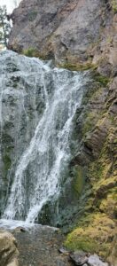
The three locations I chose as my sample areas were at the base of the waterfalls where I noted the finest sediment and largest girth in the stream bed. I observed the gradient of the falls and levels to it, ensuring it was possible for fish to travel from the feeding lake above.

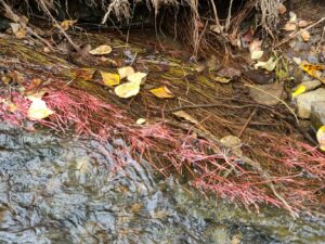
 I then traveled 0.5 kilometers downstream where I had first observed red algae along the edges of the stream indicating a food source and nutrients to sustain fry growth before entering the Thompson River. The rocks were much larger in this part of the creek and the water was much shallower while the walls of the stream were narrow and steep compared to the gradual gradient and deep pools found at the base of the falls.

The final location I chose was the beginning of the park another 0.5 kilometers downstream to see the most heavily traveled portion of the creek. This area has evidence of heavy travel in and around the water by dogs. There was absolutely no visible plant life in the water and around the creek bed was only grass, no shrubs which indicates heavy travel in the area. There were bits of garbage littered  around the tree bases.

The frequent creek bed disturbance by human intervention through methods of removing debris has resulted in the area being uninhabitable for local fish.

The areas of the creek with adequate substrate and width for fish to lay eggs shows evidence of removal of debris. This area will have depleted biodiversity and few if any fish inhabitants.

Based on my hypothesis, the response variable is the salmon population, it is considered categorical. I aim to measure their presence in the creek. The explanatory variable I have identified based on my hypothesis is the people who visit the park. It is considered categorical as I will be measuring their influence on the creek’s biodiversity.

Design Reflection

User:  | Open Learning Faculty Member: 


My sampling strategies went better than I expected during the first few times I went out monitor ant activity. There was obvious ant activity that made the data collection easy. However, I am currently having some difficulties with my method. We have had some bad weather recently that has made any animal or insect activity scarce. Once the weather clears up, I plan to continue my current method of collection. The only modification may make is checking more frequently. I was going out every few days so as to not be too disruptive and cause a fluctuation in the numbers due to human activity. However, the weather this time of year can vary so greatly at any given moment that taking multiple samples a day (before bad weather and after, morning and afternoon etc) may help me acquire better results.  I also need to make sure I wait for it to be warm enough for ants to be out when I go out because some mornings can be cold and have not much activity.

One thing I found surprising is the number of ants changed the day before the weather changed. I went out to collect data and found no ant activity in any of my quadrats. Given the amount I had found previously I was not sure why there was none on the day I went out, especially in areas where the numbers have been consistent.