Recent Posts

Blog Post 1

User:  | Open Learning Faculty Member: 


I have chosen to observe a community Garden in the city. Below are my notes:


Designation: City Park, community garden

Field Journal 03-09-2020

Time: 1247 hours

Date: 03-09-2020

Weather: sunny, clear sky, hot and dry, minimal breeze, 21 degrees celsius

Seasonality: Summer, approaching fall

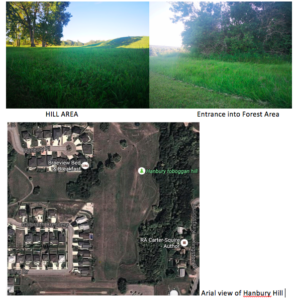
Study Area: Community Garden at 1645 East 8th Avenue Vancouver BC. Latitude: 49.2635 Longitude: -123.0711. Study area is generally small, approximately 2 houses worth of land (~1500 sq. feet)

Location: 2 bee hives located towards northern boarder of area, shed in north western corner and a park bench is located centrally on northern boarder. The Western boarder backs onto a large house, the Northern boarder is contained by a chain-link fence and you can hear the subway train in the distance. The Southern and Eastern boarder are marked by a street (Commercial Dr, and East 8th ave).  There are approximately 12 garden planters, and 2-4 pedestrians visited during my 20 minute stay. Many bees, flies, moths, butterflies observed. 1 bird seen.

Topography: grassy flat, likely human-made

Vegetation: grassland with ~12 large human-made wooden planters containing various vegetation, mostly edible plants (e.g kale, herbs, tomatoes, etc.) and flowers (unidentifiable)

Potential Subjects – Bees and other pollinators

Questions about this observation

  1. Which flowers or plants are most frequently visited and why
  2. Which time of day and during which weather conditions are honeybees most active
  3. Do honeybees prefer human planted vegetation or naturally growing vegetation to pollinate?

Blog Post 5: Design Reflections

User:  | Open Learning Faculty Member: 


My initial data collection day went as planned with implementation of my sampling strategy going quite smoothly. I came across one minor difficulty in that my home-made quadrat from cardboard, although useful, started to lose durability towards the end of the sampling intake due to the ground being moist/wet. As I took 10 samples in total, and my research project requires 20 samples in total, I will need to re-make the quadrat with cardboard and wrap it in plastic, or use a more durable material.

The data results were in support of my initial hypothesis prediction, however, I was surprising in that most quadrats did not have any presence of scat for both areas. I plan on collecting data using the same technique as it was quick, easy, good randomization, and allowed for easy visualization of any scat that was present in the quadrat.

Blog Post 3: Ongoing Field Observations

User:  | Open Learning Faculty Member: 


During my observations on the field – not only on the first day of observation but numerous visits at different times of the day, the difference in animal activity between the two distinct areas fascinated me, especially with deer activity.

July 14th:

  • Time: 6am – 6:30am (dawn)
  • Temperature: 20C
  • Weather: Sunny but partly cloudy. Humidity was 68% (quite high). Wind was ~22 km/hr.
  • Seasonality: Mid-Summer

The number and frequency of whitetail deer seemed to increase the further away from the forest and into the hilly grass terrain. The forest seemed to have a lusher vegetation, a source of water from the creek, and soft earth to frolic. Yet, the whitetail deer seemed to prefer frolicking in the ecotone between the two terrains and preferring to spend their time in the hilly area.  The ecotone had taller grass with a variety of tall grass species, while the hilly area had shorter grass.

Seeing as how deer are animals that move, it is impossible to log their movement 24/7. I decided to track deer activity based on findings of deer excrement (scat).

My hypothesis for this study will be that between two distinct domains (hilly area and forest), whitetail deer activity will be higher in the open, big, grassy area. My prediction for this research is based on observation of live whitetail deer in that area, and the possible underlying processes, such as:

  • The soil and grass type that grows on the hilly area provides a richer nutrient pallet for the deer so they prefer to feed from this area. With a greater surface area than the hilly area has higher abundance as a food source
  • The open-area of the hilly area allows for better visualization of any approaching predators

Hence, why there might be more deer activity in the hilly area compared to the densely forested area. My prediction for this research is that more deer scat, that will indirectly measure deer activity, will be found in the open hilly area. I am choosing to assume that distance away from the ecotone that divides these two terrains will not play a factor, hence deer activity should be equal from the edge to the middle of each terrain.

The hypothesis for my research study will be evaluated by the effect of the predictor variables (two habitats based on different spatial arrangements: Hilly grass area & Dense Forest area) on the response variable (if scat is present in quadrat & number of piles of deer scat present in each quadrat). By gathering data on these two variables with numerous repeats and samplings, I am hoping I will be able to determine within which terrain are whitetail deer more active. Considering that both the response and predictor variable are categorical I will use a tabular (two-way contingency table) design with equal-sized quadrats for my design.


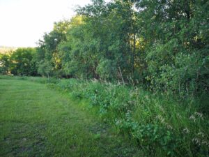
Border dividing the 2 areas of interest
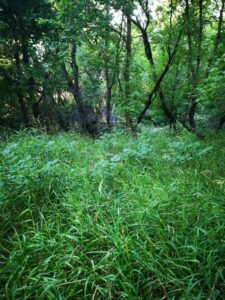
Forest Area

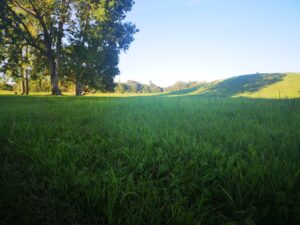
Hilly open grass area

Blog Post 4: Sampling Strategies

User:  | Open Learning Faculty Member: 


In the Virtual Forest tutorial, using Distance-based sampling methods:

Table 1. Comparison of three distance-based sampling strategies; actual, random, and haphazard used to calculate the abundance of seven tree species (Eastern Hemlock, Sweet Birch, Yellow Birch, Chestnut Oak, Red Maple, Striped Maple, and White Pine) in the Snyder- Middleswarth Natural Area.

Tree Species
Strategies Eastern Hemlock Sweet

Birch

Yellow

Birch

Chestnut

Oak

Red

Maple

Striped

Maple

White Pine Est. Time to sample
Actual 469.9 117.5 108.9 87.5 118.9 17.5 8.4
Systematic 277.3 109.6 70.9 38.7 90.3 45.1 12.9 4hr 18min
% error 40.99 6.72 34.89 55.77 24.05 157.71 53.57
Random 441.8 144.1 105.6 115.2 86.4 28.8 0.0 4hr 40min
% error 5.98 22.64 3.03 31.66 27.33 64.57 100
Haphazard 485.0 121.2 83.9 93.3 74.6 18.7 18.7 4hr 38 min
% error 3.21 3.15 22.96 6.63 37.26 6.86 122.6

Based on findings from Table 1:


Which technique had the fastest estimated sampling time?

The times between the 3 sampling strategies were somewhat similar, with the fastest strategy by ~20 minutes being the systematic approach in regards to sampling 24 plots.

Comparing the % error of the different strategies for the two most common and two rarest species. For each species the most accurate strategy was as follows:

  • Eastern Hemlock (most common species) most accurate strategy:   Haphazard 
    • It surpasses the random strategy with an % error of 3.21.
    • Than random & haphazard strategies were more accurate than the systematic, as the systematic had an % error of 40.99.
  • Red Maple (second most abundant species) most accurate strategy: Systematic 
    • This strategy had a 24.05% error.
  • White Pine (rarest species) most accurate strategy: Systematic .
    • Even though it had a 53.57% error, it is far more accurate than the random & haphazard strategies with % errors of 100, and 122.6, respectively.
  • Striped Maple (second least abundant species) most accurate strategy: Haphazard.
    • This strategy had a 6.86 % error which is very low, especially when compared to 64.57% and 157.71% errors for Random and Systematic, respectively.

Did the accuracy change with species abundance?

When comparing all three strategies regardless of tree species, accuracy decreased as species abundance lowered. Therefore, I recommend that more samples than 24 need to be taken to increase accuracy. The majority of % error was inversely proportional to the actual species abundance (save for a few data points), regardless of the sampling strategy.

Was one sampling strategy more accurate than another?

Haphazard strategy had an average % error of 28.96, which is lower than that for Random & Systematic (36.46% & 53.39%, respectively) – there by being the most accurate sampling strategy in a forest terrain. The random strategy being the least accurate.

Blog Post 2: Sources of Scientific Information

User:  | Open Learning Faculty Member: 


Through the Wiley Online Library, I found the source of ecological scientific information I wish to use. I have chosen a journal article titled “Killer Whales (Orcinus orca) feeding on lumpfish (Cyclopterus lumpus) in northern Norway”, published in the journal of “Marine Mammal Science”. Press following link to find the article: https://onlinelibrary.wiley.com/doi/full/10.1111/mms.12618

I have also attached it as a PDF:

Blog Post 2

To classify this article, I followed the following chart:

Does the information source have all the following characteristics?

  1. Written by an expert in the field? Yes. A few of the authors are from the Universite de Montpellier and can be considered experts in their field.
  2. Does the source contain in-text citations? Yes. The authors use numerous in-text citations in their introduction to provide relevant background information and in their discussion to support and contrast their findings with past literatures.
  3. Contain a bibliography? Yes. Reference section begins on page 12 of article.

Since the article has YES to all three questions it can be classified as Academic Material.

Has the source been reviewed by at least 1 referee before publication?

Yes, this article had three anonymous reviewers (mentioned in Acknowledgments on page 11). Since the article is YES to being reviewed it is considered peer-reviewed.

Does the source report results of a field or lab study completed by the authors (containing “Methods” and “Results” sections)?

Yes. This article has a methods, data analysis, results, and discussion section. It can be considered Research Material.

 In Summary:  ACADEMIC – PEER-REVIEWED – RESEARCH MATERIAL

Citation:

Jourdain E, Karoliussen R, de Vos J, Zakharov SE, Tougard C. Killer whales (Orcinus orca) feeding on lumpfish (Cyclopterus lumpus) in northern Norway. Mar Mam Sci. 2020;36:89–102. https:// doi.org/10.1111/mms.12618

Blog Post 1: Observations

User:  | Open Learning Faculty Member: 


The area I have selected for my project is in the middle of the prairies in Brandon, Manitoba. The area’s location I have chosen has a few natural trails, a creek, and two distinct terrains with an immediate ecotone between the two. The first terrain is a forestry area with a gentl, slow flowing creek running down the middle, immediately adjacent to it is the second terrain a not-very steep hilly open grass field. Both these terrains are within an area classified as Hanbury Hill Park and are classified as a recreational-protected area. The Park is about 200 meters from a residential road.

My first visit to this location for observational purposes in regards to designing a study question:

  • Date: July 10th, 2020
  • Time: 5:30pm – 7:30pm
  • Altitude:
  • Temperature: 25C
  • Weather: Sunny, Clear skies, few clouds, slightly windy.
  • Seasonality: Summer

The size of area of interest:

  •             Hilly Grass Area: 20 yards
  •             Forest & Creek: 5 yards
  • Total area that will be studied: 25 yards

Observations:

Topography- Hilly Grass Area:

In terms of vegetation, the hill area has long grass species (~82 cm in height) with little variation, and is cut by the city once every month. There are a few trees very far apart from each other. The slope of the hill is not very steep ~20-degree angle at most on certain elevations. At the bottom of the hill is an outdoor Olympic sized track with few people running on it.

Species Observed:

  • Very few species of grasses
  • Gophers (& gopher holes)
  • Birds: crows and little sparrows
  • Deer
  • Grasshoppers
  • Ants
  • Occasional human walking or running past

There are a few biking trails pass through this area into the forest & creek terrain.

Topography – Forest & Creek Area:

This area is covered in numerous trees densely grown. Heavily shaded undergrowth due to the lush canopy of leaves provided from the trees. Trees and grass/shrubs in undergrowth are fully green and in bloom. The little creek has clear water slowly, and trickles down the creek that has rocks as its base.

Species Observed:

  • Very few species of trees
  • Deer
  • Some type of birds
  • Frogs
  • Humans (if you count myself and my lab assistant)

AREA OF OBSERVATION

Main Questions:

  1. What kind of species of gophers reside in the hilly area, and why are they not found in the Forest & Creek area?
  2. Is there more Deer activity in the hilly open grass area than the dense forest?
  3. Have the trails created by bikes influences how the animals and terrain interact with each other?

Blog post six – Data Collections

User:  | Open Learning Faculty Member: 


There were a total of thirty species being considered for the study. Some of the ancillary patterns which reflects on the hypothesis indicated that the average of the number of birds in every hectare was the sum of the estimated density in all the species. The grams of the birds per Ha was the sum of all the species then multiplied by the average body mass of the species.