Recent Posts

Blog Post# 2: Sources of Scientific Information

User:  | Open Learning Faculty Member: 


a) Source: Article on “Social and Ecological High Influential Factors in

Community Gardens Innovation: An Empirical Survey in Italy

Rusciano V, Civero G, Scarpato D. Social and Ecological High Influential Factors in Community Gardens Innovation: An Empirical Survey in Italy. Sustainability (Basel, Switzerland). 2020;12:4651.

b) This source is an Academic peer reviewed-research material

c) –Academic because it is written by experts in their field, and their article have in-text citations, and references at the end. Authors: Vincenzo Rusciano, Gennaro Civero and Debora Scarpato * are connected to the Department of Economic and Legal Studies, University of Naples Parthenope. Also see a picture below.

Peer-reviewed: In the Author contribution they mention the reviewers of the article. See evidence below.

“Author Contributions: Conceptualization, D.S.; Founding acquisition, D.S.; Investigation, V.R.; Methodology,V.R.; Project administration, D.S.; Supervision, D.S.; Validation, G.C.; Visualization, G.C.; Writing—original draft,G.C., V.R.; Writing: review & editing, C.G., V.R.; All authors have read and agreed to the published version of the manuscript.” copied from the article.

-Research material because the paper is comprised of methods, as well as the results of the study. In methods they used sampling, interviews and questionnaires. And multiple tables were used in the presentation of data. Here is one of the tables used in the results section.

Also, see from pages 5-11 for evidence of methodology and results from the article.

Blog Post #1: Observation

User:  | Open Learning Faculty Member: 


The study area I have chosen is Duggan Community Garden located in Edmonton, AB. Visited in the summer season on July 15, 2020. I was at the site from 12:12pm to 1:03pm. It was 14°C, windy, cloudy and sunny on and off.

Physical description of the area:

The garden is 51.7m2 in perimeter and 114m2 in area. It is flat, with 15 garden beds, each bed containing different species from the others. Some garden beds were monoculture, but most of them were polyculture. The garden is surrounded by a compost area, grassland with a variety of ornamental trees, a community playground, and street roads. The 5 most common species planted in the garden are the beans (Phaseolus vulgaris), tomatoes (Solanum lycopersicum), pumpkins (Cucurbita moschata) carrots (Daucus carota), and lettuce (lactuca sativa). Below are the figures that demonstrates more details of the garden area.

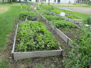
Figure1 : Overview of the study area, which is flat (Duggan Community Garden) with a variety of plant species.

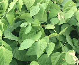
Figure2: Fresh green beans’ leaves with different colour consistency, some are turning yellowish, others becoming dry.

Figure3&4: Pumpkin plants flowering, on the right. However, as can be seen on the left some are starting to change colour, drying.

Figure5: Most grown tomatoes in pots, they are also flowering and bearing fruits.

Figure6: A Bee flying near the flowers.

As seen on the figures above some species have started flowering, especially the tomatoes and the pumpkins. With pumpkins showing relatively large flowers, with different consistency. Some are starting to develop, but others have matured. Unlike the pumpkins, the tomatoes have very small flowers.

The leaves of the plants are all green; however, there is uniformity especially in the beans and pumpkins’ leaves. In one particular garden bed the leaves were green, while in the other the leaves were turning yellowish. This made me ask a lot of questions. To what extent are the beans leaves’ colour affected by the abiotic factors in the surrounding environment? Could it be the different kinds of soil or compost used, could it be the days those beans were planted? These are questions I am looking forward to explore. Some leaves also had holes in them, could it be an indication of insect predators in the area? Could it be a result of the rain and hail that recently fell in this area? To what extent are the abiotic factors in the surrounding environment leading to leaves damage?

I also noticed a cluster of bugs in the area, as well as a few bees. I saw about 3 bees, and they would stick on the flowers for about 10 seconds, then fly away. They were more attracted to fly near the colourful flowers (see figure 6).

Finally, this garden had a number of evidences for human activity in the garden that would have an influence on the growth of plants in the garden. Some indication include the posters in the garden, the compost area, garden beds, and tomato pots.

Questions for a research project

  1. To what extent do the abiotic factors in the surrounding environment affect the change in colour of the beans leaves? and to what extent are the abiotic factors in the surrounding environment leading to leaves damage?
  2. How is the plant growth such as tomatoes affected by the pot?
  3. What are the main benefits of practicing monoculture and polyculture to the environment?

Blog Post #2

User:  | Open Learning Faculty Member: 


My source of ecological information is on Beaver Assisted River Valley Formation. The link to this scientific source is: https://onlinelibrary.wiley.com/doi/10.1002/rra.1359

This information source is academic peer-reviewed research material. I know that it is an academic source because it is written by experts in the field (writers are affiliated with a university), it includes in-text citations, and has a bibliography. I know that this source is peer-reviewed as the acknowledgements thank Kevin Devito, Jill Johnstone and two other anonymous reviewers for their comments on their early draft. Finally, I know that this is a resource source because it reports the results of a field study (has methods, results, discussion; etc).

Blog Post #1

User:  | Open Learning Faculty Member: 


The area I have chosen to study is in Dawson Creek, BC. I am studying the forest and creek alongside the Dawson Creek walking trail. The creek winds through the walking trail and goes through the city park. My area of study starts near the Dawson Creek Public Library and continues through Kin Park. The Dawson Creek trail follows the creek for about 4.5 kilometres.


My first trip out was on 14/07/2020 at 9:50. It was about 20°C out and sunny. There was a little bit of wind. 

The main area of the creek I focused on was behind the public library. This area is in walking distance of my home, making it a convenient place for me to study.

The creek was low, despite the extreme flooding there was last week. The steeper areas of the creek bank are free of vegetation. All of the plant life on top of the slope is in full bloom.

Observations:

I observed a couple of beaver dams, which led me to wonder what time of the day I was most likely to spot a beaver. I also wondered if they were more likely to chew down certain trees rather than others.  I saw a few tree stumps that had chew marks in them. I also saw a bunch of mud by the creek that had been walked over, but I couldn’t make out any obvious footprints.


Next, I observed some flowers with bumble bees on them, which lead to me wondering whether or not they were more likely to pollinate certain flowers rather than others. I also noticed that the blooming flowers were pointing toward the creek and  I wondered whether or not there was a reason for this. Some flowers/planst I observed were:

  • Prickly Wild Rose (Rose acicularis)
  • Western Aster (Symphyotrichum ascendens)
  • Wild Lupin (Lupinus Perennis)
  • Cows Parsnip (Heracleum maculatum)

I observed some Cows Parsnip by the creek. They became more abundant as I got closer to the creek. I have heard that the sap inside of these can cause burns. The plants I saw and measured were around 58 inches tall.

I could hear lots of birds, but saw very few. Three birds that I saw were the:

  •  Black-billed magpie (Pica hudsonia)
  • Small Brown Bird (Unsure of species)
  • Crow (C. caurinus)

Due to my study area being near the public waking trail and park, there were many signs of human activity. There were plenty of human-made trails that went down to the creek.

Some potential study subjects for my project are:

  • Beavers (Caster canadensis)
  • Bumble bees (Bombus spp.)
  • Giant hogweed (Heracleum mantegazzianum)
  • Black-billed magpie (Pica hudsonia)

Three questions that could possibly help to form the subject of my research project are:

1. Do beavers have a preferred tree species? How is tree selection changed by availability and human activity? What effect do beavers have on the surrounding environment due to their activity? How does flooding effect them?

2. Which wildflowers are bees most likely to pollinate? Is there a specific species or colour that they are more attracted to?

3. Why is there fewer signs of vegetation near the water? It gets slightly less green as you go further down the slope. The giant hogweed, however, becomes more abundant as we near the creak. What is it that makes this species better suited to survive than every other species in the area?

Scan of my field journal:

Scan


Blog Post 6: Data Collection

User:  | Open Learning Faculty Member: 


I have had an interesting time collecting data in comparison to how I collected it in the field back earlier in the year. Collecting data using iNaturalist has been somewhat faster, however it does take time how to use it effectively and collect the data that I want. I have been able to collect 87 unique data points of bryophyte sightings located in various locations and elevations at the park. It has been difficult implementing my original sampling design since I am not able to physically collect my own data, so I have to work with what has already been collected. I have noticed patterns in species composition between the upper and lower portions of the park, but this will require further investigation as I begin to organize and analyze data. I plan to choose three to four bryophytes to perform the analysis on, due to the diversity of sightings recorded on iNaturalist.

Blog Post 4-Sampling Strategies

User:  | Open Learning Faculty Member: 


Blog Post 4: Sampling Strategies

Using three sampling strategies in the virtual forest tutorial for the Snyder-Middleswarth Natural Area, the “simple random” sampling technique yielded the fastest sampling time. I would consider more than 24 plots, as I feel more data might yield more accurate results. I feel that the accuracy of the abundance is not enough to form any conclusions-I would increase the number of sample points for both.

(E-T)/E*100=percentage error

Rarest Species:

Eastern Hemlock Distance: Simple random Distance: Systemic Distance: Haphazard
PERCENTAGE ERROR 53% 3% 25%
Sweet Birch Distance: Simple random Distance: Systemic Distance: Haphazard
PERCENTAGE ERROR 84% 82% 11%


Most Common Species:

Striped Maple


Distance: Simple random Distance: Systemic Distance: Haphazard
PERCENTAGE ERROR 105% 100%


8%
White Pine Distance: Simple random Distance: Systemic Distance: Haphazard
PERCENTAGE ERROR 327% 100%


100%


The most accurate sampling method was haphazard for both the rarest and the most abundant.  Accuracy appears to decrease with species abundance.

The haphazard method appears to yield more accurate results. While the times vary considerably:

Random: 1 hour, 24 minutes

Systemic: 4 hours, 59 minutes

Haphazard: 4 hours, 31 minutes

I might consider the random technique if I had a small team and a large distance to cover.

Blog Post 3: Ongoing Field Observations

User:  | Open Learning Faculty Member: 


Blog Post 3: Ongoing Field Observations
I have decided to do a presence/absence study of frogs, in 5 locations in a 251.54 km² area of Prince Edward Island.
Prince Edward Island has been farmed for over 200 years, removing over 90% of its natural Acadian forest throughout the 20th century. Since the 1990s, there has been more of an emphasis on restoring native, Acadian species to the land, increasing buffer zones to protect waterways, and increased monitoring of the native species on the island. Many areas have undergone restoration to increase native species and restore fish passages that had been previously cut off from poor management practice like hanging culverts and filling in ponds. The field of study are five locations within the south shore of Prince Edward Island. All these areas are under some kind of management, and some have had considerable restoration work. Others have been left alone; however, they are all near active farming sites, as farming makes up a third of the industry on Prince Edward Island, covering 42% of the island. Based on location to farming sites, I expect to see/hear more frogs the farther they are from active farming sites. Heavy nitrogen and phosphorous levels may impact the number of breeding individuals at a site. I fully expect to see/hear frogs throughout the breeding season, however, I predict they will be more abundant in sites with less effluent from farming. I plan on returning after sunset for 5 locations every two weeks to collect audio and other data from the sites.

assignment 1-data set
Response Variable: Presence of frogs
Explanatory Variable: Categorical next to farms; Continuous-time and date of study
Reference:
https://www.princeedwardisland.ca/en/information/agriculture-and-land/agriculture-on-pei

Blog Post 3: Ongoing Field Observations

User:  | Open Learning Faculty Member: 


The biological attribute that I want to study is soil, specifically soil texture along a slope gradient.

During my site visit to the grassland area I noticed that the site was distinctively broken into two zones: a steep slope section and a gentle slope section. The steep slopes are ≥ 25% while the gentler slopes are ≤ 18%. I decided to capture this transitional gradient by selecting 2 plots on the gentle slopes and two plots on the steep slopes to observe the soil textures in these two different slopes.

In texturing the four soil samples along the gradient I found that the two plots on the lower slope were both Silty Loam textures while the steep slope plots were both Sandy Loam textures. The higher percentage of sand in soil, the courser the soil.

Initial Hypothesis and Prediction: My hypothesis is that Slope % impacts soil texture results. My prediction is that the steeper the slope percent, the courser the soil texture results will be. Specifically, I predict that slopes ≥ 25% will have higher percent sand compared to slopes ≤ 18%.

Note: Vegetation type and vegetation cover can also impact soil texture, therefore I will be collecting data on both of these variables at each plot in subsequent data gathering.

Blog Post 3


Response Variable: Soil texture (Continuous)

Explanatory Variable: Slope % (Continuous), Vegetation type (Categorical), Vegetation Cover (Continuous).


References: Soil Triangle – https://governmentofbc.maps.arcgis.com/apps/MapJournal/index.html?appid=bfebc043b5a546deb9d381e36742407d


Blog Post 5 – Design Reflections

User:  | Open Learning Faculty Member: 


The initial collection of my data began with deciding how large I wanted to set my transect and the degree of information that I want to convey. I used a random sampling strategy so picking an area to sample was not difficult. At first, I wanted to make five-meter transects running perpendicularly into an ecotone, and then split the five-meter section into 1m2 quadrats. Upon walking the transect I quickly found out that this would be too small, and adjusted by stretching my transect into a fifteen-meter transect.

My sampling strategy is to use cover class and average height within a m2 transect to help express the density and health of Himalayan blackberry within an ecotone. At first, I had trouble with being too methodical in taking average heights of plants. I would record four individual heights within a quadrat and then average the four numbers. I quickly learned that this was going to take too much time. I decided to note the three highest sprouts or patches, and then take an average height of these. For cover class I used six different categories ranked one through six (0-5%;5-25%; 25-50%; 50-75%; 75-95%; 95-100%). Moreover, when recording my data would also try to identify each plant’s species within the differing ecotone zone, but upon reviewing my notes I thought that this may have been outside of the scope of my research.

I also made a physical transect line via flaggers tape with one-meter quadrats sectioned off. I was able to string this along two pathways in my backyard, but have a feeling this will be hard to replicate in the field with growing blackberry vines. For this reason, I decided to replicate 1 m via a large stride, and then each stride I walked would be equal to one transect.

Blog Post 4- Sampling Strategies

User:  | Open Learning Faculty Member: 


Blog Post 4:

For this sampling exercise, I studied the 154-ha Mohn Mill area located within Pennsylvania at elevations that range between approximately 420 to 570 m ASL. Steeply dipping slopes make up the topography of the area and sandy loams cover the slopes. During the sampling exercise, I used three techniques that included systematic, random, and haphazard sampling. The results from the three sampling methods are as follows and show percent error data from the two most common and most rare trees.

Using random sampling methods Red Maple (RM) and Witch Hazel (WH) came up as the most dominant species. After 20 quadrats were sampled percent error for each showed errors of 1.98% and 26%, and a total time of 10 hours and 33 minutes was taken to sample. The two most rare species were black cherry (BC) and American basswood each having errors of 566% and 566% respectively.

Using haphazard sampling methods RM and WH came up as the most dominant species. After 20 quadrats were sampled percent error for each showed an error of 14.14% and 49%, and a total time of 10 hours and 34 minutes was taken to sample. The two most rare species were downy juneberry (DJ) and BC each having errors of 201% and 233% respectively

Using systematic sampling methods RM and WH came up as the most dominant species. 24 quadrats were sampled and systematically spaced 50 quadrats from one another. Percent error for each showed an error of 4.21% and 37%, and a total time of 12 hours and 22 minutes was taken to sample. The two most rare species were DJ and white pine and white pine each having errors of 57% and 67% respectively

Observing the results shows that RM and WH are the most common species. Out of the three methods random sampling produced the least percent error (1.98%, 26%), and I suggest that this is the most accurate method. RM appeared to have the lowest percent error in all three methods (1.98%, 14.14%, 4.21%). This could be an artifact from the actual data and more current analysis may have to be undertaken. Another observation includes percent error increasing with diminishing abundance of species with BC (566%, 233%) and DJ (201%, 57%) having the largest error and least recorded abundance. This concludes that accuracy in all three methods increases with the availability of species to sample and random sampling was the most accurate method for sampling. Moreover, systematic sampling took the longest to complete and haphazard and random took similar amounts of time.