Recent Posts

Blog Post 2: Sources of Scientific Information

User:  | Open Learning Faculty Member: 


The source of ecological information that I have chosen is a journal article titled “Cross-scale dynamics in community and disease ecology: relative timescales shape the community ecology of pathogens” and it is available at the following link: https://esajournals-onlinelibrary-wiley-com.ezproxy.tru.ca/doi/epdf/10.1002/ecy.2836. The journal article can be classified as “academic, peer-reviewed, research material” (as defined in Module 1).

The article is “academic” because it is written by experts (given that the study is associated with the Department of Ecology, Evolution, and Behavior at the University of Minnesota), in text citations are present, and a “Literature Cited” section is included.

The article is peer-reviewed. No acknowledgment of referees is included in the article. However, a reference to the corresponding editor (in addition to received, revised, and accepted dates of Feb-8-19, May-15-19, Jun-25-19, respectively) is included. Furthermore, the official website for the journal, Ecology, indicates that it conducts peer review and provides instructions for manuscript submissions.

The article can be considered research material because it includes “Methods” and “Results” sections. In addition, while the article’s authors use existing models to derive their methods, they run their own, novel simulations to acquire data. Therefore, the work related to this article could be described as experimental.


Reference List:

Read full aims and scope [Internet]. c2020. Washington, DC: Ecological Society of America; [accessed 2020 Jun 9]. https://esajournals.onlinelibrary.wiley.com/hub/journal/19399170/aims-and-scope/read-full-aims-and-scope.

Strauss A, Shoemaker L, Seabloom E, Borer E. 2019. Cross-scale dynamics in community and disease ecology: relative timescales shape the community ecology of pathogens. Eco [Internet]. [2020 Jun 9]; 100(11):e02836. Available from: https://esajournals-onlinelibrary-wiley-com.ezproxy.tru.ca/doi/epdf/10.1002/ecy.2836 DOI: 10.1002/ecy.2836.

Blog Post 1: Observations

User:  | Open Learning Faculty Member: 


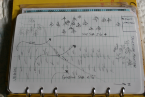
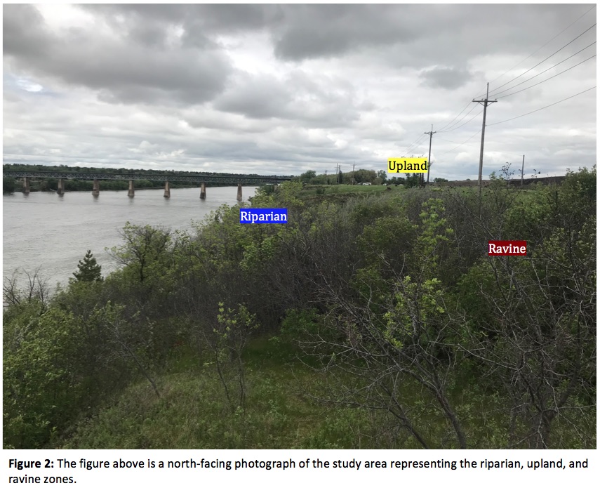
The area that I have chosen to observe is a narrow stretch of civic land (approximately 38 576 m2 in size) located between the University of Saskatchewan and the eastern side of the South Saskatchewan River in Saskatoon Saskatchewan. The coordinates of the South-most point of the study area are 52.135543, -106.641408 and the coordinates of the North-most point are 52.140488, -106.639792. The site was first visited between 1515 and 1850 on June 7, 2020. During the visit, the weather was overcast with sporadic drizzle, high winds, and a temperature of 14OC. Observing the area revealed that there are three distinct areas (the riparian zone, the uplands, and the ravine) (Fig. 1, Fig. 2) divided by their elevation, vegetation, and vertebrate species. The uplands sit approximately 20 meters above the river surface and transition to a riparian zone over a steep bank. Furthermore, a ravine (serving as a swale for the University of Saskatchewan) resides in the northern region of the study area.

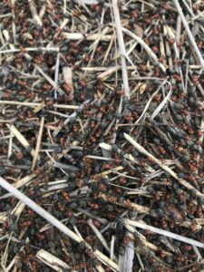
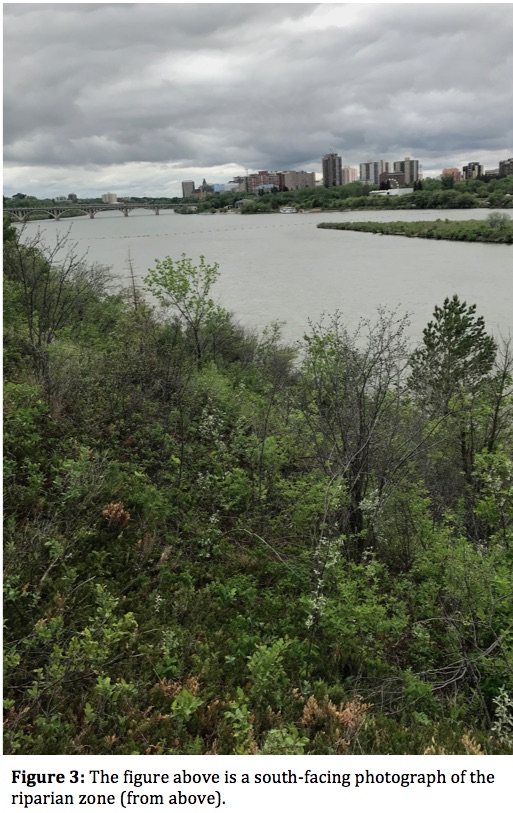
The riparian zone is extremely overgrown and contains many unmaintained footpaths that wind down towards the river (Fig. 3). The area exhibits a high level of species richness in vegetation including a high abundance of Vicia cracca (tufted vetch), Juniperus spp. (juniper), Gaultheria hispidula (creeping snowberry), and Vaccinium vitis-idaea (bog cranberry) making up the underbrush. Meanwhile, Pinus spp (pine), Picea spp. (spruce), Acer negundo (box elder maple), Ulmus americana (American elm), Amelanchier alnifolia (Saskatoon berry), and various Prunis species are the primary components of the canopy. Very few arthropods were observed (likely because of the high winds, cool temperature, and high precipitation throughout the week leading up to the visit of the site). However, scarring and galls (including Cynipid wasp galls) on leaves throughout the area indicated that there is an insect presence. In addition to vegetation and arthropods, Canadian geese, ducks, and various songbirds could be seen throughout the riparian zone.

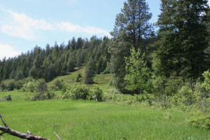
The upland region of the study area is flanked, on the eastern side, by a paved walking path (the Meewasin Trail) that has several meters of grass cut around it. Beyond the cut grass is an area characterized by (mostly) low-lying wild flowers, grasses, and shrubs (Fig. 4). Aside from grasses, the dominant vegetation species appeared to be Saskatoon berry, Elaeagnus commutata (wolf willow), and Astragalus pectinatus (narrow-leaved milkvetch). Similar to observations in the riparian zone, very few arthropods were observed in the uplands. However, multiple ticks (likely Dermacentor variabilis) and indicators of insect foraging were present on vegetation. Anecdotally, the abundance of Cynipid wasp galls appeared to be higher in the uplands than the riparian zone. In addition, there were fewer songbirds observed in the uplands than in the riparian zone. Furthermore, aquatic vertebrate species were replaced with Corvus corax (ravens), Corvus brachyrhynchos (crows) and Pica hudsonia (magpies). In addition, many Urocitellus richardsonii (Richardson’s ground squirrels) were present in the area.

The final area to be observed in the study region was the ravine. As the remnants of equipment and a placard close to the location indicate: it used to serve as a ski hill. The area now serves as a swale for the University of Saskatchewan. A shallow creek runs through the bottom and the area is surrounded by dense vegetation that is mostly composed of box elder maple, Caragana, and Populous balamifera (balsam poplar) (Fig. 5). The interior area of the ravine, superficially, appeared to have it’s own vegetative composition. However, as the ravine extended towards the river, it adopted a vegetative structure similar to the riparian zone. In addition, there appeared to be a high level of black knot fungus infecting the trees of this region.

Questions:

  1. Does the species richness or biodiversity in plants change as the upland region transitions to the riparian zone? Anecdotally, this appears to be the case; however, I am curious to see if it is statistically significant and if this varies between individual species. It was particularly interesting to see how the various species of vetch and milkvetch varied as I descended the riverbank.
  2. Do the incidences of disease or parasitism change from area to area? The abundance of Cynipid wasp galls, and black knot fungus seem to vary based on the region.
  3. Despite the transition area from the riparian zone to uplands being extremely narrow, it seemed like an extreme coincidence that I observed no corvids in the riparian region. Therefore, I would like to know if the bird species vary between these areas.


REFERENCE LIST:

Google Maps [Internet]. c2020. Canada: Google Maps; [accessed 2020 Jun 7]. https://www.google.ca/maps/@52.1379795,-106.6406591,615m/data=!3m1!1e3

Post 1: Observations

User:  | Open Learning Faculty Member: 


The area I have selected for my project is in Kananaskis Country in Alberta. This area has development of trails, recreation sites and highway 66 going through it. The location I have chosen is the Elbow River boat launch location on the South side of the highway and the Ing’s Mine trail area on the North side of the highway. Highway 66 going through the middle shows quite a gradient in the landscape. Both of these sites are within Kananaskis Country and are designated as Provincial Recreation Areas (PRA’s).

My first visit to this location was on 23/05/2020 at around 13:30hr. It was 7 degrees with wind and low cloud coverage hiding the surrounding mountains. The plants seemed to be in the beginning stages of blooming and the water level of the river was quite high due to spring melt.

The Elbow River boat launch location had a 500m trail heading West along the Elbow River. On the South side of the river there was a large rock wall. At the end of the trail along the North side there is about an 80% slope that has evidence of rock slides from the floods in 2013, as well as game trails along it. The elevation at the top of the slope was 1470m and it was South West facing at a bearing of 207 degrees. The Ing’s mine trail was at the same elevation on the North side of the highway. The terrain was flat other than the surrounding mountains.

Observed Species:

  • Kinnikinnick (Arctostaphylos uva-ursi)
  • Pine (unsure of species)
  • Birch
  • Bighorn Sheep (Ovis canadensis)
  • Canadian Geese (Branta canadensis) 

I found little variation in tree species and would like to look into whether this is natural or if the area has been previously logged? As well, there were two geese floating down the river with four goslings between them. At what age do the goslings go off on their own? The Kinnikinnick plant seemed very common in this location. What are some limiting factors of this species?

(Kinnikinnick could potentially be subject for research)

View from top of slope at Elbow River boat launch (South side of highway)

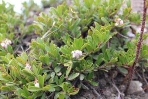
 Arcstaphylos uva-ursi

Blog 1: Observations

User:  | Open Learning Faculty Member: 


The area I have selected for this research project is a transitional zone between a grassland and forest landscape located in Vernon BC. Despite this site being undeveloped and natural it is in close proximity to adjacent property development. I first visited this site on June 6th 2020. It was a sunny 10 degree morning.

The size of the study area is approximately 5000m2 with an elevation of 750m. The slope aspect is East and on a continuous 16 % slope in which the grassland meets the forest. There is also a steeper section of forested landscape that ranges from 60 to 80% slope. It falls within the Interior Douglas-fir BEC zone classification for ecosystems as indicated on iMapBC.

Observed Tree & Shrub Species:

  • Pseudotsuga menziesii
  • Pinus ponderosa
  • Populus tremuloides
  • Pinus contorta
  • Amelanchier alnifolia
  • Symphoricarpus albus
  • Rosa gymnocarpa

Observations:

While comparing the vegetation and ecosystems variance on this site I noticed that the lush grassland was primarily restricted to the more gentle slopes (<16 )where as the adjacent steep slopes (> 60) was an open forest type ecosystem composed of Fd and Py. On another note, I noticed that in the short time I was on site there was considerable mix of complete calm with occasional gusts of heavy wind. I suspect that the topography plays a role in funnelling the wind alongside this mountain. I also found what I assume to be the femur of cow adjacent to edge between grassland and forest as well as a dilapidated wooden structure.

Questions:

  • How does slope and/or site specific weather patterns influence vegetation and ecosystem composition?
  • Do soil properties change between grassland and the adjacent forest ecosystem?
  • Was the grassland at one time pasture for grazing livestock? If so how has that impacted vegetation/soil properties?

Post 2: Sources of Scientific Information

User:  | Open Learning Faculty Member: 


Evaluating the source of scientific information

I will be examining the source Levin, M., Jasperse, L., Desforges, J.-P., O’Hara, T., Rea, L., Castellini, J.M., Maniscalco, J.M., Fadely, B., and M. Keogh. 2020. Methyl mercury (MeHg) in vitro exposure alters mitogen-induced lymphocyte proliferation and cytokine expression in Steller sea lion (Eumetopias jubatus) pups. Science of The Total Environment 725: 138308. doi.org/10.1016/j.scitotenv.2020.138308.  Based on the “How to evaluate sources of scientific information tutorial”, this source is categorized as academic, peer-reviewed research material. This decision was determined based on the following qualifiers. First, the article is written by experts in their field who are affiliated with institutions and are paid to research or have published in the field previously. As shown in Figure 1, all the authors are affiliated with an institution.

The article includes in-text citations and a bibliography with approximately 51 sources, which indicates that it is academic material. The source has been peer reviewed, which has been implied by the fact that the article was received by the publisher, revised and resubmitted, and then published (shown in Figure 2). Moreover, as per the journal’s policy, Science of The Total Environment has a peer review process, which is laid out for their authors here (https://www.elsevier.com/journals/science-of-the-total-environment/0048-9697/guide-for-authors). In short, the journal requires a single blind review process—where the authors do not know who the reviewers are—in which after being checked for suitability by an editor, two independent expert reviewers are called upon to review the paper. 

Next, the source reports the results of a lab study completed by the author and contains both Methods and Results sections, which indicates that it is a research study (as opposed to review material). Therefore, this source can be categorized as academic, peer-reviewed research material.

Post 1: Observations

User:  | Open Learning Faculty Member: 


Galbraith Mountain is located in Washington State approximately 33 km south from the US-Canada border and approximately 5 km east of the Pacific Ocean (Bellingham Bay). It is a mountainous area of approximately 12 km^2 (3000 acres). The mountain is partially a public park and partially owned by Galbraith Tree Farm LLC (a logging company) and is used for both recreation and logging. The mountain is more of a foothill with 544 m (1785 ft) of elevation gain. There are many peaks and valleys throughout the mountain, which makes it a good place for mountain biking. 

As there is logging there are some areas that are covered in older trees, some areas that have been clear cut and mostly contain shrub-type plants and rocks, and then there are areas where new growth is apparent with straight rows of trees. Many slugs, squirrels, chipmunks, deer, and birds live on the mountain. A mountain lion considers the mountain as his territory, although he is rarely seen and sadly will not likely be part of this study.

Since the mountain is so large, I will focus only on a small subsection focused on the north side, which starts at the end of Birch Street and, for the purposes of my study, ends where the trail Mama Bear starts. The reason for this limit is because it is what I can reasonably cover on a walk and it covers a wide range of habitats depending on what I wish to focus on. 

I visited my chosen area on June 7, 2020 at 15:00. The weather was warm and dry despite the rain last night at 18°C (63°F). It was cool in the shade and there was no faunal activity on the Ridge Trail with the exception of one of the squirrels who enjoys playing on our trees and fence. The ferns were growing like crazy in the open and shady areas, but they were less dense in the sun. There were no slugs on the Ridge Trail, but there were a few trying to cross the sunny trails–some were unfortunate and had expired from human activity. It was strange to see slugs crossing the trails in the sun and heat–I usually only see them during the evening and in the early morning. 

When I reached the top of the SST Road I saw many bees helping themselves to the abundant clover. You could hear the bees buzzing throughout this clear cut area/meadow. The clover varied in size from approximately a few centimetres to approximately 10 cm. It was abundant near the trail, but as one looked further from the trail, the clover gave way to larger plants including foxglove, which is in full bloom both white and pink, and what I think are mountain geraniums–little pink flowers on red stems–as well as bushes that I could not identify. There were a few small brown birds that hung out on the trail, but would fly into the bushes as soon as they saw us. There were also a few dragonflies (blue) hanging out on the trail in a sheltered, but open area. 

Based on all my observations three questions that could form the basis of my research project are:

  1. Where do ferns thrive? 
  2. What plants do these slugs love enough to be outside in the sun? What plants do these slugs avoid? Why are they thriving in my backyard?
  3. What sorts of plants thrive in the clear cut areas? What invasive species have taken over and pushed out the native species?

Blog Post 6 – Data Collection

User:  | Open Learning Faculty Member: 


Data was collection was completed at Coquitlam River Trail, Friday, June 5th on a partly cloudy day. The temperature was 17 degrees Celcius. There is an abundance of growth in this area, which allowed me to be able to note which areas of the forest are shaded, and which are open to sunlight. The river is flowing steadily, and visible disturbance was present along the river’s edge, potentially due to overflow from snowmelt.

To get the most out of this project, I decided to double the length of my transects to 200 meters long. My original plan was to have 3 transects parallel to the river which were 100 meters long but found that there may not have been enough data if my transects were this short.

I sampled 3 replicates (3 transects parallel to the river) and used systematic sampling by area for my design. 10 quadrats were placed along each transect line, and data for Alnus rubra were collected, including the number present, and circumference of each. Soil moisture was tested in the center of each 10×10 meter quadrat with a soil moisture meter. Other trees within each quadrat were noted and circumference measured to assess for potential competitive interactions.

One issue I found with testing soil moisture, was that I was not always able to test the center of each plot due to gravel or rock. Therefore I tested the nearest patch of soil that was soft and able to read moisture. Now that the leaves are present on all plants, the identification of species has been much easier as opposed to winter.

My data collection supports my hypothesis that red alder require higher soil moisture. The quadrats with the highest soil moisture reading subsequently had more alder present. A pattern I noticed during sampling is that red alder and black cottonwood are both more abundant closer to the river.  Red alder are the only trees that lean into the river, while the black cottonwood grow straight up. This leads me to believe that there may be competition between these two species since they were often found in the same quadrats. I would also like to learn more about the interactions between salmonberry and red alder, as they were found to be next to each other most of the time. Because of the difference in size of these two species, I don’t believe there is a competitive interaction here, but that they are able to co-exist. A factor may be that they both simply thrive in areas of higher soil moisture.


Julia Thompson


Blog Post 9: Field Research Reflections

User:  | Open Learning Faculty Member: 


Create a final blog post that reflects on your field research. You both designed a field experiment and then carried it out. Did you have any issues with the implementation or have to make any changes to your design? Has engaging in the practice of ecology altered your appreciation for how ecological theory is developed?

My appreciation for the detail and depth in ecology has been wildly expanded. I performed the simplest of experiments and even then, the amount of hours, work, thought and literature review accompanying it surprised me. I have definitely found a new appreciation for ecologists. My implementation of design was simple from the beginning, but as I was sampling I kept thinking of more and more factors that should have been considered and further experimentation that would need to be performed to have my research make any sense or be of accuracy.

Blog Post 8: Tables and Graphs

User:  | Open Learning Faculty Member: 


Create a blog post discussing your table or graph. Did you have any difficulties organizing, aggregating or summarizing your data? Was the outcome as you expected? Did your data reveal anything unexpected or give you any ideas for further exploration?

My data was very simple so it was easy to put into a table. I also think that it is very easy to interpret in table form. The outcome was slightly unexpected since I was expecting to falsify my hypothesis, and ended up proving it instead. Further exploration into species richness is of course needed since my understanding and experiment are both extremely simple, but I think it was a good start to a topic not seen very frequently in the literature.

Blog post 3: Ongoing Field Observation

User:  | Open Learning Faculty Member: 


Initially, while studying patterns in my chosen area along a riparian zone, tress had not leafed out yet, shrubs and flowers were also not in bloom. My notes consisted of observations on biodiversity (mostly avifauna), soil type and various ecotypes along the river. I noticed that ant hills were present throughout the area, but they were not consistent within each zone. At first, my observations did not show any patterns, but then more questioning on biotic and abiotic relationships further developed my research topic.

Upon further investigation, I have decided to study the presence/absence of ants in a riparian zone where vegetation, soil type and moisture changes throughout the elevation gradient situated on the north shore of the Highwood river.  The locations which I will continue to collect data from will include the river’s flood zone, a mixed grass plane with old cottonwood trees and a section of the south facing bank towards the uplands. While each location has a distinct landscape, I will also add a fourth section near vernal wetlands, located north-east from the river just below a steep bank, to add variety in soil type, moisture and vegetation cover.

Known species:

Western Thatcher Ant (Formica obscuripes) (see photo attached)

Hypothesis and prediction

Soil type, moisture and vegetation cover influences ant habitat preference. I predict that there will be more ant occurrences along an environmental gradient in concurrence with exposed, dryer and sandier soils.

Response variable: Ant presence/absence (categorical)

Predictor variables: Soil type (categorical), Soil moisture, vegetation cover (continuous)