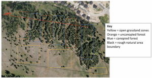
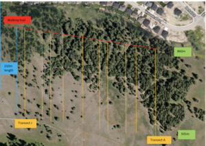
User: | Open Learning Faculty Member:
I used a distance-based random sampling method to gather information about the species diversity along the gradient of my research area. I chose a point in roughly the center of each sub-site to measure from, just to make sure I didn’t wander too far out of the research area and skew my data. I set the random number generator on my phone to have a maximum of 4, then chose two cardinal directions. (1 = N, 2 = E, 3 = W, 4= S). I then set the number generator to have a maximum of 25 and walked the generated number of steps in both random directions, then recorded my data on the closest tree and marked it with a ribbon. I experienced difficulties collecting data in the second sub-site because the terrain was so uneven and the vegetation that grew around the rocky outcrop in sub-site 3 was very thick. The data was not very surprising, as I’ve spent most of my life walking through the forest of my research area and have become familiar with the species that grow there and their spatial patterns. The random distance-based sampling technique I used was easy to implement and I will continue using it to collect further data. By using a random number generator on my phone and beginning from a predetermined center point, the abundance of each species of tree was easy to categorize and record in my field journal as I marked each tree that I had already sampled with a ribbon, as to avoid double-counting.