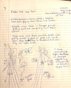
Blog Post 1: Observations

Date: 19-07-21

Time: 5:50-9:17 pm

Location: Iona Beach Regional Park, Richmond, B.C., Canada

Coordinates: 49.2168° N, 123.2049° W

Weather Conditions: 26 degrees Celsius; sunny and clear, occasional cloud; light breeze (SE 17 km/h); relative humidity of about 42%

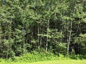
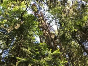
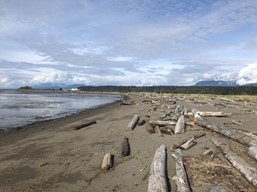
Topography: coastal sand ecosystem on a peninsula located about 5 km north of YVR international airport and 10 km southeast of the University of British Columbia campus.

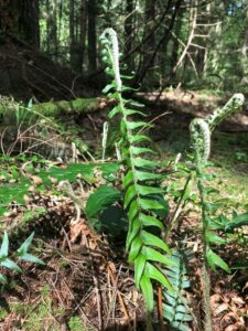
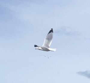
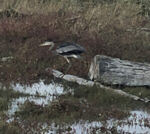
Species: Large-headed Sedge (Carex macrocephala); Dune wildrye (Leymus mollis); Blue heron (Ardea herodias); Bald eagle (Haliaeetus leucocephalus); common sea gull (Larus canus)

Observations: Upon arrival, the tide had already begun receding from the high of 3.12 m at 2:14 pm towards the low of 1.09 m at 8:29 pm. The beach is composed of sand flats with sparse vegetation and shrubbery, slowly descending into where the Fraser river runoff meets the Pacific ocean (estuary). Iona beach is also located along the Pacific Flyway, thus the diversity of bird species visible here year round is incredible. Many large-headed sedges everywhere. Lots of tracks appearing to be from dogs observed in the sand—possibly coyotes too? Many layers to the vegetation including sand, small vegetation such as sedges and dune wildrye, shrubs, washed up and decomposing drift wood.

common sea gull, Larus canus.
Blue heron, Ardea Herodias.
Large-headed Sedge, Carex macrocephala.
Sand flats of Iona beach, sloping into the estuary where the Fraser river meets the Pacific ocean.

Important Reminders: Bring binoculars next time to observe bird species more closely, and a ruler or tape measure to measure vegetation and animal tracks. Wear close-toed shoes—sedges hurt!

Being interested in the ecology and conservation of both the plant and animal life at this lovely beach, I believe this location would perfectly suit my field project for this course. As I continue to visit, I will take more detailed observations and measurements of the surrounding vegetation to understand how the gradient changes from the upper shrubbery and dune wildrye to the lower algae and estuary species found nearer the water. I look forward to working on this project and gaining a deeper knowledge of the natural history and ecology of this beach.

Blog Post#1 Observations (Robyn Reudink)

May 29, 2021 at 5:55 PM

The area that I selected is a city park that is not so far from my place, called Floden Park Loop Trail ,situated at 4209 111 Avenue NW, Edmonton,  Alberta. Its approximate size is around 1.2 km and 23 m elevation. It is a loop trail park with lots of vegetation, river (water body), forested frees, bird, walking trail and small animals. I visited this park at 5:55PM on May 29, 2021 and the weather was nice, sunny and warm and little windy, 18-20 degrees.

The potential subjects I want to study based on my observations are following:

I observed the profusion of small animals such as squirrels, rabbits and birds, for example, a medium sized black bird, (probably black billed magpie), crows, geese and small sparrows (maybe Boreal Chickadee). I noticed all these around the trees and on the ground near water, feeding on grass, earthworms, flowers (dandelions, sunflower, etc.), seeds, fruits, other small insects, mushrooms near river (beside vegetation near water body) and some on the trees, on fallen tree logs and some around the roots of the trees. Some of the birds were fighting and competing for food. They might have nests in those trees or laid eggs there. I was questioning why dandelions are found everywhere on the ground as I have seen them almost everywhere even in the school parks near me. I was also thinking about the diversity and abundance of mushrooms as they were noticed and are there any poisonous mushrooms in the city. I saw bracket fungi, Jelly fungi and coral fungi. I also saw small holes digged in the park, illustrating presence of rabbits and squirrels. There were many dogs too with their owners (some running after birds). I am interested in researching about birds (especially geese, terns, seagulls and black billed magpie), mushrooms and trees. The grass and trees are fully grown. The questions includes:

  • What do these birds usually eat for the survival of themselves and their young ones and how many hardships and challenges they have to face during it?
  • What migratory birds are seen often here in this area and how are they adapted to the weather, food and other conditions to the place where they migrate and is there any competition or predation that they face within the species or from diverse bird species? How do they cope with it? Does the location makes any impact on their number, biomass and density?
  • What kind of tree species are found here the most, any principal species and how are they beneficial to other organisms and is there any mutualism or commensalism found in the ecological community where they are located?
  • What factors help in sustaining the abundance and diversity of fungus and mushrooms in the biological area? What are the different types of mushrooms?
  • Evaluate on the distribution of density dependence among birds, insects or smaller mammals?


Read More

Post 1: Observations

Date: 14/05/2021


Time:  4:30 PM


Weather: 26 °C, Sunny, Humidity: 34%, Wind: 14km/h


Location: King’s Park in Winnipeg, Manitoba.


Topography: beside the bank of the Red River Lake


Vegetation: Forest + grassland


Observations:

The site that I chose to conduct my research in is King’s Park Winnipeg, Manitoba. It is a park and residential subdivision located on the Western side of the Red River bank. The park includes walking trails, an off-leash dog park area and marshland and some ponds creating edge habitats.  The space is about 592 x 270 m.


As I entered the park, the first tree species that caught my eye was White Spruce trees. Following the trail, I noticed the most abundant tree species to be Jack Pine trees. As I walked around the park, I noticed some ponds some of which were dried up next to the off-leash dog area. There are many different species of shrubs that can be seen near the forested area by the lake. Some of the shrubs that I identified are the Virginia Creeper (Parthenocissus quinquefolia), Common moonseed (Menispermum canadense), Poison Ivy, Garden Rhubarb, Common lilac, and Mercurialis perennis. Other species that can also be found at King’s Park are the Red-winged black bird, ground squirrels, and monarch butterflies. As I was walking through the forested area, I noticed a high abundance of different types of worms hanging from strings. Some of these worms were also seen on the ground since their strings might have been cut off due to human disturbances.


Questions:


  • Which shrub species dominate the area and what are the reasons behind it?
  • What are the anthropogenic effects on the lifecycle of worms?
  • Do the tree species composition change from the entryway of the park towards the forested area near the river?


blogpost1 

Blog Post 1: Observations

I have selected to observe the Serengeti ecological area through the use of the Zooniverse project, a platform for “people powered research”. The landscape of Serengeti National Park varies from woodlands to savannah to grasslands. Also, the climate ranges from warm and dry with a rainy period from March to May.

Further, this resource utilizes camera trap images and has been used in various publications. I will be utilizing the Snapshot Serengetti project to form a hypothesis focusing on the feeding behaviours of organisms.

Questions,

  1. Which organisms feed in groups (>2 individuals) and which graze individually?
  2. Does the presence of other animals from different species have an effect on whether or not an organism graze indvidually?
  3. Are there patterns that are species-specific?


Blog Post 1: Observations

The location that I have selected for study is a forested section of land immediately next to my house. It is a section of Crown land located between the highway and a side road in the Cariboo region.

It is approximately 0.2ha of rolling topography which has depressional areas. I have visited this site recently during the months of May and June, under varying weather conditions of rain and sunshine during the spring months. Today it is about 20 degrees with sunshine.

There are many subjects for potential study using this location. I have the following questions which could form the subject of a research study:

  1. How does canopy closure or lack of canopy closure influence species biodiversity in the area?
  2. Is this area being used by large mammals? If not, are there ways to encourage its use?
  3. Are there invasive plants at the site? How are they affecting the biodiversity and health of the site?
  4. How does the biodiversity differ between a site which is located close to our well and one located farther away?

Images:

Overview of the Forested Lot
Dead Standing Timber in Lot
Interior of the Forested Lot showing Canopy Gaps
Characteristic Understorey Vegetation


Untitled

The chosen study area is in my backyard (private property) in the residential neighborhood of Aberdeen in Kamloops, B.C. The surrounding vegetation is ornamental and the topography is rolling hills. My last site visit was on May 23rd 2021 at 11:00am and the weather was sunny (26°C) with no precipitation.

My proposed study is to conduct an experiment that measures the growth rate of sunflower plants based on 2 different watering volume applications (i.e. 2 study groups). The study would be conducted over a 6-week timeframe during the spring/ summer of 2021. This would involve growing potted sunflower plants, side by side, in an area that is approximately 20 m2. Half of the potted sunflowers would receive a consistently higher volume of water applications than the other study group, which would receive a lower volume of water throughout the experiment. There would be a total of 24 sunflower plants used in the experiment. There would be 12 sunflower replicates – in each study group – which would all receive the same watering volume applications. The corresponding plant growth rate would be measured for both study groups. All of the other design variables would be constant (controlled), including the – location, sunlight, growth medium, climatic conditions, and watering application time intervals.

Other potential study subjects include setting up a similar study, as the aforementioned, except with using a different predictor variable, such as:

  • Measuring potted sunflower plant growth rates at 2 different locations (in my backyard) that have different sunlight exposure levels, including – a full shade and a full sun exposure location.
  • Measuring sunflower plant growth rates by comparing the use of fertilizer to unfertilized plants.

Potential study questions, include:

  • Is the sunflower plant growth greater in the high-water volume application study group?
  • Is the sunflower plant growth greater in the full sunlight exposure study group?
  • Is the sunflower plant growth greater in the fertilizer study group?
  • blog 1 photos

Post 1: Observations

I have selected an area of Esquimalt Lagoon located in Victoria on Vancouver Island, B.C. The area of interest is beside the ocean and in a little nook with a wetlands area some rocky shoreline and a grassy patch that is close to the road. There is fresh water run off from a drain that leads to the ocean shore. There is abundance of plant species including Oregon Grape and lots of tall grasses. The location was visited at noon on a sunny spring day in May and is approximately 50 ft by 40 ft. The spot I am interested in is full of birds of various species which makes sense since the lagoon is considered a bird sanctuary and I believe the birds would be great potential subjects. Three questions that could be formed are; What are the different bird species found to be eating and why?, Which is the proportion of strictly migrant birds vs strictly native ones in the area and suppose why?, Which birds more frequently stay in the area at different times of the day and suppose why?

Blog Post 1

Date of Site Reconnaissance: 2 May 2021
Weather: Partly Cloudy, no precipitation
Temperature: 14 degrees Celsius
Season: Late Spring

A site reconnaissance was completed at the proposed study area which is located immediately west of Ladysmith, BC (Figure 1) on 2 May 2021 from 1345 to 1423.  The area is approximately 0.36 km2, with an elevation range of 115 m to 190 m above sea level (asl), with an average elevation of 145 m asl. The study area overlaps with municipal land and provincial crown land and falls within the Coastal Hemlock very dry maritime (CWHxm) biogeoclimatic zone (Government of BC 2021). The study area is comprised of two general habitat types: second growth coniferous forest and open, tall-shrub habitat. It is bounded to the west by Holland Creek and the Ladysmith water filtration facility, to the north by a rocky ridge, and to the south and east by additional clear-cuts (Figure 2). The study area was derived this way so the two available general habitat types were approximately equal in size.

Figure 1: General Location of Study Area

Figure 2: Study Area

The second growth coniferous forest is dominated by coast Douglas-fir (Pseudotsuga menziesii var. menziesii), with western hemlock (Tsuga heterophylla) and western redcedar (Thuja plicata) being the sub-dominant tree species. The understory is dominated by salal (Gaultheria shallon), with lesser amounts of vine maple (Acer circinatum), oceanspray (Holodiscus discolor var. discolor), and red alder (Alnus rubra) (Photograph 1). The forest is somewhat sloping, with a steeper gradient to the west. This area has a canopy closure of approximately 60 % and a moderate amount of coarse woody debris. The following bird species were recorded in this habitat type during the site reconnaissance:

  • Townsend’s warbler (Setophaga townsendii)
  • Pacific-slope flycatcher (Empidonax difficilis)
  • Pine siskin (Spinus pinus)
  • House finch (Haemorhous mexicanus)
  • Orange-crowned warbler (Leiothlypis celata)
  • American robin (Turdus migratorus)
  • Brown creeper (Certhia americana)
  • Red-breasted nuthatch (Sitta canadensis)

Photograph 1: Example of second-growth coniferous forest portion of study area.

The open tall-shrub habitat falls within a right-of-way for a transmission line as well as an additional cleared space (Photograph 2). Vegetation is largely dominated by scotch broom (Cytisus scoparius), with lesser amounts of sapling vine maple and red alder, and some small patches of salal. A few mature bigleaf maple (Acer macrophyllum) are also present, but generally the area has no canopy closure. The area has minimal coarse woody debris and is generally flat. The following bird species were recorded in this habitat type during the site reconnaissance:

  • Spotted towhee (Pipilo maculatus)
  • Dark-eyed junco (Junco hyemalis)
  • Anna’s hummingbird (Calypte anna)
  • Rufous hummingbird (Selasphorus rufus)
  • American goldfinch (Spinus tristis)
  • American robin
  • Northern flicker (Colaptes auratus)
  • White-crowned sparrow (Zonatrichia leucophrys)
  • Song sparrow (Melospiza melodia)
  • Turkey vulture (Cathartes aura)

Photograph 2: Example of open, tall shrub habitat portion of study area.

Three questions that arose from the site reconnaissance are as follows:

  1. Which habitat type has a higher bird species richness?
  2. Which habitat type has a higher bird abundance?
  3. Do invasive vegetation species have a detrimental effect on local bird populations?


References

Government of BC. 2021. iMap Mapping Tool. [accessed 2 May 2021]. https://maps.gov.bc.ca/ess/hm/imap4m/

Blog Post 1 – Observations

Date/Time:

Visited the site on May 1, 2021, at 16:00.

Weather:

The weather was partly cloudy with no precipitation. The temperature recorded at the site was 17oC. The seasonality is Mid Spring.

Observation Area:

The area that I have chosen to observe is the forested portion of a City park in Coquitlam, BC called Mundy Park. This park is 1.39 km2, has two lakes, is flat and mostly forested.  The park is surrounded by dense suburb developments, and the park trails are a common area for dog walkers and runners.

Figure 1. Satellite View of Mundy Park

Observations:

While walking through the park I noticed that there were different plant species that appear to thrive near the lakes when compared to other regions of the park. My main focus was the abundance of plant species near Mundy lake which is more centrally located in the park and more accessible. The forest seems healthy with few invasive species identified in the central areas of the park. Some of the plant species that I was able to identify are shown in the figures below.

lakeside loop trail
Figure 2. Lakeside Loop Trail
Western trillium
Figure 3. Western trillium
Salal
Figure 4. Salal Near The Lake
Oval-leaf Blueberry
Figure 5. Oval-leaf Blueberry
Western sword fern
Figure 6. Western Sword Fern

Questions

  1. Which areas of the park have the greatest number of Oval-leaf Blueberry and what are the reasons? (sunlight?)
  2. Does proximity to Mundy Lake correlate with a change in the plant species that exist in the area?
  3. Does the proximity to the homes and roads surrounding the park result in a higher number of invasive plant species? (Does the perimeter of the park has more invasive species?)

Blog Post #1 – Dufferin Wetlands

Apr 26 Field Journal

Date/Time: 2021-04-26 at 17:30 hours

Weather: 16oC, partly cloudy

Seasonality: Mid-spring season.

Location: Dufferin Park Wetlands – 1840 Hillside Drive, Kamloops, BC

Designation: City Park


General Description:

Dufferin Park Wetlands is a flat area that is approximately 1900m2. The area was converted into a wetland and designated as a city park in late 2017, and has seen a great deal of development since its creation.

Topography: Dufferin Park Wetlands is located at the base of several hiking trails in the Kenna Cartwright provincial park. Essentially speaking, it is a flat area that is nestled in at the base of a mountain slope. The wetland also bordered by an elementary school, a paved city street, and a set of tennis courts with an attached parking lot.

Vegetation:

The vegetation in this area is primarily comprised of riparian and aquatic wetland type vegetation that transitions into upland vegetation. There are many species of both riparian and aquatic vegetation, which I anticipate to explore in the future.

Observation Questions:

  • Is there a relationship between temperature and species richness/prevalence in this wetland?


    1.  
  • There are many non-aquatic bird species present in the area that appear to be actively competing for territory. What does this type of vegetation offer for these bird species?


    1.  
  • This park is nestled in between a school, tennis courts, a city street, and some provincial park hiking trails. In what ways might these anthropological factors affect this wetland area?