Post 1: Observations

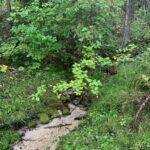
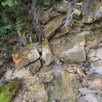
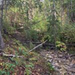
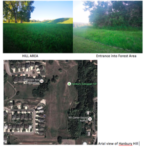
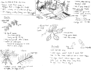
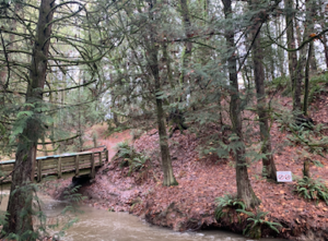
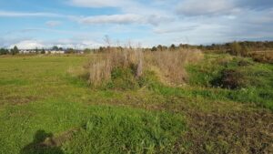
The site I have selected for my project is a ravine in the Yorkson Creek Trail of McClughan Park in Langley, B.C., Canada. It is located behind an elementary school and there is a bridge that crosses over the creek. It is quite a popular trail for people to take their dogs on walks. I visited the ravine on Friday November 13, 2020 at about 14:10-14:45 hours. It was a cloudy day with a temperature of 8°C. There was heavy rain in the morning so the ground was quite muddy and slippery. There is a steep slope heading down towards the creek and bridge. It is a heavily forested area with lots of pine trees and also at this time of year, bare trees whose leaves are scattered throughout the forest floor. The creek water was muggy and running quite fast. 

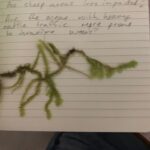
The area is home to many birds, animals, and fish, but I was not able to spot any during my visit. I decided to focus my observations on vegetation. The first plant that stood out to me was at the entrance of the trail, at the top of the ravine. They were some plants with white balls at the ends. I thought it must be some type of fruit in its early stages. Upon further research, I found they were snowberry plants. They were not covered by any trees and interestingly, I only found these plants at the top. This leads me to believe that snowberries need direct sunlight in order to grow. Ferns also caught my eye. They seemed to be scattered randomly throughout the entire area, but after taking a deeper look, I noticed they seemed more abundant around tree trunks and also further away from the creek. The last plant I observed had a thick, thorned stem with large green leaves. It seemed like they grew only near the water, as I did not spot them anywhere else. 

The three questions that came to mind during my visit were:

  1. Do snowberries need direct sunlight or are they able to grow under shade as well?
  2. Do ferns grow primarily under shade? Do they grow in moist environments, but not too close to water? 
  3. Do the large green plants require lots of water to grow?

I would love to study the snowberries, but I think I would like to conduct my research along the elevation gradient of the slope and because the snowberries were only located at the top, they may not be a great topic for my project. Instead, the ferns seem more feasible, so I will focus my observations on the ferns on my next visit. 

Scan of field journal
View of creek and slope from the bridge


Blog Post 1: Observations

The area I have selected to observe is the Woodhaven Nature Conservancy Regional Park.  The park is 29.8 hectares and is located in the Lower Mission area of Kelowna, British Columbia (Parks Services, n.d.).  The park is comprised of woodland areas, riparian areas, and steep slopes.  The park has two small creeks running through it, Bonaparte Creek and North Fork Creek, as well as the larger Bellevue Creek is located on the south perimeter of the park (Figure 1).  The park is designated as a regional park.

An interesting aspect of Woodhaven Park is there are four distinct bio geoclimatic zones which are considered sensitive habitats that are threatened and endangered in the region: a black cottonwood zone, a Douglas-fir zone, a ponderosa pine zone, and a western red cedar zone (Figure 2) (Parks Services, n.d.).  Black cottonwoods grow in damp riparian areas whereas Douglas-firs can grow in a wide variety of soils but prefer partial shade and soils that are well drained (Parks Services, n.d.).  The ponderosa pines are the only pine trees in the area and prefer dry conditions; they are located up the steep sandy hillside (Parks Services, n.d.).  The red cedars are able to block out sunlight resulting in less shrubs where the red cedars are growing (Parks Services, n.d.).

I visited Woodhaven Park on October 24, 2020 at 1:40pm.  It was overcast and there was approximately 15cm of precipitation in the form of wet snow within the previous 48 hours.  There was still snow on the ground and the ambient temperature was -1˚C.

The first aspect I think would be interesting to study is the different bio geoclimatic zones within the park and what is the cause for the different zones?  Upon my initial visit I saw the western red cedar trees and Douglas-firs (Figures 3 and 4), but still need to see the ponderosa pines and black cottonwoods.  My first question is what influences each of the bio geoclimatic zones within Woodhaven Park?

I read the information board at the entrance of Woodhaven Park and it provided information on wildlife trees which look like dead trees that have holes in them (Figure 5).  Although these dead trees can pose a hazard to the public, they are not all removed due to the habitat they provide to the screech owl (Parks Services, n.d.).  The screech owl, which is an endangered species, uses these wildlife trees for nesting and roosting (Parks Services, n.d.).  There are only 200 screech owls left in the Okanagan Valley (Parks Services, n.d.).  The screech owl and the wildlife trees they use as habitat would be an aspect of Woodhaven Park I would like to further study.  My second question is will I be able to see a screech owl during my visits and do other species use wildlife trees in addition to the screech owl?

Upon my visit I also saw three sets of tracks in the snow and wondered what type of animal made those (Figure 6).   They were all headed in the same direction, north.  I also saw two deer without antlers (Figure 7) and a grey/brown squirrel (Figure 8).  My last question is what are the different types of mammals that inhabit Woodhaven Park?

References

Parks Services. (n.d.). Woodhaven Nature Conservancy Regional Park. In Regional District of Central Okanagan. Retrieved from https://www.regionaldistrict.com/media/19817/woodhaven%20brochure.pdf

Post 1: Observations

I chose to study to area in Fish Creek that is approximately 3.5km from my home. The area is a stormwater pond that is surrounded by walking paths. This stormwater pond has signs posted that it frequently floods and to keep your distance as a safety precaution.
The main area that I am looking to study will be a region of increasing elevation to the north side of the stormwater pond.
The area consists of grassland areas which are higher elevations and riverine areas that run along the edges of creeks and ponds.

Observations:
I usually run from my house, up to Fish Creek, through a section of Fish Creek that passes by the stormwater pond, and then loop back towards my house.
The stormwater pond is completely surrounded by walking paths which provides an unnatural barrier for vegetation.
I have seen water levels rise and fall in the pond but have yet to see a drastic increase but there does seem to be a distinct line where vegetation density increases. This could be a high point of flood in and around the region.

Some of the vegetation that grows in the area are:
– Cow parsnip
– Asters
– Veiny meadow rue
– Karl Foerster
– Silver sage
– Cotoneaster
– Dogwood
– Aspen trees
– Poplar trees
– White spruce trees
The trees and larger shrubs were not present at all until at least 10 ft past the walking paths uphill except for a couple of spruce trees.
There seems to be a fair amount of human traffic in the area as I have yet to run through that section of the park without seeing other people. There are paths through the grass and brush in some area where people make their own paths or their dogs are left to roam. There was also some construction on the walking path that resulted in some vegetation and trees being removed. These larger trees and shrubs could provide a base for smaller vegetation to thrive in the immediate vicinity.

Post 1: Observations

Ecology refers to the scientific research of the relations that living organisms have with respect to each other and their natural environment. Fieldwork happened in the Acadia Research Forest (ARF) situated 20 kilometres northeast of Fredericton, New Brunswick, on Highway 10. This research forest was established in 1933 and continues to function as one of Canada’s essential and oldest research forest. The Acadia Research Forest is dedicated to facilitating continuing forest research or study through secure research sites. Additionally, the forest protects wildlife habitats and species that are at risk. I visited the Acadia Research Forest on 10th September and conducted field research at night and in the daytime. The potential subject that I want to explore for my research is Insect ecology and Natural history. Based on my observations, the interesting questions that may form the subject of the research project are:

  1. Why is it important to manage and conserve forest ecosystems?
  2. How are insects important in terrestrial biodiversity, particularly emphasizing on their excessive abundance and species richness?
  3. How to investigate the taxonomy and explore natural history and understand the functions or roles of the insects using observation methods in the field?

The identification of the insects and discovering their natural history as well as understanding their importance helps in creating awareness of the significance of the forest habitat conservation.

Blog Post 1: Observations

The area that I have selected to observe is the Garden City Land Teaching and Research Farm, currently leased by Kwantlen Polytechnic University (KPU) in Richmond BC. The land is primarily bog and open for citizens to walk. It also has 8 acres of farmland run by the Sustainable Agriculture Program of KPU. The specific location I chose is between the untamed bogland and the organically farmed production land. I have selected an area of large stretch of land on the southern side. This area is generally flat but has been specifically modified by the professors at KPU to do their ‘Greenhouse Gas Plot’ research project; this entailed digging down to the bog in segments and leaving other segments with the mineral soil layered top. There is a notable gradient between the two different plots. I visited October 19 at 16.00 during a cool and dry day, however the week prior saw heavy precipitation. I observed that there was a denser and more diverse group of plants closer to the peat.  I observed that the scentless chamomile was very abundant on the top soil and very scarce nearer the bottom of the pits, and that clover was prominent throughout but more abundant at the bottom of the pits.  overall, there was more abundance and diversity at the bottom of the pits.  I am not sure whether to focus on a specific plant or where there is more diversity.  Before I collect samples I will be mowing the site to simplify the observation of my sample group (TBD).

over time.

My three questions are:

Is there a correlation between the soil being disturbed and the success of new plants establishing?
Are the plants that are lower more successful due to the shade in the lower level? Or more water access?
Does the pH of the soil being closer to the peat land provide a more suitable environment for the success and diversity of plants?

This is the farmland. The pits are along the right side of the photo.


One of the pits. This picture shows the difference in scentless chamomile abundance at the top and bottom of the pit.

Post 1: Observations

The study site I have selected is a creek formed by lake overflow down a cliff face into a valley surrounded by wetlands. It is called Peterson Creek and is a recreational green space with many groomed walking paths that are frequented by residents and often off leash dogs. Notable wildlife in the area was sparse, with minimal to no tracks visible, near silent trees with only one high pitched chirp coming from a small bird in the brush and a single brown squirrel in a decaying tree stump. The valley has a steep grade slope upwards that dramatically changes the terrain from lush, well-established greenery, to grasslands and eventually desert approximately 50 meters in elevation from the base.

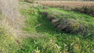
The area I have selected to study is 2 acres total radiating out from the creek bed and up both sides of the valley. The creek bed is mostly a rock base with sediment at the base of the waterfalls but it does not continue down the creek. The edges of the creek are quite steep as spring flooding erodes a deep scar that it left nearly empty by this time of year. Immediately surrounding the creek is grass, bamboo, and medium sized shrubbery with many types of berries visible. Scattered amongst this is a variety of medium and large trees of varying types.

A few I was able to form an educated guess towards their type were Pine, Birch, willow, maple and poplar. The area is located in the city center directly next to the hospital. It is surrounded by busy streets on each side that are not visible from the trails or audible due to the deep valley and brush positioning in relation to the trails. I made my first observation at the site at 13:00hrs, the temperature was 11 degrees C with a gentle breeze. The skies were completely cloud covered. 

I made many interesting observations during my first trip to the site; the most prominent in my mind were as follows. Does the lack of sediment and the narrowness of the creek bed along with the seasonable variability in water levels affect spawning of fish in the area? I also noticed a randomness to tree type and placement and was curious if these were planted intentionally to add appeal to the area and if so, does this adding of biodiversity in the area create more interest for animal population, or does it drive them away due to creating an abnormal habitat for them? Lastly,  I noticed a lack of debris in the creek. There were no sticks or blockages in the water, which struck me as an unexpected finding as a lake is what feeds the creek via a waterfall. Does the potential cleaning out of the creek for aesthetic purposes contribute to the lack of animal inhabitants?

Blog Post 1: Observations.

The area that I have selected to observe is the University of Manitoba South Wood lands, which was a former 120 acre  golf course next to the Red river. I was at the area on Sept 17th, Thursday from 4:10 pm to 5:00 pm. The temperature was 13°C which is the average fall temperature in Winnipeg around this time of year. It was quite sunny and not very windy. The vegetation is mostly grasslands, with tall and short grasses, pine trees along with the other local tree species which could be cottonwood and Elm wood long the riverbanks. There are two ponds on the golf course which are hot spots for the geese in the location, Winnipeg has urban geese which are present throughout the spring, summer and fall. The migratory geese (Branta canadensis and Branta hutchinsii) arrive in the fall around this time which  is why there are so many geese present in the grassland and around the ponds. Along with the geese there were so many white tailed deer feeding on the grass and weeds-dandelions.


Image 1: Map of the South Wood lands.  

Image 2 & 3: Journal pages.


There were a lot of birds chirping, I heard at least 4 different kinds of birds. One kind were shrikes based on the appearance and sparrows and jays based on the appearance as well. There  were trails along the river, few people were taking a walk. There were dragonflies and burrows in the ground around the ponds, showing that there might be rabbits and moles in the grassland. There was a lot of cricket noises along the river and there were few geese swimming on the river as well. More than 5 squirrels were spotted, there were a lot of pine nuts on the floor near the pine trees which the squirrels seemed to be collecting.

Image 4 & 5: open grass land and trails.


Based on my observations the three questions I asked are:

  1. How has the geese population affected the role of the other wildlife in this grassland area?
  2. How does the human activity around the south wood lands affect the deer and geese activity in the open grassland and riverbank area?
  3. How much resources are available for the urban geese when the migratory geese arrive in the fall? And also how the weather plays a role in how much deer activity is noted?

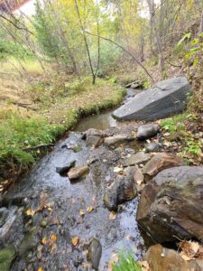
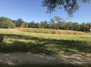
  Image 6: Deer feeding on the vegetation.

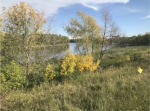
Image 7: The Red River.

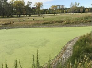
Image 8: Geese around pond 1.

Observations 1

07/09/2020

08:47

8 °C overcast

-transition season with summer ending and moving into fall, rainfall in the past 24hours


The site is located on Steamboat Mountain and is designated as rangeland, specifically the Bryanton Creek and Tea Kettle ranges.  It is a mountain slope with primarily conifer forests. I chose three small perennial streams that flow through the area (Figure 1). Each of the sites shows recent use by cattle (Bos Taurus) with tracks and manure.  The slope to access the creeks at the point of observation is varied for each location; site 1 location 4 is forested and has little slope (Figure 2), site 2 location 2 is steep, rocky and has small areas of pooling (Figure 3), site 3 location 3 is gently slopped with steeper sides (Figure 4). The streams are rocky and varying sizes of pooling with gravel to muddy linings.  All three sites have similar vegetation with large spruce (Picea ?), birch (Betula papyrifera),and Douglas fir (Pseudotsuga menziesii var. glauca) forming the primary canopy.  There is an abundance of red-oiser dogwood (Cornus stolonifera C. sericea), common horsetail (Equisetum arvense), and bunch berry (Cornus canadensis) as well as mosses and lichens at all three sites.

Figure 1 Creek locations created on iMapBC
Figure 2 Creek site 1
Figure 3 Creek site 2
Figure 4 Creek site 3
Field notes

Questions that I had after observing these sites includes:


Is the health of the streams impacted by the cattle?

Is there concern with E. coli in the streams with the cattle defecating in the streams?

Does the access to the stream, as far as steepness, have an impact on how used the stream is by larger animals such as cattle and ungulates?

Blog Post 1

I have chosen to observe a community Garden in the city. Below are my notes:


Designation: City Park, community garden

Field Journal 03-09-2020

Time: 1247 hours

Date: 03-09-2020

Weather: sunny, clear sky, hot and dry, minimal breeze, 21 degrees celsius

Seasonality: Summer, approaching fall

Study Area: Community Garden at 1645 East 8th Avenue Vancouver BC. Latitude: 49.2635 Longitude: -123.0711. Study area is generally small, approximately 2 houses worth of land (~1500 sq. feet)

Location: 2 bee hives located towards northern boarder of area, shed in north western corner and a park bench is located centrally on northern boarder. The Western boarder backs onto a large house, the Northern boarder is contained by a chain-link fence and you can hear the subway train in the distance. The Southern and Eastern boarder are marked by a street (Commercial Dr, and East 8th ave).  There are approximately 12 garden planters, and 2-4 pedestrians visited during my 20 minute stay. Many bees, flies, moths, butterflies observed. 1 bird seen.

Topography: grassy flat, likely human-made

Vegetation: grassland with ~12 large human-made wooden planters containing various vegetation, mostly edible plants (e.g kale, herbs, tomatoes, etc.) and flowers (unidentifiable)

Potential Subjects – Bees and other pollinators

Questions about this observation

  1. Which flowers or plants are most frequently visited and why
  2. Which time of day and during which weather conditions are honeybees most active
  3. Do honeybees prefer human planted vegetation or naturally growing vegetation to pollinate?

Blog Post 1: Observations

The area I have selected for my project is in the middle of the prairies in Brandon, Manitoba. The area’s location I have chosen has a few natural trails, a creek, and two distinct terrains with an immediate ecotone between the two. The first terrain is a forestry area with a gentl, slow flowing creek running down the middle, immediately adjacent to it is the second terrain a not-very steep hilly open grass field. Both these terrains are within an area classified as Hanbury Hill Park and are classified as a recreational-protected area. The Park is about 200 meters from a residential road.

My first visit to this location for observational purposes in regards to designing a study question:

  • Date: July 10th, 2020
  • Time: 5:30pm – 7:30pm
  • Altitude:
  • Temperature: 25C
  • Weather: Sunny, Clear skies, few clouds, slightly windy.
  • Seasonality: Summer

The size of area of interest:

  •             Hilly Grass Area: 20 yards
  •             Forest & Creek: 5 yards
  • Total area that will be studied: 25 yards

Observations:

Topography- Hilly Grass Area:

In terms of vegetation, the hill area has long grass species (~82 cm in height) with little variation, and is cut by the city once every month. There are a few trees very far apart from each other. The slope of the hill is not very steep ~20-degree angle at most on certain elevations. At the bottom of the hill is an outdoor Olympic sized track with few people running on it.

Species Observed:

  • Very few species of grasses
  • Gophers (& gopher holes)
  • Birds: crows and little sparrows
  • Deer
  • Grasshoppers
  • Ants
  • Occasional human walking or running past

There are a few biking trails pass through this area into the forest & creek terrain.

Topography – Forest & Creek Area:

This area is covered in numerous trees densely grown. Heavily shaded undergrowth due to the lush canopy of leaves provided from the trees. Trees and grass/shrubs in undergrowth are fully green and in bloom. The little creek has clear water slowly, and trickles down the creek that has rocks as its base.

Species Observed:

  • Very few species of trees
  • Deer
  • Some type of birds
  • Frogs
  • Humans (if you count myself and my lab assistant)
AREA OF OBSERVATION

Main Questions:

  1. What kind of species of gophers reside in the hilly area, and why are they not found in the Forest & Creek area?
  2. Is there more Deer activity in the hilly open grass area than the dense forest?
  3. Have the trails created by bikes influences how the animals and terrain interact with each other?