Blog Post 1: Observations

I have chosen a much larger area for my research project; The Bow Valley Area in Alberta, Canada. The area of focus will be, Peter Lougheed Provincial Park.  The area of study will encompass 304 square kilometres; totaling all three provincial parks .  As covid has encouraged more people to get outside and utilize our wild areas, this has caused an influx in human activity in and around our provincial parks.

I first visited the sites to gain initial observations on  August 20th, 2020 at 08:30hrs. The weather was favorable, 10° with winds  averaging 8km /hr to the sw with no precipitation.

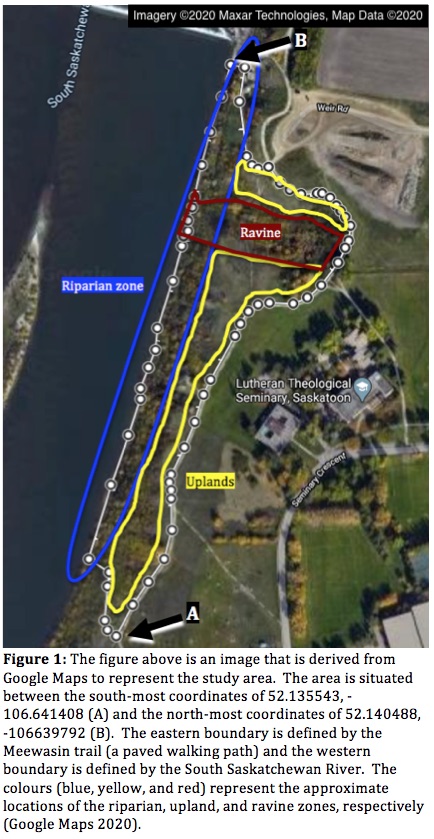
The park is home to an abundance of terrestrial wildlife and rich in native flora and hosts an abundance of Buffaloberry (Sheperdia canadensis)  which is a major food source for the Alberta grizzly bear (Ursus arctos ) population as they enter a state of  hyperphagia. The geography of the study area consist of rolling hills and mountains, with (2) rivers flowing though it, Kananaskis and the Bow River. There are recreational day use areas that surround large water bodies; numerous lakes are found in the park boundary. (Figure 1)
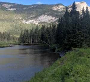
.  (Figure 1.)  Peter Lougheed Provincial Park

Listed as a threatened species under Alberta Wildlife Act, this time of year is crucial for foraging for food consumption for the bears.

Of all sites visited within the study area, it was observed that buffaloberry is abundant as a natural attractant alongside active hiking trails and roads withing the study area.  August is a prime time for foraging as the berries are ripe and in abundance.


The general observations in all the park was :

  • An abundance of buffaloberry bushes (Figure 2)
  • At least (1) bear was observed foraging within 5km of a Day Use Area (Figure 3)
  • Most Day Use Areas and trails were packed with people who recreated ,in particular groups of 3 or more people

The questions I asked and sought answers to are:

  1. During foraging season, does the increase of human activity in the park have a direct correlation with how the bears feed?
  2. Does this increase negative human/ bear  interactions?
  3. Does this deter sows with cubs from accessing abundant food sources near road ways and popular Day Use Areas and trails?

Buffaloberry
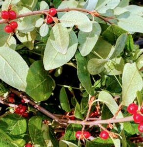
(Figure 1) Buffaloberry , 2020


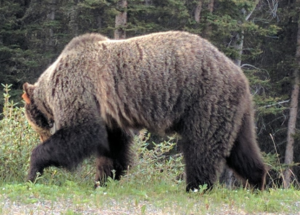
(Figure 3) Grizzly Bear 159 feeding on buffaloberry in Peter Lougheed Provincial Park, 2020


Evidently, should the data show negative responses to the questions above it can be assumed that this will play a role in the success of hibernation for the bears as well, they can develop a high tolerance to human presence. This may impact, negatively the success of the population if the female does not attain sufficient body fat or weight during the summer and fall as the embryos will not attach to the uterine wall. Ultimately I will focus on the negative human/bear encounters to determine if the more people that access the park causes an increase in these types of encounters during foraging season.

Blog Post 1: Observations of Campbell Valley Regional Park

I visited my site on August 13, 2016

Time: 13:33-13:55

Weather condition: Sunny with clouds and slight breeze.

Location: Campbell Valley Regional Park, South Entrance, located in South Langley British Columbia. The location of Campbell Valley Park was clear cut in the early 20th century and the temperate rainforest has regrown. My study location is the Old Orchard area that is an open field surrounded by forest. There are many different tree species: Maples Acer psedoplantanus, Aspens Populus tremuloides, Cypress Cupressaceae, Birches Genus Betula to name a few. There are also vine maples Acer circinatum, invasive Himalayan Blackberry.

Questions:

  1. What is the abundance of tree species around the field.
  2. What is the abundance of plant species in the north section of the forest.
  3. Why is there a pure stand of Aspens on the west side of the field vs a mixed stand north and east?

Facing West

Facing East
Field site facing north.

Blog Post 1: Observations

The area I have chosen is on private land in a rural farm community outside of Taylor, British Columbia. It is approximately 12 acres in total with a predominately coniferous forest with a ravine that holds a small creek and both sides of the creek are farmed fields. The ravine itself boasts a lot of  value with many different features such as small wetlands due to beaver (Castor canadensis) activity, pooling water and the running creek itself. It is important to note the creek is a lot more bank full than normal due to the increased amount of precipitation.

Figure 1. Area in yellow is the perimeter of the observation site. Red line that was walked within the area.

I first visited this area on July 14th, 2020 at 1400 hrs until approximately 1600 hrs. The weather was 20 degrees celsius with some overcast but, it was incredibly muggy. I remained in the area that is highlighted in yellow and scouted around within that perimeter that can be represented in the red line. The size of the chosen observation area is approximately  0.31 square kilometres.

The vegetation from the bottom of the ravine consisted of typical wetter vegetation species such as:

  • Lady fern (Athyrium filix-femina)
  • Meadow Horsetail (Equisetum pratense)

And then carrying up the slope gradient the vegetation has noticeable changes leading into species such as

  • Prickly Wild Rose (Rose acicularis)
  • Cows Parsnip (Heracleum maculatum)
  • A few willow species (Salix spp)
  • Saskatoon (Amelanchier alnofolia) 
  • Soopolallie (Shepherdia canadensis) 

Leaving the ravine and going into the field there are a good mix such as

  • Foxtail Barley (Hordeum jubatum)
  • Timothy (Phleum prantense) 
  • Kentucky Bluegrass (Poa prantensis)
  • Northern Brome (Bromus inermis)
  • Alsike Clover (Trifolium hybridum)
  • Alfalfa (Medicago sativa) 

This crop farmed field is mostly Alfalfa with the other species making random appearances throughout the field. It would be good to do a proper walk though out the field as well.

Figure 2. View of the field that is hayed yearly.

There was also noted to be Black bear activity (Ursus americanus) due to several ant hills being dug up and some old marking in trees as well as tracks.

Figure 3. Black bear tracks located on the south side of the ravine.

There is also a lot of ungulate activity in terms of tracks and droppings. Mostly White tailed deer (Odocoileus virginianus) and Moose (Alces alces). Elk (Cervus canadensis) are also known to frequent the area but, determining the difference in tracks is a little tricky. 

Potential subjects and relevant questions

Question 1: Do the species of ungulates that frequent the upper field selectively graze? (I feel this is where I will go with my study)

Question 2: Despite being older and potentially no longer in use, how much is the old beaver dam impacting the area of the lower ravine?

Question 3: Is this relatively small area able to support a Black bear for a suitable territory or is it a series of areas frequented?


Post 1: Observations

Site description:

The observation site (The Site) is located at King Street East and Bond Street on the Harmony Creek trail in Oshawa, Ontario. The site is located in an urbanized park with an engineered flood plain and built habitat. The site extends approximately 40 – 50 metres from the harmony creek (which runs north south along the west boundary of the site) on the west to the guard rail of Bond Street on the east. The site follows the creek for approximately 80 metres from a tunnel where Harmony creek passes below King Street in the south to a park bench at the north boundary.

The east creek bank is vegetated with trees, flowering plants and small shrubs. These plants, trees, and shrubs extend from the creek bank, approximately 5 metres to the Harmony Creek Trail – which is paved with asphalt. On the opposite side of the trail (east side), the flood plain is vegetated with manicured grass for approximately 15 – 20 metres. To the east of this grass is a slope that forms the upper boundary of the flood plain. This slope is vegetated with tall grasses, flowering plants and several mature trees.

Time: 4:15 pm. August 9, 2020. Mid-late summer.

Weather:

Partially cloudy. Winds 20 km SSW. 27 degrees Celsius.

Observations:

  • A construction site is set up to the south of the observation area. The path under King street is closed with fencing.
  • Crickets audible in the vegetation near the creek at the south end.
  • Grass is dry and brown to the east of the path.
  • House sparrow observed on the path. It is flying back and forth between from shrubs and the asphalt. Shrubs have grape vines in them.
  • Creek is running calm and clear. No fish observed. No odours or sheens observed. The construction team has installed some netting in the creek.
  • Grassy area on the slope to the east has Dog Strangling Vine growing on it. Vine looks de hydrated. Leaves are shriveled.
  • Monarch butterfly observed flying through the area. No milkweed observed during inspection.

Questions:

  1. What avian species frequent the area?
  2. Is the dog strangling vine spreading? The vines looked to be stressed. Are they producing seeds?
  3. The creek runs through an urbanized area with significant human impact, are any fish species present? Are there any species that run upstream to spawn in the fall at this location?

photos aug 9

Post 1: Observations

Blog Post 1

   The area I have selected for my field research project is an approximately 0.021204 km^2 stretch of land surrounding my house. Located in Springwater Ontario the area is flat and has a dense boreal forest that sustains a rich biodiversity of insects, small mammals, reptiles, and birds. The ganaraska trail runs through this area along with a few other man made hiking trails. There are very few houses nearby meaning that with the exception of the trails, there is little to no evidence of human activity. 

   There is a seasonal pond that is approximately 0.015 km^2 of still water which has now turned into a field of lady ferns. The area around the pond is flat which makes the ground damp and muddy. After thunderstorms, which are common during Ontario summers, the pond and surrounding area floods. 

My site
The trail
The pond turned to lady fern field

First Visit 

  • June 29th, 11:34,  28*C, sunny with some cloud coverage, humidity of 55%
  • 44.51604 N, 79.746865 W 
  • Springwater Ontario
  • Boreal forest


Wildlife:

  • Garter snake (Thamnophis sirtalis)
  • American robin (Turdus migratorius)
  • Eastern Wood-Pewee (Contopus virens)
  • Fowler’s Toad (Anaxyrus fowleri
  • Chipmunk (Tamis striatus)
  • Ruby Throated Hummingbird (Archilochus colubris)
  • American Goldfinch (Spinus tristis)
  • Spotted Salamander (Ambystoma maculatum)
  • Deer Mouse (Peromyscus maniculatus)


Vegetation:

  • Alternate-Leaf Dogwood (Cornus alternifolia)
  • Black Spruce (Picea mariana)
  • Eastern White Cedar (Thuja occidentalis)
  • Jack Pine (Pinus banksiana)
  • Sugar Maple (Acer saccharum)
  • Blue Beech (Carpinus caroliniana
  • Paper Birch (Betula papyrifera)
  • Orange Lily (Lilium bulbiferum)
  • Lady Fern (Athyrium filix-femina)


Notes:

  • The pond has optimal conditions for mosquitoes to breed
  • There are 2 new fallen trees after the most recent thunderstorm
  • The presence of the snakes has led to a noticeable decline in mice and toad populations around the house
  • Robins nest with 3 eggs approximately 3ft off the ground in an Emerald Green tree
  •  4 Garter snakes that live in our wood pile
  • Eastern Wood-Pewee nest with 4 hatchlings on the back deck
  • I lifted up a small log that was blocking the trail and underneath was a Spotted Salamander
  • Many Fowler’s toads on walk to the pond
Eastern Wood-Pewee hatchlings
Garter Snakes

Questions:

  1. How does the weather affect the snakes behaviour?
  2. How long does it take for the baby birds to leave the nest?
  3. Is the soil more fertile at the pond than it is around the house?

Blog Post 1: Observations

The area that I have selected for my field research project is the Erlton/Roxboro Natural Area in Calgary, AB (Figure 1). Located in the heart of Calgary, it is designated as a natural park. This designation specifies the importance of maintaining its natural flora and fauna by the city. This area, covering approximately 13,300m², comprises a hill leading to an upper ridge with an elevation change of about 27m.

Figure 1.

Roxboro & Erlton off-leash dog park flanks the base of the hill on the west side and there are two main walking trails. One trail leads up the side and across the upper ridge while the other meanders horizontally across the slope about 50% of the way up. Other nearby features include a children’s playground, tennis courts, a cemetery, the Elbow River and residential communities. As an important side note, the city of Calgary has posted a sign regarding upcoming herbicide application against dandelions and other broad leaf weeds.


I visited the area on 10/07/2020 in summer at 11:15 until 13:00. The weather was 22°C and mostly sunny. On the day I visited, the top of the ridge was bathed in sunlight while the lower half was shaded, primarily due to the canopy of larger trees (Figure 2).

Figure 2.

The forest floor at the bottom of the slope was marked by a labyrinth of fallen logs and grass (Figure 3).

Figure 3.

Further up the hill, the underbrush of the forest was more dense with greater varieties of grass and wildflowers (Figure 4).

Figure 4.

Just before the slope levels out at the top, the incline sharpens and reveals patches where the ground is more eroded (Figure 5).

Figure 5.

The top of the ridge is flat and riddled with wildflowers, grass, shrubs, and trees (Figure 6).

Figure 6.

Another noteworthy feature is a small spring at the midpoint of the slope that trickles down at the southern end.

On this day, I noted a lot of noise emanating from the surrounding streets, playground, dog park and local construction.

Birds were seen primarily throughout the more forested areas both on the ground and in the trees, sometimes feeding on garbage. Bees were seen among the wildflowers, and I also identified what I believe to be bobcat scat. Among the flora and fauna, several species were identifiable including:

Black-billed magpies (Pica hudsonia)

Northern flickers (Colaptes auratus)

Black knot (Apiosporina morbosa) (Figure 7)

Johnson grass (Sorghum halepense)

Siberian peashrub (Caragana arborescens) (Figure 8)

Canadian violet (Viola canadensis)

Figure 7.
Figure 8.


Questions:

  1. Does the amount of time birds spending foraging on the ground differ statistically across varying proximities to anthropogenic related noise?
  2. How significantly does the angle of the slope impact a tree’s seed dispersal radius?
  3. How significantly different is soil moisture retention between steeper vs. flatter sections, and/or sunnier vs. shadier areas? How might this impact biodiversity in those zones?

Blog Post #1: Observation

The study area I have chosen is Duggan Community Garden located in Edmonton, AB. Visited in the summer season on July 15, 2020. I was at the site from 12:12pm to 1:03pm. It was 14°C, windy, cloudy and sunny on and off.

Physical description of the area:

The garden is 51.7m2 in perimeter and 114m2 in area. It is flat, with 15 garden beds, each bed containing different species from the others. Some garden beds were monoculture, but most of them were polyculture. The garden is surrounded by a compost area, grassland with a variety of ornamental trees, a community playground, and street roads. The 5 most common species planted in the garden are the beans (Phaseolus vulgaris), tomatoes (Solanum lycopersicum), pumpkins (Cucurbita moschata) carrots (Daucus carota), and lettuce (lactuca sativa). Below are the figures that demonstrates more details of the garden area.

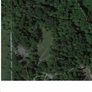
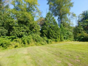
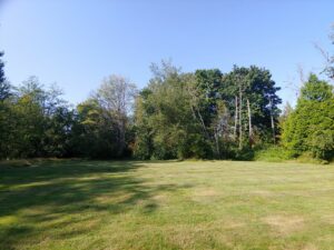
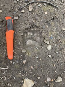
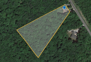
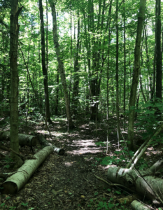
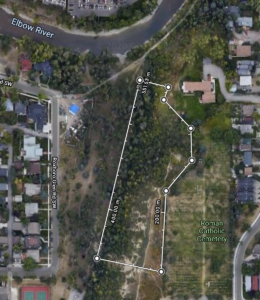
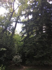
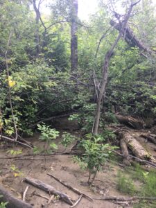
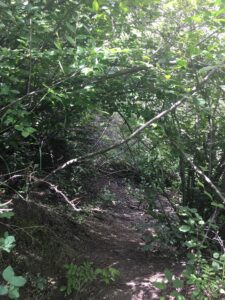
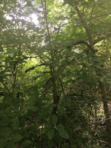
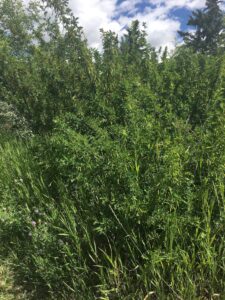
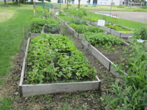
Figure1 : Overview of the study area, which is flat (Duggan Community Garden) with a variety of plant species.

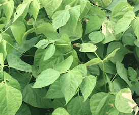
Figure2: Fresh green beans’ leaves with different colour consistency, some are turning yellowish, others becoming dry.

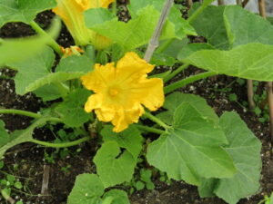
Figure3&4: Pumpkin plants flowering, on the right. However, as can be seen on the left some are starting to change colour, drying.

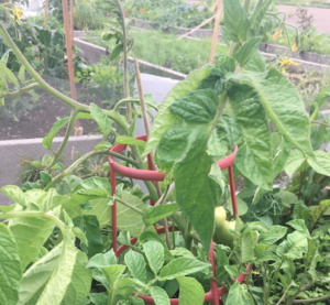
Figure5: Most grown tomatoes in pots, they are also flowering and bearing fruits.

Figure6: A Bee flying near the flowers.

As seen on the figures above some species have started flowering, especially the tomatoes and the pumpkins. With pumpkins showing relatively large flowers, with different consistency. Some are starting to develop, but others have matured. Unlike the pumpkins, the tomatoes have very small flowers.

The leaves of the plants are all green; however, there is uniformity especially in the beans and pumpkins’ leaves. In one particular garden bed the leaves were green, while in the other the leaves were turning yellowish. This made me ask a lot of questions. To what extent are the beans leaves’ colour affected by the abiotic factors in the surrounding environment? Could it be the different kinds of soil or compost used, could it be the days those beans were planted? These are questions I am looking forward to explore. Some leaves also had holes in them, could it be an indication of insect predators in the area? Could it be a result of the rain and hail that recently fell in this area? To what extent are the abiotic factors in the surrounding environment leading to leaves damage?

I also noticed a cluster of bugs in the area, as well as a few bees. I saw about 3 bees, and they would stick on the flowers for about 10 seconds, then fly away. They were more attracted to fly near the colourful flowers (see figure 6).

Finally, this garden had a number of evidences for human activity in the garden that would have an influence on the growth of plants in the garden. Some indication include the posters in the garden, the compost area, garden beds, and tomato pots.

Questions for a research project

  1. To what extent do the abiotic factors in the surrounding environment affect the change in colour of the beans leaves? and to what extent are the abiotic factors in the surrounding environment leading to leaves damage?
  2. How is the plant growth such as tomatoes affected by the pot?
  3. What are the main benefits of practicing monoculture and polyculture to the environment?

Blog Post #1

The area I have chosen to study is in Dawson Creek, BC. I am studying the forest and creek alongside the Dawson Creek walking trail. The creek winds through the walking trail and goes through the city park. My area of study starts near the Dawson Creek Public Library and continues through Kin Park. The Dawson Creek trail follows the creek for about 4.5 kilometres.


My first trip out was on 14/07/2020 at 9:50. It was about 20°C out and sunny. There was a little bit of wind. 

The main area of the creek I focused on was behind the public library. This area is in walking distance of my home, making it a convenient place for me to study.

The creek was low, despite the extreme flooding there was last week. The steeper areas of the creek bank are free of vegetation. All of the plant life on top of the slope is in full bloom.

Observations:

I observed a couple of beaver dams, which led me to wonder what time of the day I was most likely to spot a beaver. I also wondered if they were more likely to chew down certain trees rather than others.  I saw a few tree stumps that had chew marks in them. I also saw a bunch of mud by the creek that had been walked over, but I couldn’t make out any obvious footprints.


Next, I observed some flowers with bumble bees on them, which lead to me wondering whether or not they were more likely to pollinate certain flowers rather than others. I also noticed that the blooming flowers were pointing toward the creek and  I wondered whether or not there was a reason for this. Some flowers/planst I observed were:

  • Prickly Wild Rose (Rose acicularis)
  • Western Aster (Symphyotrichum ascendens)
  • Wild Lupin (Lupinus Perennis)
  • Cows Parsnip (Heracleum maculatum)

I observed some Cows Parsnip by the creek. They became more abundant as I got closer to the creek. I have heard that the sap inside of these can cause burns. The plants I saw and measured were around 58 inches tall.

I could hear lots of birds, but saw very few. Three birds that I saw were the:

  •  Black-billed magpie (Pica hudsonia)
  • Small Brown Bird (Unsure of species)
  • Crow (C. caurinus)

Due to my study area being near the public waking trail and park, there were many signs of human activity. There were plenty of human-made trails that went down to the creek.

Some potential study subjects for my project are:

  • Beavers (Caster canadensis)
  • Bumble bees (Bombus spp.)
  • Giant hogweed (Heracleum mantegazzianum)
  • Black-billed magpie (Pica hudsonia)

Three questions that could possibly help to form the subject of my research project are:

1. Do beavers have a preferred tree species? How is tree selection changed by availability and human activity? What effect do beavers have on the surrounding environment due to their activity? How does flooding effect them?

2. Which wildflowers are bees most likely to pollinate? Is there a specific species or colour that they are more attracted to?

3. Why is there fewer signs of vegetation near the water? It gets slightly less green as you go further down the slope. The giant hogweed, however, becomes more abundant as we near the creak. What is it that makes this species better suited to survive than every other species in the area?

Scan of my field journal:

Scan


Post 1: Observations

June 1st 2020

The chosen study area is a roughly 400-metre stretch of riparian zone along the western shore of Nita Lake in Whistler B.C. The shoreline varies between steep and gentle inclines from the waters edge up to the train tracks which run parallel approximately 20 metres from the shoreline. The shoreline topography varies between steep terrain with large semi exposed stone boulders that are patchily covered in thin (2-inch) layer of coarse fast drained topsoil, and lower lying areas with deep, spongy and moist soils covered by a thick layer of decaying detritus. The vegetation is a mix of red alder, western red cedars, western hemlocks, and the very occasional Sitka spruce. Red alder trees appear to be the most dominant species closest to the waters edge, and grasses and young red alders are the only vegetation found in the lowest lying areas.

Large trees, (over approximately 6 metres tall) appear only to on the higher ground, with the exception of some older red alders by the water’s edge. Over the other side of the railway there is extensive forest with western red cedars, western hemlocks and Douglas fir.

The lake became fully unfrozen in early April, and stream flow into the lake progressively increased, peaking in late May. The Lake water level rose approximately 40cm between early April and late may, and has since subsided by around 20 cm. At peak water level some areas of lower lying vegetation were submersed.
Weather: I visited the site at 4pm, and the weather was overcast, with a temperature of 12C.

Questions:
1. Are red alder the most dominant species in low lying, waterlogged and flood prone areas?
2. Are Western Red Cedars, Western hemlocks and Sitka spruce better suited to fast draining soils?
3. Young red alders (mostly less than 1 metre in height) appear to be abundant in the low lying areas. Are they a pioneer species after flood events?


Blog Post 1: Observations

The area that I have chosen to observe is a narrow stretch of civic land (approximately 38 576 m2 in size) located between the University of Saskatchewan and the eastern side of the South Saskatchewan River in Saskatoon Saskatchewan. The coordinates of the South-most point of the study area are 52.135543, -106.641408 and the coordinates of the North-most point are 52.140488, -106.639792. The site was first visited between 1515 and 1850 on June 7, 2020. During the visit, the weather was overcast with sporadic drizzle, high winds, and a temperature of 14OC. Observing the area revealed that there are three distinct areas (the riparian zone, the uplands, and the ravine) (Fig. 1, Fig. 2) divided by their elevation, vegetation, and vertebrate species. The uplands sit approximately 20 meters above the river surface and transition to a riparian zone over a steep bank. Furthermore, a ravine (serving as a swale for the University of Saskatchewan) resides in the northern region of the study area.

The riparian zone is extremely overgrown and contains many unmaintained footpaths that wind down towards the river (Fig. 3). The area exhibits a high level of species richness in vegetation including a high abundance of Vicia cracca (tufted vetch), Juniperus spp. (juniper), Gaultheria hispidula (creeping snowberry), and Vaccinium vitis-idaea (bog cranberry) making up the underbrush. Meanwhile, Pinus spp (pine), Picea spp. (spruce), Acer negundo (box elder maple), Ulmus americana (American elm), Amelanchier alnifolia (Saskatoon berry), and various Prunis species are the primary components of the canopy. Very few arthropods were observed (likely because of the high winds, cool temperature, and high precipitation throughout the week leading up to the visit of the site). However, scarring and galls (including Cynipid wasp galls) on leaves throughout the area indicated that there is an insect presence. In addition to vegetation and arthropods, Canadian geese, ducks, and various songbirds could be seen throughout the riparian zone.

The upland region of the study area is flanked, on the eastern side, by a paved walking path (the Meewasin Trail) that has several meters of grass cut around it. Beyond the cut grass is an area characterized by (mostly) low-lying wild flowers, grasses, and shrubs (Fig. 4). Aside from grasses, the dominant vegetation species appeared to be Saskatoon berry, Elaeagnus commutata (wolf willow), and Astragalus pectinatus (narrow-leaved milkvetch). Similar to observations in the riparian zone, very few arthropods were observed in the uplands. However, multiple ticks (likely Dermacentor variabilis) and indicators of insect foraging were present on vegetation. Anecdotally, the abundance of Cynipid wasp galls appeared to be higher in the uplands than the riparian zone. In addition, there were fewer songbirds observed in the uplands than in the riparian zone. Furthermore, aquatic vertebrate species were replaced with Corvus corax (ravens), Corvus brachyrhynchos (crows) and Pica hudsonia (magpies). In addition, many Urocitellus richardsonii (Richardson’s ground squirrels) were present in the area.

The final area to be observed in the study region was the ravine. As the remnants of equipment and a placard close to the location indicate: it used to serve as a ski hill. The area now serves as a swale for the University of Saskatchewan. A shallow creek runs through the bottom and the area is surrounded by dense vegetation that is mostly composed of box elder maple, Caragana, and Populous balamifera (balsam poplar) (Fig. 5). The interior area of the ravine, superficially, appeared to have it’s own vegetative composition. However, as the ravine extended towards the river, it adopted a vegetative structure similar to the riparian zone. In addition, there appeared to be a high level of black knot fungus infecting the trees of this region.

Questions:

  1. Does the species richness or biodiversity in plants change as the upland region transitions to the riparian zone? Anecdotally, this appears to be the case; however, I am curious to see if it is statistically significant and if this varies between individual species. It was particularly interesting to see how the various species of vetch and milkvetch varied as I descended the riverbank.
  2. Do the incidences of disease or parasitism change from area to area? The abundance of Cynipid wasp galls, and black knot fungus seem to vary based on the region.
  3. Despite the transition area from the riparian zone to uplands being extremely narrow, it seemed like an extreme coincidence that I observed no corvids in the riparian region. Therefore, I would like to know if the bird species vary between these areas.


REFERENCE LIST:

Google Maps [Internet]. c2020. Canada: Google Maps; [accessed 2020 Jun 7]. https://www.google.ca/maps/@52.1379795,-106.6406591,615m/data=!3m1!1e3