Blog Post 1: Field Observations

Field Observations – Matthew Peterson

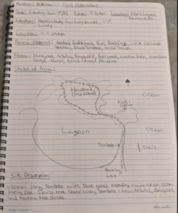
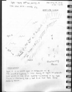
The area I have chosen for this study is Pipers Lagoon, located in Nanaimo B.C. I visited the area on January 9th at approximately 9:40 am. The weather was mainly cloudy with a few sunny breaks, ~4 degrees in temperature, and fairly windy. Low tide in this area had occurred at 7:39 am.

The entire park area is approximately 8 hectares in size and consists of a tidal mudflat (the lagoon), an approximately 300m long tombolo or sandy isthmus, and a rocky headland or tied island. It is a well-visited site year-round, with a somewhat rugged trail system that loops the entire tied island. Elevation change is approximately 20m (according to alltrails.com) between sea level at the tombolo and the high point on the tied island.

The tombolo which has a relatively flat topography and predominantly grassy vegetation connects the mainland Vancouver Island with the rocky headland or tied island. The eastern side of the tombolo is exposed to the open ocean, consists of an abundance of dunegrass, and has a predominantly pebble-sized substrate. The Western side which is exposed to the lagoon waters generally lacks dunegrass but has an abundance of various other smaller-sized grasses and has a much smaller and finer substrate. 

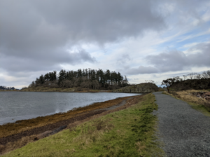
Figure 1: Looking North Towards Tied Island Along Tombolo

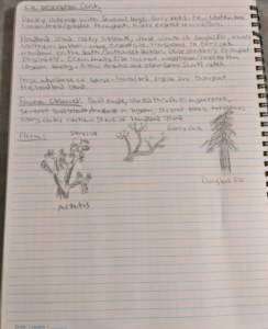
The lagoon itself undergoes daily tidal fluctuations but was pretty well entirely underwater when I arrived. The tied island which is approximately 5 hectares in size consists of multiple rocky outcrops where various lichen, moss, and broad-leaved stonecrop were observed. The smaller rocky outcrop was dominated by mainly Garry Oak, with a couple small arbutus also observed. The main tied island had a variety of vegetation including Ocean Spray, Nootka Rose, and the invasives Spurge-Laural and English Ivy. Tree species observed here were Douglas Fir, Garry Oak, and Arbutus. The northern, exposed portion of the tied island was dominated by Douglas Fir, while the south-facing side formed a typical Garry Oak ecosystem, with Camas known to bloom here in the Spring.

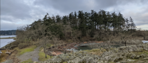
Figure 2: Garry Oak and Douglas Fir on Tied Island

The area is well known for birding and I was fortunate to observe several species including Mallard, Bufflehead, Glaucous-Winged Gull, Bald Eagle, White-Crowned Sparrow, Black Turnstone, and a Varied Thrush.

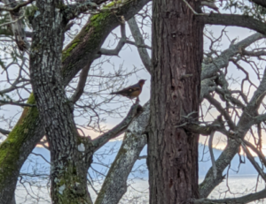
Figure 3: Varied Thrush in Garry Oak


Potential Study Questions

Based on my initial field observations here are three questions that may form the basis of my study.

Question 1: Does exposure to salt spray determine the abundance and distribution of the Broad-Leaved Stonecrop?

It was noted that the stonecrop was generally found along bluffs exposed to the ocean as opposed to the lagoon.

Question 2: Does the difference in substrate composition of the lagoon compared to the beach (on the other side of the tombolo) impact species diversity?

Although the tide was up fairly high I imagine the species diversity between the lagoon and the beach area must be at least somewhat impacted by the substrate.

Question 3: Do the tree species composition and diversity change from mid tied island to the perimeter with sun exposure?

It was noted that the majority of Garry Oak on the tied Island were concentrated on the more southern facing side, while the Douglas Fir was denser in the north direction.


Field Notes:

Blog Post 2: Sources of Scientific Information

I chose an article entitled, Feeding ecology of Atlantic bluefin tuna (Thunnus thynnus) in the Gulf of Saint Lawrence, Canada found in the Thompson Rivers University (TRU) Library. The article can be found in Marine Environmental Research.

Looking over this article, and from what I learned in our tutorial, I believe this is an academic peer-reviewed research article.

I’ve deemed this article as academic primarily due to the contributing authors and their affiliation with the Biology Department at Acadia University in Nova Scotia, Canada (Figure 1). Two other contributing factors are that the journal this article was published in is considered a research journal (Figure 2) and secondly, TRU Library allows one to be able to refine their search to retrieve academic journals (Figure 3). The article would also be considered academic due to the amount of in-text citations (Figure 4) and the reference list at the end of the article (Figure 5).

I believe the article is peer-reviewed based off of the timeline outlining the manuscript received date, the revision date, and the publication date (Figure 6) and as previously mentioned, I specifically searched for peer-reviewed articles in the TRU Library (Figure 7).

References

Varela, J. L.,  Spares, A. D., Stokesbury, M. J. W. 2020, October 16. Feeding ecology of Atlantic bluefin tuna (Thunnus thynnus) in the Gulf of Saint Lawrence, Canada. Marine Environmental Research. V 161. 105087, ISSN 0141-1136. Retrieved from https://doi.org/10.1016/j.marenvres.2020.105087.

Figures

Post 8: Tables and Graphs

When creating my graph, I found it hard to properly display the diverse content I was recording neatly in one space. When attempting to create separate graphs, they showed no correlation with the point I was trying to prove. Upon its completion, I found it lacking in the specifics while not being laid out the way that was expected for the course. I was able to show the correlation between my points of research and the topic I am studying. My data was lacking water pollution and land pollution levels that I could not measure with current equipment. I feel that would provide a more accurate picture of long term effects of pollution on creek health.

Blog Post 1: Observations

I’ve had to change my location, so this is an updated observation. I choose to pick a bigger location closer to my house. I decided to pick a length of the dyke along a common road in Surrey, BC. The length of the dyke is about .6 km. I choose this location due to the about of wildlife and components of the environment along the dyke. The top of dyke A (dyke B is running parallel) is well worn, but always a quiet dyke in comparison to dyke B. The two dyke paths are separated by a large canal of water, about 15 feet across. There is a combination of tall yellow grass and brambles that make it difficult to venture down to the canal, but entirely possible.

As it was a clear day, there were plenty of animals out. I heard several hawk or falcon calls, crows in the surrounding trees, some human traffic from the nearby roads, construction from the nearby complexes and a tractor in the blueberry field on the right side of dyke A (if facing SE). There was evidence of animals from the scat along the trail, paw prints in the mud, ducks and a few loons swimming in the canal and crows flying overhead.

There was plenty of plants that I was not familiar with. Brambles along the shoreline, tall yellowing grass on either side of the dyke, green short grass along the trail with spots of clover and dandelion weeds. Mixed into the tall yellowing grass there were brown tall plants with seeds and dying flower heads of some sort. I was not familiar with them, but they might potentially be thistles.

Overall, it was a great first observation of this location. I have many things to ponder about how to create my hypothesis and test it out.

A few questions I had:

  1. How does precipitation effect the dyke’s ecology system?
  2. Does the dyke water levels rise and fall frequently?
  3. Are there bugs and fish that I was not able to observe?
  4. How does the blueberry farm effect the dyke?

I’m looking forward to returning, observing the nature another day, and answering some of my questions. Below are some of my field notes from my adventure.

Blog Post 9: Field Research Reflections

I had several issues through the process of designing and carrying out the field experiment. Most of which related to formulation of a solid hypothesis and a corresponding experiment that was feasible within time and scope constraints. Small but significant changes had to made to the sample selection and randomization process. Also, my hypothesis needed to be rethought on two occasions.

This was not my first experience with field experimentation but it was certainly the most difficult to complete. My appreciation for the amount of hard work and critical thought required to perform ecology in the field has been renewed.


Blog post 2: Sources of Scientific Information

The article I’ve chosen for this exercise is a paper published by the journal Ecology entitled: Spatially nonrandom tree mortality and ingrowth maintain equilibrium pattern in an old-growth Pseudotsuga–Tsuga forest.

It can be found by going to this link:

https://www-jstor-org.ezproxy.tru.ca/stable/43494711

The article can be classified as academic, peer-reviewed research material based on the following evidence (images were taken from the paper and provide documentation):

The authors appear to be experts in their fields as proven by their university affiliations, in-text citations, and a literature cited section.

The paper was peer-reviewed by anonynous reviewers whom the authors acknowledged.

It was a research paper: it contained a methods and results section.


Blog Post 1: Observations

The area I have chosen as a field site encompasses roughly 50 hectares of land and lakeside in the Lakes District approximately one hour south of Burns Lake BC. It is located within a couple hundred meters of a relatively small lake called Bickle lake and is partially on private land (permission to access granted) and partially on crown land designated as “Old Growth management area” by the Province. The ecosystem classification of the entire site as per BEC-web is Sub-boreal Spruce dry-cool (dk) with some site series variation. Slopes are minor with some short steep sections directly adjacent to the lake. My area of interest will likely become smaller as I refine my research question but for now I’m looking at several environmental gradients. These include two particular areas which I will describe in the following paragraphs documenting my initial site visits.

The first area was visited on January 4th, 2021 at around 4:05 pm, accessed by cross-country skiing on the lake. The weather was clear, sunny (sunset) and the temperature was around -1 degree Celsius.   Located on a promontory of the lake south of the private property, this section of forest is within the Old Growth Management Area (OGMA) (iMap BC) and has forested lakeside edges that are both north, west, and southwest-facing. Along the north aspect the stand contains large-volume spruce with a good deal of blown-down dead pine (most of the pine in the area was killed by the Mountain Pine beetle epidemic in the early 2000s), which gives way to younger spruce towards the point of the promontory, and then an open aspen-leading stand on west- and southwest facing slopes. I saw old moose prints on the lake and the willows along the shore were browsed so heavily they looked spiky, though the interspersed alder was not browsed. I saw and heard several ravens flying by, but saw no other live animals. A large raptor nest (known from previous summers to be bald eagle-made) was located at the top of a tall aspen
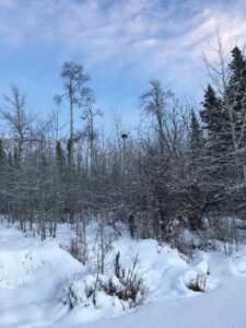
, and I saw a cavity nest on an aspen snag at the point of the promontory.

The second area was visited January 7th, 2021 at around 9:05 am, accessed by snowshoe. The weather was calm, partially cloudy, just after dawn and approximately -9 degrees Celsius. Located within the private property north of the OGMA, the site is on the edge between a partial-harvest clearcut (logged circa late 1990s) and the mature mixed forest directly south of it which leads down to Bickle lake. This clearcut is undergoing natural reforestation (it wasn’t planted) and the lakeside is also undergoing a succession process as it was heavily influenced by beaver activity 15-20 years ago. I walked through moose tracks that were left days ago as well as weeks ago. I noticed how spruce and aspen regeneration was occurring in a patchy manner, with dense heavy clumps and strips scattered between sparser strips. Within the adjacent forest were places where criss-crossing immature spruce blowdown cluttered the forest floor, as well as places where larger spruce and aspen had fallen. Was this just natural forest disturbance? Was it related to the “edge effect” of the clearcut? Or could it be that the wind events that have been occurring have been more severe recently? (Due to climate change?) As I walked into the mature forest I felt, saw, and heard the presence of more animal life. I watched a squirrel munching on spruce cones (and it watched me) and heard several squirrel alarm calls. I heard chickadees calling; and I followed the tracks of a small canine – probably red fox. I noticed a large opening with blown-down trees with 5-6 scattered trees broken off at around 5m, some live, some dead.


Field observations
Observations of moose tracks, browse, and squirrel

Three initial questions come to mind regarding my observations:

  1. Why is there an apparent difference in tree species concentrations on different aspects – even within a small “old growth” area? What ecological attributes form the basis of a designation such as “old growth management area,” and can these attributes be measured in differently organized forest stands? (e.g. open aspen stands with heavy saskatoon/snowberry shrub component as opposed to a high-volume spruce stand)
  2. Does the heavy density of coniferous regeneration that appeared to naturally return to a harvested site – similar to the super-heavy pine ingress I’ve observed following a forest fire – provide some sort of stand resilience or biodiversity advantage as succession progresses? I’m comparing Nature’s method of succession to the Industry standard of an evenly-spaced tree crop.
  3. The heavily browsed forage species I observed at first made me question whether there was inadequate browse options to support the local moose population but this goes against local anecdotal evidence which suggests moose populations aren’t at over-capacity. Also, upon further observation, there appeared to be plenty of browse species individuals that were hardly touched by moose. Could plant individuals that were hyper-browsed simply be located in moose thoroughfares and were thus casualties of being “along the main trail?” Or could there be some strategy at play to produce more new shoots on one plant individual, thus decreasing a moose’s need to travel further than otherwise?

Blog Post 1 – Observations

Observation Area and Topography

The area I have selected to observe is a 1 km2 area in Western Ukraine. The area has been chosen primarily due to its accessibility, multiple environmental gradients and its densely populated communities of various animals. The land consists of a gentle sloped hill descending from south to north with a shallow creek bed and stagnant pond on the western aspect, I have been in this area throughout every day for the past few months so it is easy to observe and document daily and hourly changes and behaviors on a regular basis.

Map of Observation Area

Vegetation

Most of the area consisting of mixed temperate forest, creeks and swamp blending into an urban park with some permanent buildings. The forest consists of primarily mixed types of pine and large old growth oak. The forest floor is a mix of smaller plants and shrubs but is clear enough in most places to walk under the trees without becoming entangled in the brush. Among the scrub brush there are poison ivy plants. In lower areas near the ponds the undergrowth becomes almost impassible with various types of bush like plants such as raspberry. These are fed by the higher water concentration in the thick black soil. The urban area is sparsely populated by cypress, old growth oak and pine trees that initial grew prior to the laying of brick paths between the buildings. The grass, likely a human addition, has grown over a grey sandy soil, in the urban area is maintained once every month or so, but is mostly left untouched unless it is tall enough to go to seed.

Drawings from field journal

Wildlife

There are a number of animals who live in the area. Rarely seen is the Red squirrel, (Sciurus vulgaris) populates the trees, while the moles are predominantly in the sandy area of the urban grass. There are many feral dogs which roam far and wide as new packs enter and exit the observation area as food or mates become sparse. A smaller number of different coloured feral cats (likely not from the same litter) stay in the area to prey on the mice, birds, squirrels and the occasional mole. Of note the only birds seen are seagulls, which have left the area due to winter, and the yellow Parus Major which flits around between the worm rich ground and the thick cover of the cypress and pine trees. Some of the feral dogs have had visibly engorged ticks on them as well. There have been no turtles nor fish seen in the pond but it is not well oxygenated by plants, as it contains a great deal of decomposing leaves from the deciduous trees and very little movement from the tiny creek.

Weather

From October to January the weather has transitioned to cool fall to mild winter. Short periods of light rain showers, and a persistent overcast winter sky are rarely disturbed by any significant wind greater than what could be described as a breeze. Despite the winter season the weather here is mild enough for the temperature to range between an average of -5oc at night to +10oc during the day. It has only snowed three times, and it rarely lasts longer than a day or two before melting away.


Questions

  1. Since none of the dog spoor has been seen anywhere in the area, where do the feral dogs defecate? Is it a centralized location?
  2. The moles appear to continue pushing upward and creating molehills, but I am curious if there may be a correlation between soil temp and activity and or the activity of the prolific earthworms?
  3. Does the predation of moles by cats and dogs effect the location of the mole colonies?

Blog Post 8: Tables and Graphs

My figure was relatively easy to put together. It showed the mean number of stems/quadrat counted in each of my treatment areas. As it was a simple comparison between the treatment areas and means, it was not a problem to describe or summarize.

The outcome of the figure was as expected with the calculated values matching what had been visually observed in the field.

The data did give me an idea for further research. The differences in mean values was fairly large and I am wondering if there might be more at play than just mowing frequency that is causing the different growth patterns in the vine.

Blog Post 9: Field Research Reflections

This was a completely new process for me. Developing and implementing my experiment came with many challenges. I was often second guessing myself and certain stages of the experimental design took much longer then anticipated. I also realized that at a certain stage there is no turning back even if you are not pleased with everything. A lot of time goes into a good field project. I ended up doubling the amount of samples I collected because I realized that I did not initially have enough to minimize bias.

I have gained an appreciation for the amount of effort, time, and hard work that goes into a successful research project. This came as somewhat of a surprise to me, considering the simplicity of my project in comparison to other research work. I was reminded that ecological theory takes time to develop and it is only as good as the relevant work from other ecologists. This point highlights the need for quality and quantity of literature in order to speak of any given topic with a reasonable level of certainty.